Unterföhring (Unterföhring)

- municipality of Germany. near the city of Munich
 Hiking in Unterföhring
Unterföhring, located near Munich, Germany, offers a variety of outdoor activities, including hiking. While it may not be a mountainous region, it features beautiful natural surroundings and well-maintained trails that are suitable for different skill levels. Here are some key points to consider when hiking in Unterföhring:
Trails and Parks
-
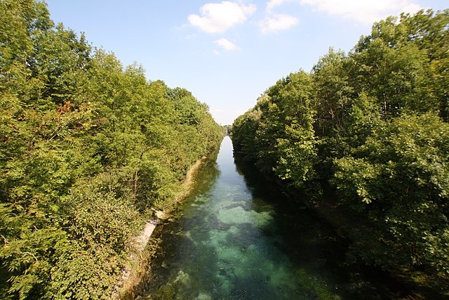
Isar River Trails: One of the most popular hiking routes is along the Isar River. The trails offer scenic views, shaded paths, and a chance to enjoy the local flora and fauna.
-
Surrounding Nature: The area is surrounded by fields and forests, providing additional trails for those looking to explore more rustic settings.
-
Local Parks: Unterföhring has several parks where you can enjoy shorter hikes or leisurely walks. These include green spaces that can be explored with family or friends.
Difficulty Levels
- The trails in and around Unterföhring are generally easy, making them accessible for families, beginners, and casual hikers.
- For more experienced hikers, you can connect to longer trails that head toward the nearby Bavarian countryside.
Tips for Hiking in Unterföhring
-
Plan Your Route: While the trails are generally well marked, it’s good to have a map or a hiking app for guidance, especially if you plan to head into less familiar areas.
-
Local Weather: Always check the weather before heading out to ensure you're dressed appropriately and prepared for changes in conditions.
-
Hydration and Snacks: Bring plenty of water and snacks, especially if you plan on hiking for several hours.
-
Respect Nature: Stay on marked trails, respect wildlife, and be mindful of local regulations regarding pets and campfires.
Getting There
Unterföhring is well-connected by public transport from Munich, making it an easily accessible destination for day hikes. Consider taking the S-Bahn to Underrföhring station for direct access to many of the local trails.
Conclusion
Hiking in Unterföhring offers a great way to enjoy the outdoors, away from the hustle and bustle of the city. Whether you’re looking for a short walk or a longer hike, the area provides a peaceful and picturesque setting perfect for nature lovers. Enjoy your hike!
- Country:

- Postal Code: 85774
- Local Dialing Code: 089
- Licence Plate Code: M
- Coordinates: 48° 11' 30" N, 11° 39' 10" E


- GPS tracks (wikiloc): [Link]
- AboveSeaLevel: 507 м m
- Area: 12.80 sq km
- Population: 10948
- Web site: http://www.unterfoehring.de
- Wikipedia en: wiki(en)
- Wikipedia: wiki(de)
- Wikidata storage: Wikidata: Q267408
- Wikipedia Commons Category: [Link]
- Wikipedia Commons Maps Category: [Link]
- Freebase ID: [/m/0c6d7m]
- GeoNames ID: Alt: [2819568]
- VIAF ID: Alt: [239495104]
- OSM relation ID: [2168251]
- GND ID: Alt: [4119301-5]
- archINFORM location ID: [5570]
- MusicBrainz area ID: [cd556a40-b719-46e4-a6ba-0f6e4db91702]
- WOEID: [700947]
- Bavarikon ID: [ODB_A00001249]
- German municipality key: 09184147
Shares border with regions:


Ismaning
- municipality of Germany
Hiking in Ismaning
Ismaning is a charming municipality located just northeast of Munich, Germany. While it's not as mountainous as other regions in Bavaria, it does offer some lovely hiking opportunities, especially for those who enjoy picturesque landscapes and serene environments....
- Country:
- Postal Code: 85737
- Local Dialing Code: 089
- Licence Plate Code: M
- Coordinates: 48° 13' 35" N, 11° 40' 21" E
- GPS tracks (wikiloc): [Link]
- AboveSeaLevel: 490 м m
- Area: 40.19 sq km
- Population: 16770
- Web site: [Link]

Aschheim
- municipality of Germany
Hiking in Aschheim
Aschheim is a small town located near Munich, Germany. While it may not be known as a major hiking destination, it offers access to some pleasant walking and hiking opportunities, especially in the surrounding areas....
- Country:
- Postal Code: 85609
- Local Dialing Code: 089
- Licence Plate Code: M
- Coordinates: 48° 10' 24" N, 11° 43' 4" E
- GPS tracks (wikiloc): [Link]
- AboveSeaLevel: 512 м m
- Area: 28.04 sq km
- Population: 8870
- Web site: [Link]