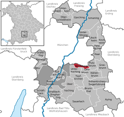
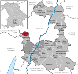
Munich (Landkreis München)
.svg)
- district of Bavaria, Germany
 Hiking in Munich
Hiking in and around Munich, the capital of Bavaria, offers a wonderful blend of urban landscapes and stunning natural scenery. While Munich itself is a vibrant city with parks and green spaces, many hiking opportunities are just a short distance away in the surrounding region.
Popular Hiking Areas Near Munich
-
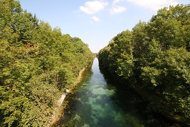
Isar River Trails:
- The Isar River runs through Munich and offers several scenic walking and biking paths along its banks. You can enjoy leisurely walks, picnics, and beautiful spots to relax.
-
Nymphenburg Park:
- This large park surrounds the Nymphenburg Palace and offers lovely walking paths, gardens, and a picturesque setting. It's a great option for a more relaxed hike within the city.
-
Tegernsee:
- Located about an hour's train ride from Munich, the Tegernsee area offers a variety of hiking trails with stunning views of the lake and mountains. The Rottach-Egern and Gmund regions are particularly popular for day hikes.
-
Starnberger See:
- Another accessible lake region, Starnberger See has numerous hiking routes along its shores. The area is known for its beautiful landscapes and historical sites.
-
The Bavarian Alps:
- Although a bit further, the Alps are reachable within an hour or two from Munich. Popular hiking destinations include the Zugspitze, Germany's highest peak, and the trails around Garmisch-Partenkirchen, which offer breathtaking views and various difficulty levels.
Tips for Hiking in Munich
-
Transportation: Munich has an excellent public transport system, including trains and U-Bahn, that can take you to many hiking starting points quickly and efficiently.
-
Weather: The climate can vary, so check forecasts and prepare for changing conditions. Summer can be warm and sunny, while fall can bring rain and cooler temperatures.
-
Gear: Wear appropriate hiking shoes, and bring water, snacks, and a map or GPS device. Trekking poles can also be helpful, especially in hilly areas.
-
Local Resources: Consider stopping by the Munich Tourist Information Center for maps and recommendations on trails specific to your interests and fitness level.
-
Guided Hikes: If you're new to hiking, consider joining a guided tour to explore the best local trails safely.
Whether you're looking for a leisurely stroll or a more challenging hike, Munich and its surrounding areas provide a wealth of opportunities to enjoy the great outdoors.
- Country:

- Capital: Munich
- Local Dialing Code: 089
- Licence Plate Code: WOR; M; AIB
- Coordinates: 48° 0' 0" N, 11° 40' 12" E


- GPS tracks (wikiloc): [Link]
- AboveSeaLevel: 513 м m
- Area: 52020.58 sq km
- Population: 343405
- Web site: http://www.landkreis-muenchen.de/
- Wikipedia en: wiki(en)
- Wikipedia: wiki(de)
- Wikidata storage: Wikidata: Q10544
- Wikipedia Commons Gallery: [Link]
- Wikipedia Commons Category: [Link]
- Wikipedia Commons Maps Category: [Link]
- Freebase ID: [/m/01t23v]
- GeoNames ID: Alt: [3220838]
- VIAF ID: Alt: [243426463]
- OSM relation ID: [62580]
- GND ID: Alt: [4040573-4]
- archINFORM location ID: [2526]
- TGN ID: [7077292]
- Historical Gazetteer (GOV) ID: [adm_139184]
- Bavarikon ID: [ODB_A00002356]
- NUTS code: [DE21H]
- BabelNet ID: [02452029n]
- German district key: 09184
Includes regions:

Forstenrieder Park
- unincorporated area in Germany
Hiking in Forstenrieder Park
Forstenrieder Park, located in Bavaria, Germany, is a beautiful area for hiking, known for its scenic landscapes and well-maintained trails. The park encompasses roughly 1,000 hectares of woodland, meadows, and diverse wildlife, making it an excellent spot for outdoor enthusiasts. Here are some highlights and tips for hiking in Forstenrieder Park:...
- Country:
- Coordinates: 48° 2' 49" N, 11° 27' 40" E
- GPS tracks (wikiloc): [Link]
- AboveSeaLevel: 606 м m
- Area: 37.08 sq km


Grünwalder Forst
- unincorporated area in Germany
Hiking in Grünwalder Forst
Grünwalder Forst is a beautiful forest area located near Grünwald, a district south of Munich, Germany. It offers a variety of hiking opportunities that cater to different skill levels and preferences. Here are some details to consider if you're planning a hike in Grünwalder Forst:...
- Country:
- Coordinates: 48° 1' 24" N, 11° 32' 5" E
- GPS tracks (wikiloc): [Link]


Pullach
- municipality of Germany
Hiking in Pullach
Pullach, located in Bavaria, Germany, is situated in a picturesque area near the banks of the Isar River, just south of Munich. It offers a variety of hiking opportunities that cater to various skill levels, making it a delightful destination for outdoor enthusiasts....
- Country:
- Postal Code: 82049
- Local Dialing Code: 089
- Licence Plate Code: M
- Coordinates: 48° 3' 40" N, 11° 31' 17" E
- GPS tracks (wikiloc): [Link]
- AboveSeaLevel: 582 м m
- Area: 7.41 sq km
- Population: 7655
- Web site: [Link]


Grünwald
- municipality of Germany
Hiking in Grünwald
Grünwald, located in Bavaria, Germany, is a charming town that provides excellent opportunities for hiking and exploring the beautiful Bavarian countryside. While Grünwald itself is small, it is situated near the foothills of the Alps, giving hikers access to a range of trails suitable for various skill levels....
- Country:
- Postal Code: 82064; 82031
- Local Dialing Code: 089
- Licence Plate Code: M, AIB, WOR
- Coordinates: 48° 2' 0" N, 11° 31' 0" E
- GPS tracks (wikiloc): [Link]
- AboveSeaLevel: 585 м m
- Area: 8 sq km
- Population: 11086
- Web site: [Link]


Aying
- municipality of Germany
Hiking in Aying
Aying is a charming town located in Bavaria, Germany, known for its picturesque landscapes and proximity to nature, making it a great starting point for hiking enthusiasts. The surrounding area features rolling hills, lush forests, and scenic trails that can accommodate a range of hiking skill levels....
- Country:
- Postal Code: 85653
- Local Dialing Code: 08102; 08095; 08093; 08063
- Licence Plate Code: M
- Coordinates: 47° 58' 0" N, 11° 47' 0" E
- GPS tracks (wikiloc): [Link]
- AboveSeaLevel: 610 м m
- Area: 44.98 sq km
- Population: 5074
- Web site: [Link]


Brunnthal
- municipality of Germany
Hiking in Brunnthal
Brunnthal, located near Munich in Bavaria, Germany, offers a variety of hiking opportunities for outdoor enthusiasts. The area is characterized by its picturesque landscapes, lush forests, and gentle rolling hills, making it suitable for hikers of all skill levels....
- Country:
- Postal Code: 85649
- Local Dialing Code: 08104; 08102
- Licence Plate Code: M
- Coordinates: 48° 1' 0" N, 11° 41' 0" E
- GPS tracks (wikiloc): [Link]
- AboveSeaLevel: 592 м m
- Area: 26.92 sq km
- Population: 3242
- Web site: [Link]


Perlacher Forst
- unincorporated area in Germany
Hiking in Perlacher Forst
Perlacher Forst is a beautiful wooded area located near Munich, Germany, and it offers a wonderful opportunity for hiking enthusiasts. Here are some key points about hiking in Perlacher Forst:...
- Country:
- Coordinates: 48° 4' 2" N, 11° 34' 36" E
- GPS tracks (wikiloc): [Link]
- AboveSeaLevel: 564 м m


Oberschleißheim
- municipality of Germany
Hiking in Oberschleißheim
Oberschleißheim, located just north of Munich in Bavaria, Germany, offers a charming setting for hiking enthusiasts. The area is characterized by its picturesque landscapes, with a mix of forests, meadows, and lakes that provide a serene escape from urban life....
- Country:
- Postal Code: 85764
- Local Dialing Code: 089
- Licence Plate Code: M
- Coordinates: 48° 15' 0" N, 11° 34' 0" E
- GPS tracks (wikiloc): [Link]
- AboveSeaLevel: 483 м m
- Area: 30.60 sq km
- Population: 10034
- Web site: [Link]


Ismaning
- municipality of Germany
Hiking in Ismaning
Ismaning is a charming municipality located just northeast of Munich, Germany. While it's not as mountainous as other regions in Bavaria, it does offer some lovely hiking opportunities, especially for those who enjoy picturesque landscapes and serene environments....
- Country:
- Postal Code: 85737
- Local Dialing Code: 089
- Licence Plate Code: M
- Coordinates: 48° 13' 35" N, 11° 40' 21" E
- GPS tracks (wikiloc): [Link]
- AboveSeaLevel: 490 м m
- Area: 40.19 sq km
- Population: 16770
- Web site: [Link]


Planegg
- municipality of Germany
Hiking in Planegg
Planegg is a charming town located near Munich, Germany, and while it may not be as widely known for its hiking trails, it offers access to lovely walks and hiking opportunities in the surrounding areas. Here are some things to consider when planning a hiking trip in and around Planegg:...
- Country:
- Postal Code: 82152
- Local Dialing Code: 089
- Licence Plate Code: M
- Coordinates: 48° 6' 17" N, 11° 25' 50" E
- GPS tracks (wikiloc): [Link]
- AboveSeaLevel: 542 м m
- Area: 10.68 sq km
- Population: 10758
- Web site: [Link]


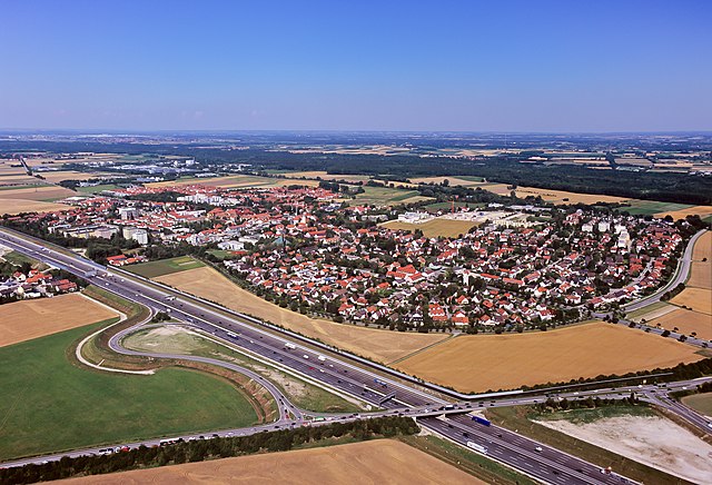
Taufkirchen
- municipality of Germany
Hiking in Taufkirchen
Taufkirchen, located just south of Munich in Bavaria, offers some great opportunities for hiking as it serves as a gateway to the picturesque landscapes of the surrounding region. While Taufkirchen itself is more suburban, its proximity to natural areas and parks makes it a convenient starting point for various outdoor activities....
- Country:
- Postal Code: 82024
- Local Dialing Code: 089
- Licence Plate Code: M
- Coordinates: 48° 2' 55" N, 11° 37' 1" E
- GPS tracks (wikiloc): [Link]
- AboveSeaLevel: 563 м m
- Area: 22 sq km
- Population: 17947
- Web site: [Link]

Neubiberg
- municipality of Germany
Hiking in Neubiberg
Neubiberg, located in Bavaria, Germany, is a quaint town situated near Munich. While it may not be widely known for extensive hiking trails compared to larger areas like the Bavarian Alps, it does offer some opportunities for outdoor activities and nearby hiking experiences....
- Country:
- Postal Code: 85579
- Local Dialing Code: 089
- Licence Plate Code: M
- Coordinates: 48° 5' 0" N, 11° 41' 0" E
- GPS tracks (wikiloc): [Link]
- AboveSeaLevel: 551 м m
- Area: 5.77 sq km
- Population: 13480
- Web site: [Link]


Neuried
- municipality in Bavaria, Germany
Hiking in Neuried
Neuried, located in Bavaria, Germany, is a picturesque area characterized by its natural beauty and charming rural landscapes, making it a great destination for hiking enthusiasts. Here's a brief overview of what you might expect when hiking in and around Neuried:...
- Country:
- Postal Code: 82131; 82061
- Local Dialing Code: 089
- Licence Plate Code: M
- Coordinates: 48° 5' 36" N, 11° 27' 57" E
- GPS tracks (wikiloc): [Link]
- AboveSeaLevel: 559 м m
- Area: 9.63 sq km
- Population: 8628
- Web site: [Link]


Grasbrunn
- municipality of Germany
Hiking in Grasbrunn
Grasbrunn is a town in Bavaria, Germany, located just east of Munich. While it may not be widely known as a hiking destination, there are still several opportunities for outdoor enthusiasts to explore the natural beauty of the surrounding area....
- Country:
- Postal Code: 85630
- Local Dialing Code: 089
- Licence Plate Code: M
- Coordinates: 48° 4' 44" N, 11° 44' 37" E
- GPS tracks (wikiloc): [Link]
- AboveSeaLevel: 556 м m
- Area: 26.39 sq km
- Population: 3517
- Web site: [Link]


Putzbrunn
- municipality of Germany
Hiking in Putzbrunn
Putzbrunn is a small municipality located in Bavaria, Germany, close to the city of Munich. While it may not be a well-known hiking destination on its own, its proximity to various natural areas makes it a convenient starting point for outdoor enthusiasts. Here are some insights into hiking in and around Putzbrunn:...
- Country:
- Postal Code: 85640
- Local Dialing Code: 089
- Licence Plate Code: M
- Coordinates: 48° 4' 33" N, 11° 42' 57" E
- GPS tracks (wikiloc): [Link]
- AboveSeaLevel: 556 м m
- Area: 11.17 sq km
- Population: 6464
- Web site: [Link]
Feldkirchen, Upper Bavaria
- municipality of Germany
Hiking in Feldkirchen, Upper Bavaria
Feldkirchen, located in Upper Bavaria, is a charming village surrounded by beautiful landscapes, making it a wonderful destination for hiking enthusiasts. The area is characterized by its rolling hills, lush forests, and scenic farmland, providing a variety of hiking opportunities for all experience levels....
- Country:
- Postal Code: 85622
- Local Dialing Code: 089
- Licence Plate Code: M
- Coordinates: 48° 9' 0" N, 11° 44' 0" E
- GPS tracks (wikiloc): [Link]
- AboveSeaLevel: 526 м m
- Area: 6.41 sq km
- Population: 7241
- Web site: [Link]

Garching bei München
- town in Bavaria, Germany
Hiking in Garching bei München
Garching bei München is primarily known as a residential and research community located just north of Munich, Germany. Although Garching itself is not renowned for extensive hiking trails, it does provide access to several nearby outdoor opportunities and nature areas. Here are some suggestions for hiking and outdoor activities in and around Garching:...
- Country:
- Postal Code: 85748
- Local Dialing Code: 089
- Licence Plate Code: M
- Coordinates: 48° 15' 0" N, 11° 39' 0" E
- GPS tracks (wikiloc): [Link]
- AboveSeaLevel: 482 м m
- Area: 28.16 sq km
- Population: 11587
- Web site: [Link]


Unterhaching
- German municipality, located in the state of Bavaria
Hiking in Unterhaching
Unterhaching, located in Bavaria, Germany, is a charming town just south of Munich, making it a great starting point for various outdoor activities, including hiking. While Unterhaching itself may not have extensive hiking trails, its proximity to larger natural areas and the Bavarian countryside offers plenty of opportunities for hiking enthusiasts....
- Country:
- Postal Code: 82008
- Local Dialing Code: 089
- Licence Plate Code: M, AIB, WOR
- Coordinates: 48° 3' 58" N, 11° 36' 56" E
- GPS tracks (wikiloc): [Link]
- AboveSeaLevel: 556 м m
- Area: 15 sq km
- Population: 17260
- Web site: [Link]


Unterföhring
- municipality of Germany. near the city of Munich
Hiking in Unterföhring
Unterföhring, located near Munich, Germany, offers a variety of outdoor activities, including hiking. While it may not be a mountainous region, it features beautiful natural surroundings and well-maintained trails that are suitable for different skill levels. Here are some key points to consider when hiking in Unterföhring:...
- Country:
- Postal Code: 85774
- Local Dialing Code: 089
- Licence Plate Code: M
- Coordinates: 48° 11' 30" N, 11° 39' 10" E
- GPS tracks (wikiloc): [Link]
- AboveSeaLevel: 507 м m
- Area: 12.80 sq km
- Population: 10948
- Web site: [Link]


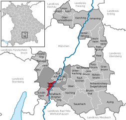
Straßlach-Dingharting
- municipality of Germany
Hiking in Straßlach-Dingharting
Straßlach-Dingharting, located near Munich in Bavaria, Germany, provides hikers with a pleasant natural environment characterized by scenic landscapes, rolling hills, and lush forests. Here are some highlights and tips for hiking in this area:...
- Country:
- Postal Code: 82064
- Local Dialing Code: 08170
- Licence Plate Code: M
- Coordinates: 48° 0' 18" N, 11° 30' 51" E
- GPS tracks (wikiloc): [Link]
- AboveSeaLevel: 635 м m
- Area: 28.34 sq km
- Population: 2435
- Web site: [Link]

Baierbrunn
- municipality of Germany
Hiking in Baierbrunn
Baierbrunn is a charming village located in Bavaria, Germany, and is known for its beautiful natural landscapes, making it a great destination for hiking enthusiasts. The area is part of the picturesque foothills of the Alps and is surrounded by forests, meadows, and rivers, providing diverse hiking opportunities....
- Country:
- Postal Code: 82065
- Local Dialing Code: 089
- Licence Plate Code: M
- Coordinates: 48° 1' 0" N, 11° 29' 0" E
- GPS tracks (wikiloc): [Link]
- AboveSeaLevel: 626 м m
- Area: 7.21 sq km
- Population: 2176
- Web site: [Link]

Aschheim
- municipality of Germany
Hiking in Aschheim
Aschheim is a small town located near Munich, Germany. While it may not be known as a major hiking destination, it offers access to some pleasant walking and hiking opportunities, especially in the surrounding areas....
- Country:
- Postal Code: 85609
- Local Dialing Code: 089
- Licence Plate Code: M
- Coordinates: 48° 10' 24" N, 11° 43' 4" E
- GPS tracks (wikiloc): [Link]
- AboveSeaLevel: 512 м m
- Area: 28.04 sq km
- Population: 8870
- Web site: [Link]


Haar
- municipality of Germany
Hiking in Haar
Haar, located just east of Munich in Bavaria, offers a mix of urban and natural experiences for hikers. While Haar itself is more of a suburban area, the proximity to various green spaces and parks makes it a great starting point for exploring hiking trails in the surrounding region. Here are some highlights for hiking enthusiasts in and around Haar:...
- Country:
- Postal Code: 85540
- Local Dialing Code: 089
- Licence Plate Code: M
- Coordinates: 48° 6' 0" N, 11° 44' 0" E
- GPS tracks (wikiloc): [Link]
- AboveSeaLevel: 542 м m
- Area: 12.90 sq km
- Population: 16645
- Web site: [Link]

Gräfelfing
- municipality of Germany
Hiking in Gräfelfing
Gräfelfing, located in Bavaria, Germany, is a charming municipality near Munich, which provides access to various outdoor activities, including hiking. While Gräfelfing itself is more residential, it serves as a good base for exploring the surrounding natural areas....
- Country:
- Postal Code: 82166
- Local Dialing Code: 089
- Licence Plate Code: M
- Coordinates: 48° 7' 8" N, 11° 25' 44" E
- GPS tracks (wikiloc): [Link]
- AboveSeaLevel: 540 м m
- Area: 9.58 sq km
- Population: 13816
- Web site: [Link]


Kirchheim bei München
- municipality of Germany
Hiking in Kirchheim bei München
Kirchheim bei München, located just northeast of Munich, is surrounded by beautiful landscapes and offers several hiking opportunities for outdoor enthusiasts. The region is characterized by scenic trails that weave through lush forests, charming fields, and picturesque views of the Bavarian Alps in the distance....
- Country:
- Postal Code: 85551
- Local Dialing Code: 089
- Licence Plate Code: M
- Coordinates: 48° 10' 36" N, 11° 45' 20" E
- GPS tracks (wikiloc): [Link]
- AboveSeaLevel: 511 м m
- Area: 15.5 sq km
- Population: 12967
- Web site: [Link]


Höhenkirchen-Siegertsbrunn
- municipality of Germany
Hiking in Höhenkirchen-Siegertsbrunn
Höhenkirchen-Siegertsbrunn, a municipality in Bavaria, Germany, offers a variety of hiking opportunities that are accessible for both beginners and experienced hikers. Nestled in a picturesque landscape, the area provides beautiful views, charming countryside, and scenic forests....
- Country:
- Postal Code: 85635
- Local Dialing Code: 08102
- Licence Plate Code: M
- Coordinates: 48° 1' 10" N, 11° 43' 9" E
- GPS tracks (wikiloc): [Link]
- AboveSeaLevel: 586 м m
- Area: 15.19 sq km
- Population: 5861
- Web site: [Link]


Oberhaching
- municipality of Germany
Hiking in Oberhaching
Oberhaching, located in Bavaria, Germany, offers a range of hiking opportunities that cater to various skill levels and interests. Set against the beautiful backdrop of the Bavarian countryside, the area is characterized by scenic landscapes, lush forests, and the convenient proximity to the larger hiking trails in the Münchner Oberland....
- Country:
- Postal Code: 82041
- Local Dialing Code: 089
- Licence Plate Code: M, AIB, WOR
- Coordinates: 48° 1' 0" N, 11° 35' 0" E
- GPS tracks (wikiloc): [Link]
- AboveSeaLevel: 576 м m
- Area: 33 sq km
- Population: 8790
- Web site: [Link]


Hohenbrunn
- municipality of Germany
Hiking in Hohenbrunn
Hohenbrunn is a charming small town located in Bavaria, Germany, just southeast of Munich. While Hohenbrunn itself may not be a renowned hiking destination, its proximity to various natural landscapes and trails makes it a great starting point for hiking enthusiasts....
- Country:
- Postal Code: 85521; 85662
- Local Dialing Code: 089; 08102
- Licence Plate Code: M
- Coordinates: 48° 3' 0" N, 11° 42' 0" E
- GPS tracks (wikiloc): [Link]
- AboveSeaLevel: 568 м m
- Area: 16.82 sq km
- Population: 6283
- Web site: [Link]

Ottobrunn
- municipality of Germany
Hiking in Ottobrunn
Ottobrunn is a town located in Bavaria, Germany, just outside of Munich. While it is primarily a suburban area, there are some nearby trails and parks that can be enjoyed by hikers and nature enthusiasts....
- Country:
- Postal Code: 85521
- Local Dialing Code: 089
- Licence Plate Code: M
- Coordinates: 48° 4' 0" N, 11° 40' 0" E
- GPS tracks (wikiloc): [Link]
- AboveSeaLevel: 557 м m
- Area: 5.23 sq km
- Population: 21378
- Web site: [Link]


Schäftlarn
- municipality of Germany
Hiking in Schäftlarn
Schäftlarn is a picturesque town located in Bavaria, Germany, and is surrounded by beautiful landscapes that make it an excellent destination for hiking. Situated near the edge of the Bavarian Alps, Schäftlarn provides hikers with stunning views, diverse trails, and opportunities to explore the natural beauty of the region....
- Country:
- Postal Code: 82069
- Local Dialing Code: 08178
- Licence Plate Code: M
- Coordinates: 47° 59' 6" N, 11° 27' 24" E
- GPS tracks (wikiloc): [Link]
- AboveSeaLevel: 692 м m
- Area: 16.71 sq km
- Population: 5747
- Web site: [Link]

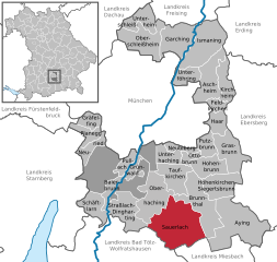
Sauerlach
- municipality of Germany
Hiking in Sauerlach
Sauerlach, located in Bavaria, Germany, near the foothills of the Alps, offers a lovely environment for hiking enthusiasts. While Sauerlach itself is a small town, its proximity to the stunning landscapes of the Bavarian Alps provides a wealth of hiking opportunities suitable for all levels, from casual strolls to challenging alpine treks. Here’s a guide to hiking in and around Sauerlach:...
- Country:
- Postal Code: 82054
- Local Dialing Code: 08104
- Licence Plate Code: M
- Coordinates: 47° 58' 0" N, 11° 39' 0" E
- GPS tracks (wikiloc): [Link]
- AboveSeaLevel: 618 м m
- Area: 48.49 sq km
- Population: 5094
- Web site: [Link]


Unterschleißheim
- town in Bavaria, Germany
Hiking in Unterschleißheim
Unterschleißheim, located just north of Munich in Bavaria, Germany, is a charming area primarily known for its suburban lifestyle but also offers access to several outdoor activities, including hiking. While Unterschleißheim itself may not have extensive trails, it serves as a great base for exploring nearby parks and nature areas....
- Country:
- Postal Code: 85716
- Local Dialing Code: 089
- Licence Plate Code: M
- Coordinates: 48° 17' 0" N, 11° 34' 0" E
- GPS tracks (wikiloc): [Link]
- AboveSeaLevel: 473 м m
- Area: 14.93 sq km
- Population: 20643
- Web site: [Link]
Shares border with regions:

Freising
- district of Bavaria, Germany
Hiking in Freising
Freising, located in Bavaria, Germany, offers a variety of hiking opportunities suitable for different skill levels and preferences. The district is known for its picturesque landscapes, including rolling hills, scenic views, and lush forests. Here are some highlights if you’re considering hiking in Freising:...
- Country:
- Capital: Freising
- Licence Plate Code: FS
- Coordinates: 48° 30' 0" N, 11° 49' 48" E
- GPS tracks (wikiloc): [Link]
- AboveSeaLevel: 433 м m
- Area: 800.00 sq km
- Population: 118518
- Web site: [Link]

Dachau
- district of Bavaria, Germany
Hiking in Dachau
Dachau, located just north of Munich in Bavaria, Germany, is a region rich in history and natural beauty, making it a great destination for hiking. Here are some highlights about hiking in the Dachau district:...
- Country:
- Capital: Dachau
- Licence Plate Code: DAH
- Coordinates: 48° 15' 0" N, 11° 25' 12" E
- GPS tracks (wikiloc): [Link]
- AboveSeaLevel: 506 м m
- Area: 579.00 sq km
- Population: 152703
- Web site: [Link]


Fürstenfeldbruck
- district of Bavaria, Germany
Hiking in Fürstenfeldbruck
Fürstenfeldbruck is a beautiful district located just outside of Munich, Germany, and offers a variety of scenic hiking opportunities. The region is characterized by its rolling hills, lush forests, and picturesque landscapes, making it a great destination for hikers of all skill levels....
- Country:
- Capital: Fürstenfeldbruck
- Licence Plate Code: FFB
- Coordinates: 48° 10' 12" N, 11° 10' 12" E
- GPS tracks (wikiloc): [Link]
- AboveSeaLevel: 550 м m
- Area: 435.00 sq km
- Population: 172760
- Web site: [Link]
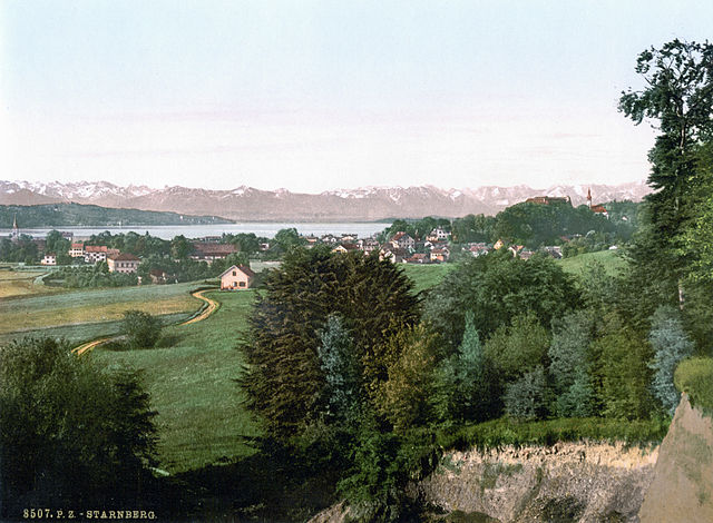
Starnberg
- district of Bavaria, Germany
Hiking in Starnberg
Hiking in the Starnberg district, located in Bavaria, Germany, offers a beautiful blend of scenic landscapes, including lakes, forests, and picturesque villages. Here are some highlights and tips for hiking in the area:...
- Country:
- Capital: Starnberg
- Licence Plate Code: WOR; STA
- Coordinates: 48° 0' 36" N, 11° 16' 48" E
- GPS tracks (wikiloc): [Link]
- AboveSeaLevel: 683 м m
- Area: 488.01 sq km
- Population: 108887
- Web site: [Link]

Bad Tölz-Wolfratshausen
- district of Bavaria, Germany
Hiking in Bad Tölz-Wolfratshausen
Bad Tölz-Wolfratshausen is a picturesque region in Bavaria, Germany, known for its stunning landscapes and excellent hiking opportunities. Nestled in the foothills of the Alps, this area offers a variety of trails that cater to different skill levels, from gentle walks suitable for families to more challenging hikes for experienced adventurers....
- Country:
- Capital: Bad Tölz
- Licence Plate Code: WOR; TÖL
- Coordinates: 47° 45' 0" N, 11° 34' 48" E
- GPS tracks (wikiloc): [Link]
- AboveSeaLevel: 848 м m
- Area: 1111.00 sq km
- Population: 126572
- Web site: [Link]

Miesbach
- district of Bavaria, Germany
Hiking in Miesbach
Miesbach is a scenic district located in Bavaria, Germany, known for its stunning landscapes, rolling hills, and proximity to the Alps. It offers a wealth of hiking opportunities for both beginners and experienced hikers. Here are some highlights about hiking in the Miesbach district:...
- Country:
- Capital: Miesbach
- Licence Plate Code: MB
- Coordinates: 47° 44' 24" N, 11° 48' 36" E
- GPS tracks (wikiloc): [Link]
- AboveSeaLevel: 741 м m
- Area: 864.00 sq km
- Population: 93630
- Web site: [Link]

Rosenheim
- district of Bavaria, Germany
Hiking in Rosenheim
Rosenheim district, located in Bavaria, Germany, offers a diverse range of hiking opportunities amidst beautiful landscapes, charming villages, and stunning natural scenery. Here are some highlights for hiking in the region:...
- Country:
- Capital: Rosenheim
- Licence Plate Code: WS; RO; AIB
- Coordinates: 47° 55' 12" N, 12° 10' 12" E
- GPS tracks (wikiloc): [Link]
- AboveSeaLevel: 512 м m
- Area: 1439.40 sq km
- Population: 190104
- Web site: [Link]

District of Erding
- district of Bavaria, Germany
Hiking in District of Erding
Erding, located in Bavaria, Germany, offers a variety of hiking opportunities for enthusiasts of all skill levels. This district is characterized by its beautiful landscapes, rolling hills, and picturesque villages, making it a wonderful destination for outdoor activities....
- Country:
- Licence Plate Code: ED
- Coordinates: 48° 19' 48" N, 11° 55' 12" E
- GPS tracks (wikiloc): [Link]
- AboveSeaLevel: 480 м m
- Area: 870.44 sq km
- Population: 89190
- Web site: [Link]

Ebersberg
- district of Bavaria, Germany
Hiking in Ebersberg
Ebersberg District, located in Bavaria, Germany, is a fantastic destination for hiking enthusiasts. This region offers a mix of lush forests, rolling hills, picturesque landscapes, and scenic views, making it perfect for both casual walkers and more experienced hikers....
- Country:
- Capital: Ebersberg
- Licence Plate Code: EBE
- Coordinates: 48° 4' 48" N, 11° 55' 12" E
- GPS tracks (wikiloc): [Link]
- AboveSeaLevel: 601 м m
- Area: 549.30 sq km
- Population: 96283
- Web site: [Link]

Munich
- city in Bavaria, Germany
Hiking in Munich
Hiking in Munich offers a fantastic blend of urban and natural experiences. Munich is the capital of Bavaria, situated close to the Alps, which makes it an excellent base for various hikes. Here’s an overview of hiking in and around Munich:...
- Country:
- Postal Code: 81825; 81735; 81730; 81737; 81379; 81377; 80805; 80802; 81929; 80331
- Local Dialing Code: 089
- Licence Plate Code: M
- Coordinates: 48° 8' 14" N, 11° 34' 32" E
- GPS tracks (wikiloc): [Link]
- AboveSeaLevel: 519 м m
- Area: 310.71 sq km
- Population: 1456039
- Web site: [Link]