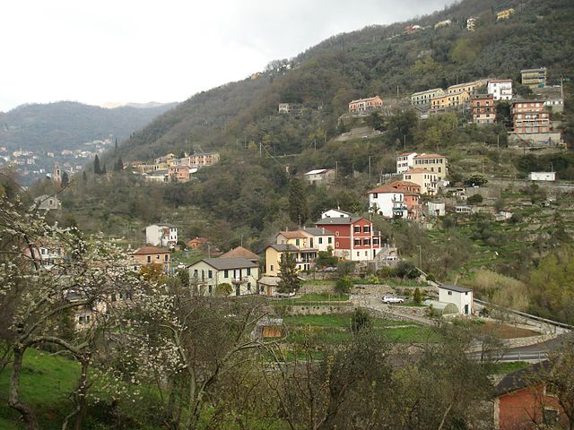
Uscio (Uscio)
.svg)
- Italian comune
 Hiking in Uscio
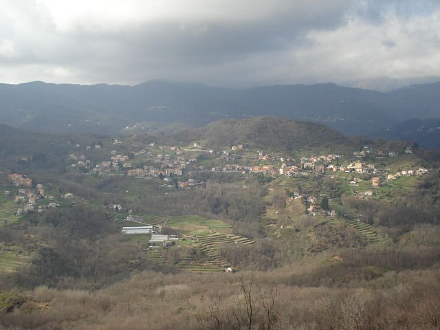
Uscio is a charming municipality located in the Italian region of Liguria, close to the coast and surrounded by picturesque landscapes. The region offers a variety of hiking opportunities that cater to different skill levels, from leisurely walks to more challenging treks.
Hiking Trails Near Uscio:
-
Sentiero dei Parchi: This trail connects various parks in the area and offers beautiful views of the surrounding hills and valleys. It’s great for families and beginners looking for an easy hike.
-
Valle di Uscio: The valleys surrounding Uscio offer numerous trails that allow hikers to explore the natural beauty, traditional villages, and local flora and fauna. The paths are marked, and you can often find signs providing information about the local environment.
-
Monte Fasce: For those looking for a challenge, the hike to Monte Fasce offers stunning panoramic views over the Gulf of Genoa. The trail can be demanding, but the vistas are worth the effort.
-
Trail to the Coastal Towns: Uscio is just a short distance from the coast, and there are trails that take you to charming seaside towns like Recco or Camogli. These routes provide a mix of coastal and hilly terrain.
Tips for Hiking in Uscio:
-
Proper Footwear: Make sure to wear sturdy, comfortable hiking shoes, especially if tackling steeper or rocky trails.
-
Hydration: Carry enough water, particularly during warmer months, as some trails may not have readily available water sources.
-
Local Maps: While many trails are marked, having a detailed map can greatly enhance your hiking experience. Local tourist information centers can provide maps and additional details about the trails.
-
Weather Awareness: The weather can change quickly in the Liguria mountains, so check forecasts before heading out and be prepared with appropriate clothing.
-
Wildlife and Nature: Keep an eye out for local wildlife and respect the natural environment. Stay on marked paths to minimize impact on the surroundings.
Safety Considerations:
- Always inform someone of your hiking plans and expected return time, especially if exploring less populated trails.
- If hiking alone, it’s crucial to stay on well-marked paths and have a means of navigation.
Conclusion:
Hiking in Uscio can be a rewarding experience, combining physical activity with the opportunity to enjoy stunning natural landscapes and cultural sites. Whether you're an experienced hiker or a beginner looking for a peaceful stroll, Uscio has trails to suit your needs. Enjoy your time exploring this beautiful part of Italy!
- Country:

- Postal Code: 16036
- Local Dialing Code: 0185
- Licence Plate Code: GE
- Coordinates: 44° 24' 48" N, 9° 9' 47" E


- GPS tracks (wikiloc): [Link]
- AboveSeaLevel: 361 м m
- Area: 9.63 sq km
- Population: 2222
- Web site: http://www.comune.uscio.ge.it
- Wikipedia en: wiki(en)
- Wikipedia: wiki(it)
- Wikidata storage: Wikidata: Q266666
- Wikipedia Commons Category: [Link]
- Freebase ID: [/m/0ghx0d]
- GeoNames ID: Alt: [6536103]
- VIAF ID: Alt: [138461315]
- OSM relation ID: [43139]
- ISTAT ID: 010064
- Italian cadastre code: L507
Shares border with regions:

Avegno, Liguria
- Italian comune
Hiking in Avegno, Liguria
Avegno is a charming village located in the Liguria region of Italy, nestled in the scenic hills near the coast. It offers a variety of hiking opportunities, perfect for both beginners and experienced hikers. Here are some details about hiking in and around Avegno:...
- Country:
- Postal Code: 16036
- Local Dialing Code: 0185
- Licence Plate Code: GE
- Coordinates: 44° 22' 56" N, 9° 9' 31" E
- GPS tracks (wikiloc): [Link]
- AboveSeaLevel: 34 м m
- Area: 10.93 sq km
- Population: 2504
- Web site: [Link]


Sori
- Italian comune
Hiking in Sori
Sori, a charming coastal town in Liguria, Italy, is nestled between the lush hills of the Italian Riviera and the sparkling Ligurian Sea. It offers a wealth of hiking opportunities for outdoor enthusiasts looking to explore the dramatic landscapes, picturesque views, and the region’s natural beauty....
- Country:
- Postal Code: 16031
- Local Dialing Code: 0185
- Licence Plate Code: GE
- Coordinates: 44° 22' 22" N, 9° 6' 15" E
- GPS tracks (wikiloc): [Link]
- AboveSeaLevel: 14 м m
- Area: 13.07 sq km
- Population: 4176
- Web site: [Link]

Lumarzo
- Italian comune
Hiking in Lumarzo
Lumarzo is a charming village located in the Liguria region of Italy, near the eastern side of the Mediterranean coast. It is surrounded by beautiful natural landscapes, making it an excellent spot for hiking enthusiasts. The area features scenic trails that take you through lush forests, vineyards, and offer stunning views of the surrounding hills and valleys....
- Country:
- Postal Code: 16024
- Local Dialing Code: 0185
- Licence Plate Code: GE
- Coordinates: 44° 26' 37" N, 9° 8' 14" E
- GPS tracks (wikiloc): [Link]
- AboveSeaLevel: 325 м m
- Area: 25.51 sq km
- Population: 1527
- Web site: [Link]


Neirone
- Italian comune
Hiking in Neirone
Neirone is a charming village located in the Metropolitan City of Genoa, in the Liguria region of Italy. Nestled in the Italian Alps, it offers a beautiful landscape for hiking enthusiasts. Here's a quick overview of what you can expect when hiking in Neirone:...
- Country:
- Postal Code: 16040
- Local Dialing Code: 0185
- Licence Plate Code: GE
- Coordinates: 44° 27' 15" N, 9° 11' 27" E
- GPS tracks (wikiloc): [Link]
- AboveSeaLevel: 350 м m
- Area: 30.24 sq km
- Population: 849
- Web site: [Link]


Tribogna
- Italian comune
Hiking in Tribogna
Tribogna is a picturesque village located in the Liguria region of Italy, nestled along the stunning coastline near the Cinque Terre. While it's not as widely known as its neighboring towns, Tribogna offers several charming hiking opportunities for outdoor enthusiasts looking to explore the area's natural beauty....
- Country:
- Postal Code: 16030
- Local Dialing Code: 0185
- Licence Plate Code: GE
- Coordinates: 44° 24' 59" N, 9° 11' 45" E
- GPS tracks (wikiloc): [Link]
- AboveSeaLevel: 330 м m
- Area: 7.14 sq km
- Population: 598
- Web site: [Link]