Vacognes-Neuilly (Vacognes-Neuilly)

- commune in Calvados, France
- Country:

- Postal Code: 14210
- Coordinates: 49° 4' 29" N, 0° 31' 30" E


- GPS tracks (wikiloc): [Link]
- AboveSeaLevel: 134 м m
- Area: 7.9 sq km
- Population: 584
- Wikipedia en: wiki(en)
- Wikipedia: wiki(fr)
- Wikidata storage: Wikidata: Q267540
- Wikipedia Commons Category: [Link]
- Freebase ID: [/m/01j303]
- GeoNames ID: Alt: [6615923]
- SIREN number: [211407218]
- BnF ID: [15248129z]
- INSEE municipality code: 14721
Shares border with regions:

Bougy
- commune in Calvados, France
- Country:
- Postal Code: 14210
- Coordinates: 49° 6' 43" N, 0° 31' 27" E
- GPS tracks (wikiloc): [Link]
- Area: 3.03 sq km
- Population: 405
- Web site: [Link]

Évrecy
- commune in Calvados, France
- Country:
- Postal Code: 14210
- Coordinates: 49° 5' 59" N, 0° 30' 12" E
- GPS tracks (wikiloc): [Link]
- Area: 8.31 sq km
- Population: 2024
- Web site: [Link]


Sainte-Honorine-du-Fay
- commune in Calvados, France
- Country:
- Postal Code: 14210
- Coordinates: 49° 4' 39" N, 0° 29' 33" E
- GPS tracks (wikiloc): [Link]
- Area: 7.56 sq km
- Population: 1332
- Web site: [Link]

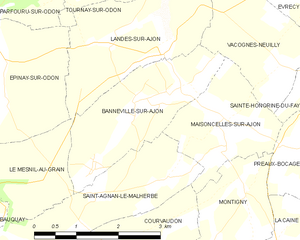
Banneville-sur-Ajon
- former commune in Calvados, France
- Country:
- Postal Code: 14260
- Coordinates: 49° 3' 46" N, 0° 34' 11" E
- GPS tracks (wikiloc): [Link]
- Area: 5.63 sq km
- Population: 415


Maisoncelles-sur-Ajon
- commune in Calvados, France
- Country:
- Postal Code: 14210
- Coordinates: 49° 3' 14" N, 0° 32' 19" E
- GPS tracks (wikiloc): [Link]
- Area: 4.24 sq km
- Population: 192


Landes-sur-Ajon
- commune in Calvados, France
- Country:
- Postal Code: 14310
- Coordinates: 49° 4' 33" N, 0° 34' 47" E
- GPS tracks (wikiloc): [Link]
- Area: 6 sq km
- Population: 406


Tournay-sur-Odon
- former commune in Calvados, France
- Country:
- Postal Code: 14310
- Coordinates: 49° 5' 28" N, 0° 35' 16" E
- GPS tracks (wikiloc): [Link]
- Area: 6.93 sq km
- Population: 357


Le Locheur
- former commune in Calvados, France
- Country:
- Postal Code: 14210
- Coordinates: 49° 6' 14" N, 0° 33' 9" E
- GPS tracks (wikiloc): [Link]
- Area: 3.68 sq km
- Population: 260