Valbeleix (Valbeleix)

- commune in Puy-de-Dôme, France
- Country:

- Postal Code: 63610
- Coordinates: 45° 28' 8" N, 2° 59' 14" E


- GPS tracks (wikiloc): [Link]
- Area: 22.41 sq km
- Population: 134
- Wikipedia en: wiki(en)
- Wikipedia: wiki(fr)
- Wikidata storage: Wikidata: Q1046874
- Wikipedia Commons Category: [Link]
- Freebase ID: [/m/03ql5j2]
- GeoNames ID: Alt: [6440260]
- SIREN number: [216304402]
- BnF ID: [15269790b]
- INSEE municipality code: 63440
Shares border with regions:

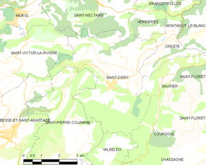
Saint-Diéry
- commune in Puy-de-Dôme, France
- Country:
- Postal Code: 63320
- Coordinates: 45° 32' 42" N, 3° 1' 13" E
- GPS tracks (wikiloc): [Link]
- Area: 24.11 sq km
- Population: 403

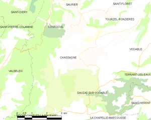
Chassagne
- commune in Puy-de-Dôme, France
- Country:
- Postal Code: 63320
- Coordinates: 45° 29' 52" N, 3° 4' 35" E
- GPS tracks (wikiloc): [Link]
- Area: 16.06 sq km
- Population: 71


Courgoul
- commune in Puy-de-Dôme, France
- Country:
- Postal Code: 63320
- Coordinates: 45° 30' 50" N, 3° 2' 19" E
- GPS tracks (wikiloc): [Link]
- Area: 8.44 sq km
- Population: 73

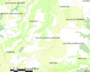
Roche-Charles-la-Mayrand
- commune in Puy-de-Dôme, France
- Country:
- Postal Code: 63420
- Coordinates: 45° 27' 31" N, 3° 1' 49" E
- GPS tracks (wikiloc): [Link]
- AboveSeaLevel: 900 м m
- Area: 16.22 sq km
- Population: 42


Besse-et-Saint-Anastaise
- commune in Puy-de-Dôme, France
- Country:
- Postal Code: 63610
- Coordinates: 45° 30' 47" N, 2° 55' 58" E
- GPS tracks (wikiloc): [Link]
- Area: 72.38 sq km
- Population: 1502
- Web site: [Link]


Compains
- commune in Puy-de-Dôme, France
- Country:
- Postal Code: 63610
- Coordinates: 45° 26' 29" N, 2° 55' 40" E
- GPS tracks (wikiloc): [Link]
- Area: 50.16 sq km
- Population: 122


Saint-Pierre-Colamine
- commune in Puy-de-Dôme, France
- Country:
- Postal Code: 63610
- Coordinates: 45° 31' 50" N, 2° 58' 28" E
- GPS tracks (wikiloc): [Link]
- Area: 17.2 sq km
- Population: 250