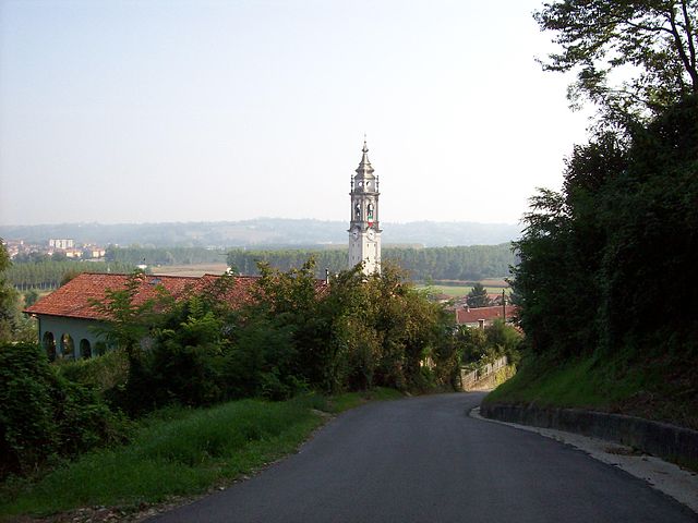
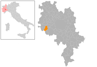
Valfenera (Valfenera)

- Italian comune
 Hiking in Valfenera
Valfenera, located in the Piedmont region of Italy, offers scenic landscapes and a variety of outdoor activities, including hiking. Although it may not be as widely known as some other hiking hotspots, it has its own charm with rolling hills, vineyards, and picturesque rural settings.
Hiking Trails
-
Local Trails: There are several local trails around Valfenera that allow you to explore the beautiful countryside and enjoy the views of the vineyards and hills. These paths vary in difficulty, making them suitable for both beginners and experienced hikers.
-
The Greenway of the Po: This trail runs along the Po River and provides a longer hiking option for those wanting to experience more extensive natural beauty. You can access parts of the Greenway from Valfenera, connecting you to wider hiking networks.
-
Barbaresco and Langhe Trails: A short drive from Valfenera, these trails wind through famous wine regions and typically offer well-marked paths with stunning views of vineyards. They also provide opportunities to sample local wine and cuisine along the way.
Tips for Hiking in Valfenera
-
Weather: Be sure to check the weather before heading out, as conditions can change rapidly. Spring and autumn are ideal for hiking due to mild temperatures.
-
Local Guidance: Consider seeking local hiking maps or joining a guided tour to discover hidden gems and learn about the area's natural and cultural history.
-
Footwear: Wear sturdy hiking boots, especially on uneven terrain. Some paths can be rocky or muddy.
-
Hydration and Snacks: Carry sufficient water and snacks, especially for longer hikes. You may not find facilities along all trails.
-
Respect Nature: Follow Leave No Trace principles to keep the area clean and preserve its beauty for future visitors.
Cultural Aspects
While hiking, you may also encounter charming villages and historical sites, which can enrich your experience. It's an excellent opportunity to immerse yourself in local culture and traditions.
Overall, hiking in Valfenera can be a delightful experience, especially for those who appreciate a blend of nature and wine country scenery.
- Country:

- Postal Code: 14017
- Local Dialing Code: 0141
- Licence Plate Code: AT
- Coordinates: 44° 54' 10" N, 7° 57' 55" E


- GPS tracks (wikiloc): [Link]
- AboveSeaLevel: 282 м m
- Area: 22.04 sq km
- Population: 2464
- Web site: http://www.comune.valfenera.at.it/
- Wikipedia en: wiki(en)
- Wikipedia: wiki(it)
- Wikidata storage: Wikidata: Q17876
- Freebase ID: [/m/0gbjn7]
- GeoNames ID: Alt: [6538182]
- VIAF ID: Alt: [241189304]
- OSM relation ID: [43736]
- UN/LOCODE: [ITVAA]
- ISTAT ID: 005112
- Italian cadastre code: L574
Shares border with regions:

Cantarana
- Italian comune
Hiking in Cantarana
Cantarana is not widely known as a hiking destination, so it’s possible you might be referring to a specific local area, regional name, or perhaps a hiking trail within a larger known park or mountainous region. However, there are several general tips and suggestions for hiking in any area, which I can provide:...
- Country:
- Postal Code: 14010
- Local Dialing Code: 0141
- Licence Plate Code: AT
- Coordinates: 44° 54' 12" N, 8° 1' 43" E
- GPS tracks (wikiloc): [Link]
- AboveSeaLevel: 176 м m
- Area: 9.72 sq km
- Population: 1015
- Web site: [Link]
Cellarengo
- Italian comune
Hiking in Cellarengo
Cellarengo is a small town located in the Piedmont region of Italy, and while it might not be widely known for hiking specifically, there are opportunities to explore the natural beauty of the surrounding area. The region is characterized by rolling hills, vineyards, and picturesque landscapes typical of Piedmont....
- Country:
- Postal Code: 14010
- Local Dialing Code: 0141
- Licence Plate Code: AT
- Coordinates: 44° 51' 55" N, 7° 56' 47" E
- GPS tracks (wikiloc): [Link]
- AboveSeaLevel: 321 м m
- Area: 10.85 sq km
- Population: 700
- Web site: [Link]
Dusino San Michele
- Italian comune
Hiking in Dusino San Michele
Dusino San Michele is a small municipality located in the Piedmont region of Italy. While it may not be as widely known as major hiking destinations, it can offer charming walking paths and scenic nature for those looking for a more tranquil outdoor experience....
- Country:
- Postal Code: 14010
- Local Dialing Code: 0141
- Licence Plate Code: AT
- Coordinates: 44° 54' 51" N, 7° 58' 19" E
- GPS tracks (wikiloc): [Link]
- AboveSeaLevel: 264 м m
- Area: 11.93 sq km
- Population: 1047
- Web site: [Link]

Ferrere
- Italian comune
Hiking in Ferrere
Ferrere is a quaint location in Italy, offering scenic views and various hiking trails that cater to a range of skill levels. Though Ferrere itself may not be a prominent hiking destination like larger national parks or mountainous regions, its surrounding areas, especially in the Piedmont region, offer some lovely opportunities for outdoor enthusiasts....
- Country:
- Postal Code: 14012
- Local Dialing Code: 0141
- Licence Plate Code: AT
- Coordinates: 44° 52' 34" N, 7° 59' 39" E
- GPS tracks (wikiloc): [Link]
- AboveSeaLevel: 268 м m
- Area: 13.93 sq km
- Population: 1586
- Web site: [Link]


Villanova d'Asti
- Italian comune
Hiking in Villanova d'Asti
Villanova d'Asti, located in the Piedmont region of Italy, offers a range of scenic hiking opportunities with its rolling hills, vineyards, and picturesque landscapes. Here are some highlights and tips for hiking in this area:...
- Country:
- Postal Code: 14019
- Local Dialing Code: 0141
- Licence Plate Code: AT
- Coordinates: 44° 56' 34" N, 7° 56' 18" E
- GPS tracks (wikiloc): [Link]
- AboveSeaLevel: 260 м m
- Area: 41.95 sq km
- Population: 5686
- Web site: [Link]

Montà
- Italian comune
Hiking in Montà
Montà, located in the Piedmont region of Italy, is known for its picturesque landscapes, rolling hills, and vineyards, making it a charming destination for hiking enthusiasts. Here are some highlights and tips for hiking in Montà:...
- Country:
- Postal Code: 12046
- Local Dialing Code: 0173
- Licence Plate Code: CN
- Coordinates: 44° 48' 53" N, 7° 57' 17" E
- GPS tracks (wikiloc): [Link]
- AboveSeaLevel: 316 м m
- Area: 26.82 sq km
- Population: 4712
- Web site: [Link]
Isolabella
- Italian comune
Hiking in Isolabella
Isolabella, located in the province of Turin, offers a picturesque backdrop for hiking enthusiasts. While Isolabella itself is a small municipality, it's within proximity to various trails and natural areas in the surrounding region, particularly in the Susa Valley and the nearby Olympic Mountains....
- Country:
- Postal Code: 10046
- Local Dialing Code: 011
- Licence Plate Code: TO
- Coordinates: 44° 54' 0" N, 7° 55' 0" E
- GPS tracks (wikiloc): [Link]
- AboveSeaLevel: 256 м m
- Area: 4.77 sq km
- Population: 380
- Web site: [Link]