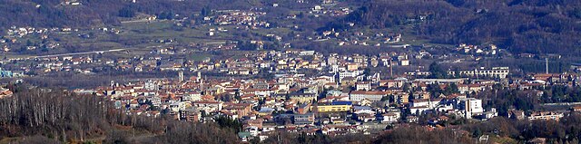
Valperga (Valperga)

- Italian comune
 Hiking in Valperga
Valperga is a charming town located in the Piedmont region of Italy, nestled in the Canavese area, which offers a variety of hiking opportunities in its picturesque landscapes characterized by rolling hills, lush forests, and stunning views of the surrounding mountains.
Hiking Highlights in Valperga:
-
Scenic Trails: The region is home to numerous trails that cater to different levels of hikers, from easy walks to more challenging routes. The trails often take you through scenic spots with opportunities to explore local flora and fauna.
-
Local Geographical Features: The surrounding area includes the Sierra di Bessa Natural Park, known for its rich biodiversity and historical significance. Hiking here allows you to explore ancient ruins and enjoy breathtaking views.
-
Cultural Hikes: Some trails connect to historical sites such as castles and ancient villages, providing a unique blend of nature and culture. The Castle of Valperga is a notable landmark that can be reached on foot.
-
Recommendations:
- Beginner’s Trail: If you're new to hiking, consider short trails around the town that offer gentle gradients and picturesque views.
- Intermediate and Advanced Hikes: More experienced hikers can tackle the higher elevation trails that lead to panoramic viewpoints over the Canavese Valley and the Alps.
-
Seasonal Considerations: Spring and autumn are ideal for hiking in Valperga due to mild weather, while summer can be warm. Winter hikes may require proper gear, especially if snow is present.
-
Safety Tips: Always carry water, wear appropriate footwear, and check trail conditions before setting out. It's advisable to inform someone about your hiking plans and expected return time.
Additional Activities:
Apart from hiking, the area around Valperga offers opportunities for cycling, birdwatching, and exploring local cuisine in nearby restaurants and cafes.
Final Note:
Valperga’s serene environment and stunning natural beauty make it a wonderful destination for hiking enthusiasts. Whether you're looking for a leisurely walk or a more challenging excursion, there's something for everyone to enjoy in this picturesque Italian region.
- Country:

- Postal Code: 10087
- Local Dialing Code: 0124
- Licence Plate Code: TO
- Coordinates: 45° 22' 0" N, 7° 39' 0" E


- GPS tracks (wikiloc): [Link]
- Area: 11.91 sq km
- Population: 3102
- Web site: http://www.comune.valperga.to.it
- Wikipedia en: wiki(en)
- Wikipedia: wiki(it)
- Wikidata storage: Wikidata: Q10335
- Wikipedia Commons Category: [Link]
- Freebase ID: [/m/0g8mqw]
- GeoNames ID: Alt: [6538090]
- VIAF ID: Alt: [249251013]
- OSM relation ID: [44799]
- UN/LOCODE: [ITVPA]
- ISTAT ID: 001287
- Italian cadastre code: L644
Shares border with regions:


Prascorsano
- Italian comune
Hiking in Prascorsano
Prascorsano is a picturesque village located in the Piedmont region of Italy, nestled in the foothills of the Alps. It offers beautiful landscapes and a rich natural environment, making it an attractive destination for hiking enthusiasts. Here are some highlights and tips for hiking in and around Prascorsano:...
- Country:
- Postal Code: 10080
- Local Dialing Code: 0124
- Licence Plate Code: TO
- Coordinates: 45° 22' 0" N, 7° 37' 0" E
- GPS tracks (wikiloc): [Link]
- AboveSeaLevel: 590 м m
- Area: 6.24 sq km
- Population: 747
- Web site: [Link]
Pratiglione
- Italian comune
Hiking in Pratiglione
Pratiglione is a scenic area located in the Piedmont region of Italy, known for its natural beauty and outdoor recreational opportunities. Here are some key points to consider if you’re planning to hike in Pratiglione:...
- Country:
- Postal Code: 10080
- Local Dialing Code: 0124
- Licence Plate Code: TO
- Coordinates: 45° 21' 0" N, 7° 36' 0" E
- GPS tracks (wikiloc): [Link]
- AboveSeaLevel: 611 м m
- Area: 7.88 sq km
- Population: 511
- Web site: [Link]


Rivara
- Italian comune
Hiking in Rivara
Rivara, located in the Piedmont region of Italy, offers a scenic backdrop for hikers with its beautiful landscapes, rolling hills, and rich cultural heritage. While Rivara may not be as widely known as more prominent hiking destinations, it provides a charming experience for those looking to explore the area on foot....
- Country:
- Postal Code: 10080
- Local Dialing Code: 0124
- Licence Plate Code: TO
- Coordinates: 45° 19' 50" N, 7° 38' 56" E
- GPS tracks (wikiloc): [Link]
- AboveSeaLevel: 392 м m
- Area: 12.58 sq km
- Population: 2606
- Web site: [Link]


Salassa
- Italian comune
Hiking in Salassa
Salassa is a quaint municipality in the province of Turin, Italy, nestled in the picturesque Piedmont region. While it may not be as commonly recognized as a major hiking destination, the surrounding areas offer some beautiful trails and opportunities for outdoor enthusiasts....
- Country:
- Postal Code: 10080
- Local Dialing Code: 0124
- Licence Plate Code: TO
- Coordinates: 45° 22' 0" N, 7° 41' 0" E
- GPS tracks (wikiloc): [Link]
- AboveSeaLevel: 361 м m
- Area: 4.95 sq km
- Population: 1840
- Web site: [Link]


San Ponso
- Italian comune
Hiking in San Ponso
San Ponso, located in the Piedmont region of Italy, offers some wonderful hiking opportunities, particularly for those looking to explore the natural beauty of the surrounding area. Here are some key points to consider when planning a hiking trip in San Ponso:...
- Country:
- Postal Code: 10080
- Local Dialing Code: 0124
- Licence Plate Code: TO
- Coordinates: 45° 21' 0" N, 7° 40' 0" E
- GPS tracks (wikiloc): [Link]
- AboveSeaLevel: 347 м m
- Area: 2.12 sq km
- Population: 263
- Web site: [Link]


Busano
- Italian comune
Hiking in Busano
Busano is a charming municipality located in the province of Turin, Italy, and is known for its beautiful natural landscapes and outdoor activities, including hiking. Nestled in the foothills of the Alps, Busano offers a variety of trails that cater to different skill levels, making it an ideal destination for both novice and experienced hikers....
- Country:
- Postal Code: 10080
- Local Dialing Code: 0124
- Licence Plate Code: TO
- Coordinates: 45° 20' 0" N, 7° 39' 0" E
- GPS tracks (wikiloc): [Link]
- AboveSeaLevel: 317 м m
- Area: 5.06 sq km
- Population: 1642
- Web site: [Link]


Castellamonte
- Italian comune
Hiking in Castellamonte
Castellamonte is a picturesque town located in the province of Turin, in the Piemonte region of Italy. The surrounding area offers a variety of hiking opportunities for both beginners and experienced hikers. Here are some insights into hiking in and around Castellamonte:...
- Country:
- Postal Code: 10081
- Local Dialing Code: 0124
- Licence Plate Code: TO
- Coordinates: 45° 22' 55" N, 7° 42' 38" E
- GPS tracks (wikiloc): [Link]
- AboveSeaLevel: 343 м m
- Area: 38.71 sq km
- Population: 9977
- Web site: [Link]

Cuorgnè
- Italian comune
Hiking in Cuorgnè
Cuorgnè, located in the Piedmont region of Italy, is surrounded by stunning landscapes that offer numerous hiking opportunities. Positioned near the foothills of the Alps, the area is known for its diverse terrain, which includes hills, forests, and panoramic viewpoints....
- Country:
- Postal Code: 10082
- Local Dialing Code: 0124
- Licence Plate Code: TO
- Coordinates: 45° 23' 0" N, 7° 39' 0" E
- GPS tracks (wikiloc): [Link]
- AboveSeaLevel: 414 м m
- Area: 19.31 sq km
- Population: 9728
- Web site: [Link]
Pertusio
- Italian comune
Hiking in Pertusio
Pertusio is a charming village located in the Susa Valley of the Piedmont region in northern Italy. It's a great destination for outdoor enthusiasts, particularly those who enjoy hiking. The area is characterized by beautiful landscapes, rugged mountains, and serene alpine environments. Here are some highlights and tips for hiking in and around Pertusio:...
- Country:
- Postal Code: 10080
- Local Dialing Code: 0124
- Licence Plate Code: TO
- Coordinates: 45° 21' 0" N, 7° 38' 0" E
- GPS tracks (wikiloc): [Link]
- AboveSeaLevel: 364 м m
- Area: 4 sq km
- Population: 763
- Web site: [Link]