Vaufrey (Vaufrey)

- commune in Doubs, France
 Hiking in Vaufrey
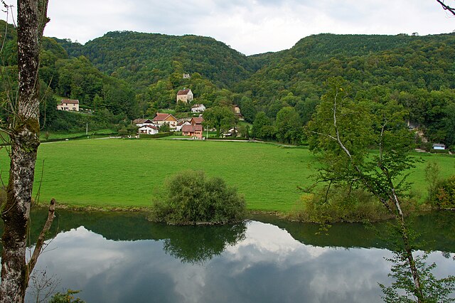
Vaufrey is a picturesque area located in the Doubs department of the Bourgogne-Franche-Comté region in eastern France. Although it may not be as widely known as some other hiking destinations, it offers beautiful landscapes and a variety of outdoor activities for nature enthusiasts.
Hiking Opportunities in Vaufrey:
-
Scenic Trails: The region features several hiking trails that cater to different skill levels. You can enjoy peaceful walks through forests, along rivers, and across rolling hills.
-
Natural Beauty: Vaufrey is surrounded by lush greenery, hills, and picturesque views. The Doubs valley and nearby hills provide a beautiful backdrop for hiking, with opportunities to see diverse flora and fauna.
-
Historical Sites: While hiking, you may encounter historical sites and charming villages, allowing you to experience the local culture and history.
-
Wildlife Watching: The area is home to various wildlife, including deer, birds, and other small animals. Birdwatchers and wildlife enthusiasts will find plenty to enjoy.
-
St. Hippolyte and Nearby Areas: The close proximity to St. Hippolyte and other neighboring towns offers additional hiking routes and attractions.
Tips for Hiking in Vaufrey:
- Prepare for the Terrain: Some trails may vary in difficulty, so it's important to wear appropriate footwear and be mindful of the weather conditions.
- Hydration and Nutrition: Bring plenty of water and snacks, especially if you plan on hiking for several hours.
- Local Maps: Consider obtaining a local hiking map or guide to help you navigate the trails.
- Respect Nature: Always follow the principles of Leave No Trace, ensuring you keep the natural environment clean and preserve the beauty of the area.
Whether you are seeking a peaceful day hike or a more challenging trek, Vaufrey offers a nice opportunity to explore the natural beauty of eastern France. Enjoy your hiking adventure!
- Country:

- Postal Code: 25190
- Coordinates: 47° 20' 53" N, 6° 55' 27" E


- GPS tracks (wikiloc): [Link]
- Area: 9.37 sq km
- Population: 158
- Wikipedia en: wiki(en)
- Wikipedia: wiki(fr)
- Wikidata storage: Wikidata: Q175804
- Wikipedia Commons Category: [Link]
- Freebase ID: [/m/03mhdzg]
- GeoNames ID: Alt: [6430033]
- SIREN number: [212505911]
- BnF ID: [15252817n]
- VIAF ID: Alt: [243850702]
- INSEE municipality code: 25591
Shares border with regions:


Courtefontaine
- commune in Doubs, France
Hiking in Courtefontaine
Courtefontaine is a charming village located in the Doubs department of the Bourgogne-Franche-Comté region in eastern France. This area is known for its natural beauty, rich history, and outdoor activities, making it an excellent destination for hikers....
- Country:
- Postal Code: 25470
- Coordinates: 47° 19' 14" N, 6° 54' 29" E
- GPS tracks (wikiloc): [Link]
- Area: 7.7 sq km
- Population: 249

Montjoie-le-Château
- commune in Doubs, France
Hiking in Montjoie-le-Château
Montjoie-le-Château is a charming area located in the Vosges region of France, known for its picturesque landscapes, rich history, and opportunities for outdoor activities, including hiking. The region boasts a variety of trails that cater to different skill levels, offering scenic views of forests, mountains, and the historic remnants of ancient fortifications....
- Country:
- Postal Code: 25190
- Coordinates: 47° 21' 0" N, 6° 54' 7" E
- GPS tracks (wikiloc): [Link]
- Area: 5.39 sq km
- Population: 30

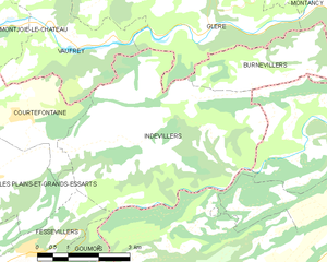
Indevillers
- commune in Doubs, France
Hiking in Indevillers
Indevillers, located in the picturesque region of France, offers a charming backdrop for hiking enthusiasts. Although it may not be as widely known as some larger tourist destinations, it is surrounded by stunning natural landscapes that make it a delightful spot for those looking to explore the great outdoors....
- Country:
- Postal Code: 25470
- Coordinates: 47° 18' 45" N, 6° 57' 25" E
- GPS tracks (wikiloc): [Link]
- Area: 22.81 sq km
- Population: 241


Glère
- commune in Doubs, France
Hiking in Glère
Hiking in the Glère area, particularly around the Glère Mountain in the French Alps, offers a fantastic opportunity for outdoor enthusiasts to experience stunning landscapes, diverse wildlife, and various trail options. Here are some key points to consider if you're planning a hike there:...
- Country:
- Postal Code: 25190
- Coordinates: 47° 20' 37" N, 6° 59' 39" E
- GPS tracks (wikiloc): [Link]
- Area: 15.93 sq km
- Population: 223