Vence (Vence)
- commune in Alpes-Maritimes, France
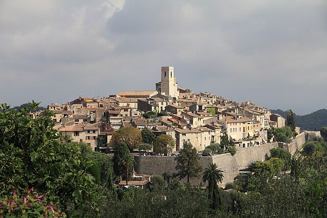
Vence, located in the Provence-Alpes-Côte d'Azur region of France, offers a fantastic blend of coastal and mountainous hiking experiences. Here are some highlights and tips for hiking in and around Vence:
Trail Recommendations
-
Colline du Belvedere: This scenic hike offers panoramic views of the surrounding areas and the Mediterranean Sea. The path meanders through various terrains, giving you a taste of the region's diverse landscapes.
-
Baou de Saint-Jeannet: Just a short drive from Vence, this trail leads you to the summit of Baou de Saint-Jeannet. The hike is moderately challenging but rewards you with stunning vistas of Vence, the coast, and the nearby mountains.
-
Les Gorges du Loup: A bit further from Vence, this is a beautiful hike along the Loup River, featuring waterfalls and unique rock formations. It’s ideal for those who enjoy river scenery and want a cooler hike during the summer.
-
Côte d'Azur Coastal Path: If you’re willing to travel a little farther, hiking along the coastal paths between Nice and Antibes offers breathtaking views of the Mediterranean and charming coastal towns.
Tips for Hiking in Vence
-
Weather: The best hiking months are typically from spring to early autumn (April to October). Summers can be quite warm, so plan early hikes to avoid the heat.
-
Footwear: Good hiking boots or sturdy shoes are recommended, as some trails can be rocky and steep.
-
Water and Snacks: Always carry sufficient water and some snacks, especially on longer trails, as facilities might be limited.
-
Navigation: While many trails are well-marked, having a map or a GPS app can be helpful, particularly in more remote areas.
-
Local Resources: Consider stopping by the local tourist office in Vence for maps, trail recommendations, and current conditions.
-
Respect Nature: Follow the Leave No Trace principles to protect the environment. Stay on marked paths and respect local wildlife.
Points of Interest
-
Vence Village: Take some time to explore the charming old town of Vence, with its narrow streets, historical buildings, and vibrant art scene. It’s a great place to enjoy a meal or relax after a hike.
-
Cultural Sites: Don’t miss the Chapelle du Rosaire, designed by Henri Matisse, and the ancient ramparts that give Vence its historical charm.
Whether you're an experienced hiker or a beginner, Vence offers beautiful trails and breathtaking views that make for an unforgettable hiking experience. Enjoy your adventures in this stunning part of France!
- Country:

- Postal Code: 06140
- Coordinates: 43° 43' 21" N, 7° 6' 43" E


- GPS tracks (wikiloc): [Link]
- Area: 39.23 sq km
- Population: 18393
- Web site: http://www.vence.fr
- Wikipedia en: wiki(en)
- Wikipedia: wiki(fr)
- Wikidata storage: Wikidata: Q192368
- Wikipedia Commons Category: [Link]
- Freebase ID: [/m/07jkg4]
- Freebase ID: [/m/07jkg4]
- GeoNames ID: Alt: [2970148]
- GeoNames ID: Alt: [2970148]
- SIREN number: [210601571]
- SIREN number: [210601571]
- BnF ID: [119428789]
- BnF ID: [119428789]
- VIAF ID: Alt: [261263046]
- VIAF ID: Alt: [261263046]
- GND ID: Alt: [4119386-6]
- GND ID: Alt: [4119386-6]
- archINFORM location ID: [704]
- archINFORM location ID: [704]
- PACTOLS thesaurus ID: [pcrtHJgFGXpsYE]
- PACTOLS thesaurus ID: [pcrtHJgFGXpsYE]
- MusicBrainz area ID: [2ea973d7-f451-44a3-ad8a-a369bba267b5]
- MusicBrainz area ID: [2ea973d7-f451-44a3-ad8a-a369bba267b5]
- Digital Atlas of the Roman Empire ID: [182]
- Digital Atlas of the Roman Empire ID: [182]
- NKCR AUT ID: [ge887070]
- NKCR AUT ID: [ge887070]
- Pleiades ID: [157952]
- Pleiades ID: [157952]
- INSEE municipality code: 06157
- INSEE municipality code: 06157
Shares border with regions:


Cagnes-sur-Mer
- commune in Alpes-Maritimes, France
Cagnes-sur-Mer, located on the French Riviera, offers a delightful blend of coastal beauty and nearby mountainous terrain, making it a geat destination for hiking enthusiasts. Here are some highlights and tips for hiking in and around Cagnes-sur-Mer:...
- Country:

- Postal Code: 06800
- Coordinates: 43° 39' 49" N, 7° 8' 54" E


- GPS tracks (wikiloc): [Link]
- AboveSeaLevel: 93 м m
- Area: 17.95 sq km
- Population: 49322
- Web site: [Link]


Saint-Paul-de-Vence
- commune in Alpes-Maritimes, France
Saint-Paul-de-Vence is a picturesque village located in the Alpes-Maritimes department of France, near the French Riviera. Known for its stunning views, charming cobblestone streets, and rich artistic heritage, it also offers some delightful hiking opportunities in the surrounding hills and countryside....
- Country:

- Postal Code: 06570
- Coordinates: 43° 41' 47" N, 7° 7' 20" E


- GPS tracks (wikiloc): [Link]
- Area: 7.26 sq km
- Population: 3451
- Web site: [Link]


La Gaude
- commune in Alpes-Maritimes, France
La Gaude is a charming village located in the Alpes-Maritimes department in the Provence-Alpes-Côte d'Azur region of France. Nestled in the hills near the French Riviera, it offers beautiful landscapes, picturesque views, and a range of hiking opportunities for outdoor enthusiasts....
- Country:

- Postal Code: 06610
- Coordinates: 43° 43' 19" N, 7° 9' 11" E


- GPS tracks (wikiloc): [Link]
- AboveSeaLevel: 236 м m
- Area: 13.1 sq km
- Population: 6415
- Web site: [Link]


Tourrettes-sur-Loup
- commune in Alpes-Maritimes, France
Tourrettes-sur-Loup is a charming medieval village located in the French Riviera, known for its stunning views and picturesque scenery. The area offers a variety of hiking opportunities, catering to different skill levels. Here are some highlights for hiking in and around Tourrettes-sur-Loup:...
- Country:

- Postal Code: 06140
- Coordinates: 43° 42' 58" N, 7° 3' 36" E


- GPS tracks (wikiloc): [Link]
- Area: 29.28 sq km
- Population: 3995

Saint-Jeannet
- commune in Alpes-Maritimes, France
Saint-Jeannet, located in the Alpes-Maritimes region of France, is a charming village that offers a variety of excellent hiking opportunities. Nestled in the foothills of the French Alps, it provides stunning views, diverse terrain, and a rich natural environment that attracts outdoor enthusiasts....
- Country:

- Postal Code: 06640
- Coordinates: 43° 44' 47" N, 7° 8' 36" E


- GPS tracks (wikiloc): [Link]
- Area: 14.58 sq km
- Population: 4071


Courmes
- commune in Alpes-Maritimes, France
Courmes is a charming village located in the Alpes-Maritimes region of France, in the heart of the stunning French Riviera. It is a fantastic destination for hiking enthusiasts, offering a mix of breathtaking landscapes, diverse trails, and a rich natural environment....
- Country:

- Postal Code: 06620
- Coordinates: 43° 44' 33" N, 7° 0' 32" E


- GPS tracks (wikiloc): [Link]
- Area: 15.71 sq km
- Population: 126


Coursegoules
- commune in Alpes-Maritimes, France
Coursegoules is a charming village located in the Alpes-Maritimes department in southeastern France. It lies in the foothills of the French Alps, offering stunning scenery, diverse landscapes, and a variety of hiking opportunities suitable for different skill levels....
- Country:

- Postal Code: 06140
- Coordinates: 43° 47' 36" N, 7° 2' 38" E


- GPS tracks (wikiloc): [Link]
- Area: 40.98 sq km
- Population: 524
- Web site: [Link]


Bézaudun-les-Alpes
- commune in Alpes-Maritimes, France
Bézaudun-les-Alpes is a charming commune located in the Alpes-Maritimes department in southeastern France. The area is known for its stunning natural landscapes, historical architecture, and a variety of hiking opportunities that cater to different experience levels. Here are some highlights and tips for hiking in and around Bézaudun-les-Alpes:...
- Country:

- Postal Code: 06510
- Coordinates: 43° 48' 27" N, 7° 5' 46" E


- GPS tracks (wikiloc): [Link]
- Area: 21.44 sq km
- Population: 243
- Web site: [Link]


La Colle-sur-Loup
- commune in Alpes-Maritimes, France
La Colle-sur-Loup is a charming village located in the Provence-Alpes-Côte d'Azur region of France, near the picturesque French Riviera. The area is renowned for its stunning natural landscapes, making it an excellent spot for hiking enthusiasts. Here are some highlights of hiking in La Colle-sur-Loup:...
- Country:

- Postal Code: 06480
- Coordinates: 43° 41' 11" N, 7° 6' 14" E


- GPS tracks (wikiloc): [Link]
- Area: 9.82 sq km
- Population: 7895
- Web site: [Link]


