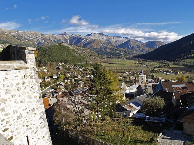
Verdaches (Verdaches)
- commune in Alpes-de-Haute-Provence, France
 Hiking in Verdaches
Verdaches is a lesser-known but beautiful destination for hiking enthusiasts, located in the southern French Alps. The region is characterized by stunning landscapes, diverse flora and fauna, and tranquil environments, making it a great spot for both casual and experienced hikers.
Key Highlights of Hiking in Verdaches:
-
Scenic Trails: The hiking trails in Verdaches offer a range of difficulty levels, from easy walks suitable for families to more challenging routes that cater to experienced trekkers. You can expect picturesque views of the mountains, valleys, and local wildlife.
-
Natural Beauty: The area is rich in natural beauty, with lush forests, alpine meadows, and dramatic cliffs. The variety of landscapes provides excellent opportunities for photography and nature observation.
-
Flora and Fauna: Depending on the season, hikers can encounter a wide range of plant species and wildlife. Spring brings colorful wildflowers, while you might spot animals like deer, chamois, and a variety of bird species throughout the year.
-
Cultural Experience: Hiking in Verdaches also offers a glimpse into the local culture and history. You may come across charming villages and historical sites along the trails, making for a culturally enriching experience.
-
Seasonal Considerations: The best time for hiking in this region is generally from spring to early autumn, when the weather is milder and the trails are usually accessible. Winter hiking may be possible in certain areas, but it requires proper winter hiking gear and experience.
-
Safety Precautions: As with any hiking trip, ensure you are well-prepared. Bring plenty of water, appropriate clothing, a map or GPS device, and inform someone about your hiking plans. It's also wise to check the weather forecast before heading out.
-
Local Regulations: Respect local regulations and guidelines regarding wildlife protection and trail conservation. Staying on marked trails helps preserve the natural environment for future visitors.
When planning your hiking adventure in Verdaches, consider the duration and difficulty of your chosen trail, and always prioritize safety to fully enjoy the beauty and tranquility the area has to offer. Happy hiking!
- Country:

- Postal Code: 04140
- Coordinates: 44° 15' 48" N, 6° 20' 32" E


- GPS tracks (wikiloc): [Link]
- Area: 22.92 sq km
- Population: 63
- Web site: http://www.verdaches.com
- Wikipedia en: wiki(en)
- Wikipedia: wiki(fr)
- Wikidata storage: Wikidata: Q521571
- Wikipedia Commons Category: [Link]
- Freebase ID: [/m/03m7xx9]
- Freebase ID: [/m/03m7xx9]
- GeoNames ID: Alt: [2969996]
- GeoNames ID: Alt: [2969996]
- SIREN number: [210402350]
- SIREN number: [210402350]
- INSEE municipality code: 04235
- INSEE municipality code: 04235
Shares border with regions:

Le Vernet
- commune in Alpes-de-Haute-Provence, France
Hiking in Le Vernet
Le Vernet, located in the Alpes-de-Haute-Provence region of France, offers a beautiful setting for hiking enthusiasts. This area is characterized by its stunning alpine landscapes, diverse flora and fauna, and a variety of trails that cater to different skill levels....
- Country:
- Postal Code: 04140
- Coordinates: 44° 16' 34" N, 6° 23' 27" E
- GPS tracks (wikiloc): [Link]
- Area: 23.05 sq km
- Population: 130

Auzet
- commune in Alpes-de-Haute-Provence, France
Hiking in Auzet
Auzet is a charming village in the Alpes-de-Haute-Provence region of southeastern France. It’s a great spot for hiking enthusiasts, offering stunning landscapes, serene nature, and a variety of trails suitable for different skill levels. Here are some highlights and tips for hiking in Auzet:...
- Country:
- Postal Code: 04140
- Coordinates: 44° 17' 39" N, 6° 19' 1" E
- GPS tracks (wikiloc): [Link]
- Area: 34.53 sq km
- Population: 98
- Web site: [Link]

Beaujeu
- commune in Alpes-de-Haute-Provence, France
Hiking in Beaujeu
Beaujeu, located in the Alpes-de-Haute-Provence region of southeastern France, is a lesser-known gem for hiking enthusiasts. The area is characterized by its stunning natural beauty, including rolling hills, rocky outcrops, and diverse landscapes that range from lush forests to arid terrain. Here are some highlights of hiking in Beaujeu:...
- Country:
- Postal Code: 04420
- Coordinates: 44° 12' 12" N, 6° 22' 18" E
- GPS tracks (wikiloc): [Link]
- Area: 45.68 sq km
- Population: 137
Seyne
- commune in Alpes-de-Haute-Provence, France
Hiking in Seyne
Seyne is a delightful town located in the Alpes-de-Haute-Provence region of France, and it offers a variety of hiking opportunities for outdoor enthusiasts. The surrounding landscape is characterized by stunning mountains, lush valleys, and picturesque views, making it an excellent destination for hikers of all skill levels....
- Country:
- Postal Code: 04140
- Coordinates: 44° 21' 2" N, 6° 21' 23" E
- GPS tracks (wikiloc): [Link]
- Area: 84.27 sq km
- Population: 1360
- Web site: [Link]

Barles
- commune in Alpes-de-Haute-Provence, France
Hiking in Barles
Barles is a small village located in the Alpes-de-Haute-Provence region of southern France, known for its beautiful natural scenery and opportunities for outdoor activities, including hiking. The region boasts diverse landscapes, including mountains, forests, and rivers, making it an excellent destination for hikers of all levels....
- Country:
- Postal Code: 04140
- Coordinates: 44° 15' 49" N, 6° 16' 5" E
- GPS tracks (wikiloc): [Link]
- Area: 59.05 sq km
- Population: 138

La Javie
- commune in Alpes-de-Haute-Provence, France
Hiking in La Javie
La Javie is a charming commune located in the Alpes-de-Haute-Provence department in southeastern France. This area is known for its stunning natural landscapes, which provide excellent opportunities for hiking and outdoor activities. Here are some key points about hiking in La Javie:...
- Country:
- Postal Code: 04000
- Coordinates: 44° 10' 28" N, 6° 21' 5" E
- GPS tracks (wikiloc): [Link]
- Area: 37.27 sq km
- Population: 391