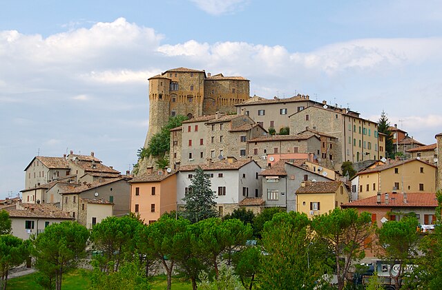
Verghereto (Verghereto)
.svg)
- Italian comune
 Hiking in Verghereto
Verghereto, located in the province of Forlì-Cesena in Emilia-Romagna, Italy, is an excellent destination for hiking enthusiasts. Nestled in the Apennine Mountains, the region is characterized by its stunning landscapes, lush forests, and a variety of trails suitable for different skill levels.
Hiking Highlights in Verghereto:
-
Scenic Trails: Verghereto offers a range of hiking trails that provide breathtaking views of the Apennines, with opportunities to explore both its natural beauty and its historical sites.
-
Parco Nazionale delle Foreste Casentinesi: This national park is nearby and features ancient woodlands, rich biodiversity, and numerous well-marked trails. You can enjoy exploring the forest, spotting wildlife, and visiting hermitages or monasteries along the way.
-
Trail Difficulty: Trails around Verghereto vary in difficulty. Beginners can find easier routes suitable for short hikes or family outings, while more advanced hikers can tackle steeper terrain and longer distances.
-
Sights Along the Way: While hiking, you can encounter charming villages, ancient churches, and local gastronomic specialties. Don’t miss trying local dishes and wines at the small trattorias that dot the area.
-
Wildlife: The region is home to various flora and fauna, including deer, wild boar, and numerous bird species. This rich ecosystem makes hiking here a rewarding experience for nature lovers.
-
Weather Considerations: The best time to hike in Verghereto is typically during spring and early autumn when temperatures are pleasant and the landscape is lush. Be mindful of changing weather conditions and plan accordingly.
Tips for Hiking in Verghereto:
- Preparation: Always bring adequate gear, including sturdy hiking boots, weather-appropriate clothing, and enough water and snacks.
- Maps and Navigation: It’s helpful to carry a map or download trail apps to stay informed about your route and ensure you don’t get lost.
- Sustainability: Practice Leave No Trace principles to help preserve the natural beauty of the environment for future hikers.
Verghereto offers a wonderful opportunity to immerse yourself in nature and experience the tranquility of the Italian outdoors. Happy hiking!
- Country:

- Postal Code: 47028
- Local Dialing Code: 0543
- Licence Plate Code: FC
- Coordinates: 43° 48' 0" N, 11° 58' 0" E


- GPS tracks (wikiloc): [Link]
- AboveSeaLevel: 812 м m
- Area: 117.9 sq km
- Population: 1860
- Web site: http://www.comune.verghereto.fc.it
- Wikipedia en: wiki(en)
- Wikipedia: wiki(it)
- Wikidata storage: Wikidata: Q99960
- Wikipedia Commons Category: [Link]
- Freebase ID: [/m/0gkmd4]
- GeoNames ID: Alt: [6540441]
- VIAF ID: Alt: [243227582]
- OSM relation ID: [42608]
- GND ID: Alt: [7624878-1]
- ISTAT ID: 040050
- Italian cadastre code: L764
Shares border with regions:


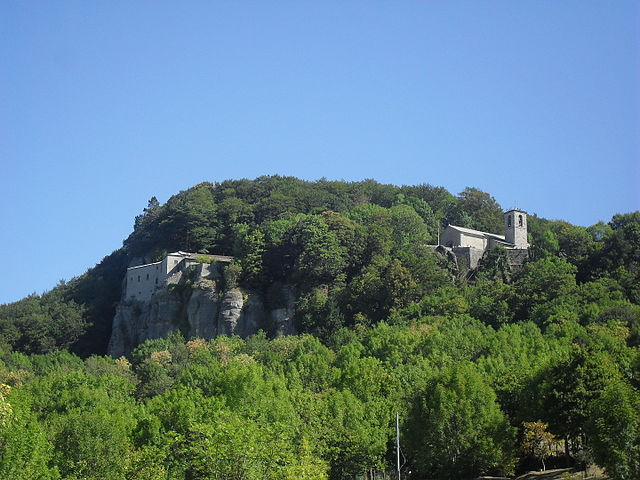
Casteldelci
- Italian comune
Hiking in Casteldelci
Casteldelci is a charming village located in the Emilia-Romagna region of Italy, nestled in the beautiful hills of the Appennine Mountains. Known for its stunning landscapes and rich natural diversity, the area offers a variety of hiking opportunities for all levels of experience. Here are some key aspects to consider when hiking in Casteldelci:...
- Country:
- Postal Code: 47861
- Local Dialing Code: 0541
- Licence Plate Code: RN
- Coordinates: 43° 47' 29" N, 12° 9' 19" E
- GPS tracks (wikiloc): [Link]
- AboveSeaLevel: 632 м m
- Area: 49.68 sq km
- Population: 389
- Web site: [Link]

Sant'Agata Feltria
- Italian comune
Hiking in Sant'Agata Feltria
Sant'Agata Feltria is a charming town located in the Emilia-Romagna region of Italy, surrounded by beautiful natural landscapes, making it an excellent destination for hiking enthusiasts. Here’s what you should know about hiking in this area:...
- Country:
- Postal Code: 47866
- Local Dialing Code: 0547
- Licence Plate Code: RN
- Coordinates: 43° 51' 50" N, 12° 12' 31" E
- GPS tracks (wikiloc): [Link]
- AboveSeaLevel: 606 м m
- Area: 79.74 sq km
- Population: 2121
- Web site: [Link]


Badia Tedalda
- Italian comune
Hiking in Badia Tedalda
Badia Tedalda is a beautiful destination located in the province of Arezzo in Tuscany, Italy. Nestled in the Valtiberina valley, this area is known for its stunning landscapes, rich history, and natural beauty, making it an excellent spot for hiking enthusiasts....
- Country:
- Postal Code: 53032
- Local Dialing Code: 0575
- Licence Plate Code: AR
- Coordinates: 43° 42' 29" N, 12° 11' 14" E
- GPS tracks (wikiloc): [Link]
- AboveSeaLevel: 700 м m
- Area: 119.03 sq km
- Population: 1075
- Web site: [Link]

Chiusi della Verna
- Italian comune
Hiking in Chiusi della Verna
Chiusi della Verna, nestled in the Casentino Forests of Tuscany, Italy, is a fantastic destination for hikers. It offers a blend of natural beauty, historical significance, and a variety of trails catering to different skill levels. Here are some key points to consider when hiking in Chiusi della Verna:...
- Country:
- Postal Code: 52010
- Local Dialing Code: 0575
- Licence Plate Code: AR
- Coordinates: 43° 41' 54" N, 11° 56' 10" E
- GPS tracks (wikiloc): [Link]
- AboveSeaLevel: 960 м m
- Area: 102.33 sq km
- Population: 2000
- Web site: [Link]

Pieve Santo Stefano
- Italian comune
Hiking in Pieve Santo Stefano
Pieve Santo Stefano, located in Tuscany, Italy, is an enchanting destination for hikers. Nestled in the Casentino region, it offers a diverse range of trails that cater to various skill levels, all while showcasing stunning landscapes, rich history, and cultural heritage....
- Country:
- Postal Code: 52036
- Local Dialing Code: 0575
- Licence Plate Code: AR
- Coordinates: 43° 40' 21" N, 12° 2' 32" E
- GPS tracks (wikiloc): [Link]
- AboveSeaLevel: 431 м m
- Area: 156.1 sq km
- Population: 3117
- Web site: [Link]

Bagno di Romagna
- Italian comune
Hiking in Bagno di Romagna
Bagno di Romagna, located in the Emilia-Romagna region of Italy, is a beautiful destination for hiking enthusiasts. Nestled in the Casentino Forests, Monte Falterona, and Campigna National Park, this area offers a variety of trails that cater to different skill levels and interests, all within stunning natural surroundings....
- Country:
- Postal Code: 47021
- Local Dialing Code: 0543
- Licence Plate Code: FC
- Coordinates: 43° 50' 0" N, 11° 58' 0" E
- GPS tracks (wikiloc): [Link]
- AboveSeaLevel: 491 м m
- Area: 233.52 sq km
- Population: 5874
- Web site: [Link]


Sarsina
- Italian comune
Hiking in Sarsina
Sarsina, located in the Emilia-Romagna region of Italy, is a charming town that offers various hiking opportunities amidst beautiful landscapes and rich historical and cultural heritage. The surrounding area includes the Appenine Mountains, which provide a variety of trails suitable for different skill levels....
- Country:
- Postal Code: 47027
- Local Dialing Code: 0547
- Licence Plate Code: FC
- Coordinates: 43° 55' 0" N, 12° 9' 0" E
- GPS tracks (wikiloc): [Link]
- AboveSeaLevel: 243 м m
- Area: 100 sq km
- Population: 3662
- Web site: [Link]