Vers (Vers)

- former commune in Lot, France
- Country:

- Postal Code: 46090
- Coordinates: 44° 29' 9" N, 1° 33' 14" E


- GPS tracks (wikiloc): [Link]
- Area: 17.94 sq km
- Population: 416
- Web site: http://www.commune-de-vers.fr/
- Wikipedia en: wiki(en)
- Wikipedia: wiki(fr)
- Wikidata storage: Wikidata: Q940110
- Wikipedia Commons Category: [Link]
- Freebase ID: [/m/03nwpky]
- GeoNames ID: Alt: [6454178]
- BnF ID: [15261072j]
- INSEE municipality code: 46331
Shares border with regions:


Arcambal
- commune in Lot, France
- Country:
- Postal Code: 46090
- Coordinates: 44° 27' 23" N, 1° 30' 51" E
- GPS tracks (wikiloc): [Link]
- Area: 23.11 sq km
- Population: 999

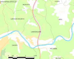
Lamagdelaine
- commune in Lot, France
- Country:
- Postal Code: 46090
- Coordinates: 44° 28' 3" N, 1° 29' 22" E
- GPS tracks (wikiloc): [Link]
- Area: 10.58 sq km
- Population: 715
Valroufié
- former commune in Lot, France
- Country:
- Postal Code: 46090
- Coordinates: 44° 31' 8" N, 1° 29' 16" E
- GPS tracks (wikiloc): [Link]
- Area: 13.48 sq km
- Population: 440


Saint-Géry
- former commune in Lot, France
- Country:
- Postal Code: 46330
- Coordinates: 44° 28' 43" N, 1° 34' 52" E
- GPS tracks (wikiloc): [Link]
- Area: 13.58 sq km
- Population: 443


Cabrerets
- commune in Lot, France
- Country:
- Postal Code: 46330
- Coordinates: 44° 30' 22" N, 1° 39' 17" E
- GPS tracks (wikiloc): [Link]
- Area: 43.38 sq km
- Population: 230
Cours
- former commune in Lot, France
- Country:
- Postal Code: 46090
- Coordinates: 44° 31' 7" N, 1° 32' 27" E
- GPS tracks (wikiloc): [Link]
- Area: 17.05 sq km
- Population: 283