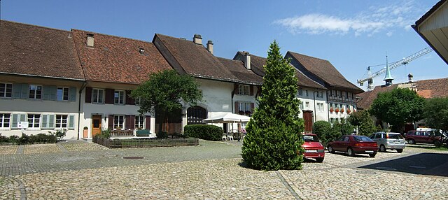
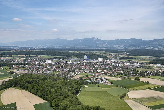
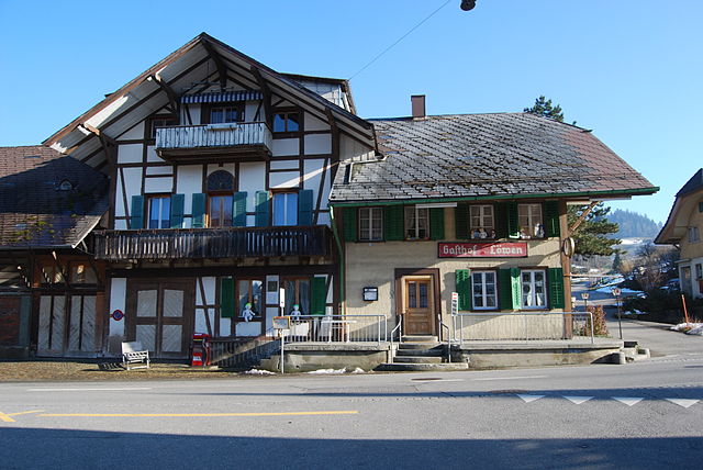
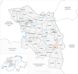
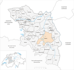
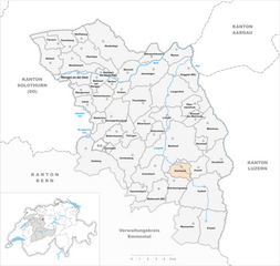
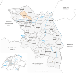
Oberaargau administrative district (Verwaltungskreis Oberaargau)
- administrative district of the canton of Bern, Switzerland (Verwaltungskreis)
 Hiking in Oberaargau administrative district
Verwaltungskreis Oberaargau, located in the canton of Aargau in Switzerland, is known for its beautiful landscapes and diverse hiking trails. The region offers a mix of rolling hills, lush forests, and the charm of small Swiss towns, making it a great destination for hikers of all skill levels.
Hiking Highlights in Oberaargau:
-
Trail Variety: There are numerous marked hiking trails in the area, ranging from easy family-friendly paths to more challenging routes for experienced hikers. This variety allows everyone to enjoy the natural beauty of the region.
-
Scenic Landscapes: The trails often provide stunning views of the surrounding hills, valleys, and, on clear days, the distant Alps. You'll also have the opportunity to explore picturesque villages and historical sites along the way.
-
Nature and Wildlife: Oberaargau is home to diverse flora and fauna. Keep an eye out for local wildlife during your hikes, and enjoy the seasonal beauty of wildflowers in spring and vibrant foliage in autumn.
-
Regional Highlights: Key points of interest include the Aare River, which flows through the area, and various castles and historical landmarks. The town of Langenthal is a great starting point for many hikes and offers additional amenities.
-
Well-Marked Paths: The hiking trails are generally well-marked with signposts displaying distances and estimated hiking times, making it easy to navigate.
-
Local Culture: Besides hiking, explore the local culture by visiting farms, trying traditional Swiss cuisine in nearby towns, and participating in community events.
Tips for Hiking in Oberaargau:
-
Weather Check: Swiss weather can change rapidly, so always check the forecast before heading out and be prepared for varying conditions.
-
Footwear: Wear appropriate hiking shoes to ensure comfort and support during your hikes, especially on uneven terrain.
-
Hydration and Snacks: Carry enough water and snacks, as some trails may be remote with limited access to facilities.
-
Respect Nature: Follow the Leave No Trace principles to preserve the natural beauty of the trails for future hikers.
-
Local Guidance: If you’re unfamiliar with the area or looking for specific trails, consider joining a guided hike or visiting local tourist information centers for maps and recommendations.
Hiking in Verwaltungskreis Oberaargau can be a rewarding experience, combining outdoor activity with the beauty of Swiss nature and culture. Enjoy your adventure!
- Country:

- Capital: Wangen an der Aare
- Licence Plate Code: BE
- Coordinates: 47° 11' 12" N, 7° 46' 23" E


- GPS tracks (wikiloc): [Link]
- Wikidata storage: Wikidata: Q678827
- Wikipedia Commons Category: [Link]
- archINFORM location ID: [42771]
Includes regions:


Gondiswil
- municipality in Switzerland
Hiking in Gondiswil
Gondiswil, a charming village located in the Canton of Lucerne in Switzerland, offers a variety of hiking opportunities that cater to different skill levels. Nestled in the picturesque Swiss landscape, the area is characterized by stunning views, rolling hills, and lush meadows, making it a great destination for outdoor enthusiasts....
- Country:
- Postal Code: 4955
- Local Dialing Code: 062
- Licence Plate Code: BE
- Coordinates: 47° 8' 36" N, 7° 52' 6" E
- GPS tracks (wikiloc): [Link]
- AboveSeaLevel: 648 м m
- Area: 9.4 sq km
- Population: 731
- Web site: [Link]


Eriswil
- municipality in Switzerland
Hiking in Eriswil
Eriswil, a picturesque village located in the Emmental region of Switzerland, offers a variety of stunning hiking opportunities for both novices and experienced hikers alike. Here’s an overview of what you can expect when hiking in the area:...
- Country:
- Postal Code: 4952
- Local Dialing Code: 062
- Licence Plate Code: BE
- Coordinates: 47° 4' 18" N, 7° 51' 28" E
- GPS tracks (wikiloc): [Link]
- AboveSeaLevel: 785 м m
- Area: 11.3 sq km
- Population: 1399
- Web site: [Link]


Wyssachen
- municipality in Switzerland
Hiking in Wyssachen
Wyssachen is a small municipality located in the canton of Bern, Switzerland. While it may not be as well-known as some of the larger hiking destinations in the region, it offers beautiful landscapes and rural scenery ideal for hiking enthusiasts....
- Country:
- Postal Code: 4954
- Local Dialing Code: 062
- Licence Plate Code: BE
- Coordinates: 47° 4' 26" N, 7° 49' 17" E
- GPS tracks (wikiloc): [Link]
- AboveSeaLevel: 793 м m
- Area: 11.69 sq km
- Population: 1161
- Web site: [Link]


Wolfisberg
- municipality in Switzerland
Hiking in Wolfisberg
Wolfisberg is a scenic area that offers various hiking trails suitable for different skill levels. Located in the Swiss region, it can be a great spot for both beginner and experienced hikers....
- Country:
- Postal Code: 4704
- Local Dialing Code: 032
- Licence Plate Code: BE
- Coordinates: 47° 16' 38" N, 7° 39' 31" E
- GPS tracks (wikiloc): [Link]
- AboveSeaLevel: 799 м m
- Area: 2.44 sq km
- Population: 179
- Web site: [Link]


Bannwil
- municipality in Switzerland
Hiking in Bannwil
Bannwil is a charming municipality located in the canton of Bern, Switzerland. It is an excellent location for hikers due to its scenic landscapes and proximity to the Swiss Alps. Here are some key points to consider when hiking in and around Bannwil:...
- Country:
- Postal Code: 4913
- Local Dialing Code: 062
- Licence Plate Code: BE
- Coordinates: 47° 14' 19" N, 7° 43' 50" E
- GPS tracks (wikiloc): [Link]
- AboveSeaLevel: 454 м m
- Area: 4.8 sq km
- Population: 681
- Web site: [Link]


Lotzwil
- municipality in Switzerland
Hiking in Lotzwil
Lotzwil is a picturesque area located in the Canton of Bern, Switzerland. It's surrounded by beautiful landscapes, making it a delightful destination for hiking enthusiasts. Here are some insights to help you plan your hiking adventure in Lotzwil:...
- Country:
- Postal Code: 4932
- Local Dialing Code: 062
- Licence Plate Code: BE
- Coordinates: 47° 11' 25" N, 7° 47' 31" E
- GPS tracks (wikiloc): [Link]
- AboveSeaLevel: 502 м m
- Area: 6.02 sq km
- Population: 2555
- Web site: [Link]


Melchnau
- municipality in Switzerland
Hiking in Melchnau
Melchnau is a picturesque village located in the canton of Lucerne, Switzerland. It offers a range of hiking opportunities that cater to different skill levels, making it a great destination for both beginners and seasoned hikers. Here are some highlights and tips for hiking in the Melchnau area:...
- Country:
- Postal Code: 4917
- Local Dialing Code: 062
- Licence Plate Code: BE
- Coordinates: 47° 10' 38" N, 7° 51' 22" E
- GPS tracks (wikiloc): [Link]
- AboveSeaLevel: 546 м m
- Area: 10.4 sq km
- Population: 1536
- Web site: [Link]

Wiedlisbach
- municipality in Switzerland
Hiking in Wiedlisbach
Wiedlisbach is a charming municipality located in the Bern-Mittelland district of Switzerland, and although it may not be as widely known as some major hiking destinations in the Swiss Alps, it offers beautiful landscapes and a range of hiking opportunities....
- Country:
- Postal Code: 4537
- Local Dialing Code: 032
- Licence Plate Code: BE
- Coordinates: 47° 15' 7" N, 7° 38' 48" E
- GPS tracks (wikiloc): [Link]
- AboveSeaLevel: 437 м m
- Area: 7.5 sq km
- Population: 2317
- Web site: [Link]


Obersteckholz
- municipality in Switzerland
Hiking in Obersteckholz
Obersteckholz, located in the picturesque region of Switzerland, offers a variety of hiking opportunities that allow you to experience stunning landscapes, charming villages, and a rich natural environment. Here are some key points to consider when planning a hiking trip in Obersteckholz:...
- Country:
- Postal Code: 4924
- Local Dialing Code: 062
- Licence Plate Code: BE
- Coordinates: 47° 12' 7" N, 7° 49' 32" E
- GPS tracks (wikiloc): [Link]
- AboveSeaLevel: 554 м m
- Area: 3.9 sq km
- Population: 412
- Web site: [Link]


Rohrbachgraben
- municipality in the canton of Bern, Switzerland
Hiking in Rohrbachgraben
Rohrbachgraben is a picturesque hiking area located in the heart of nature, often appreciated for its tranquil landscapes and scenic views. Situated in Austria or Germany (depending on the specific region you are referring to), this area usually features lush greenery, scenic trails, and sometimes small streams or waterfalls that enhance the hiking experience....
- Country:
- Postal Code: 4938
- Local Dialing Code: 062
- Licence Plate Code: BE
- Coordinates: 47° 6' 47" N, 7° 48' 10" E
- GPS tracks (wikiloc): [Link]
- AboveSeaLevel: 699 м m
- Area: 6.5 sq km
- Population: 397
- Web site: [Link]


Attiswil
- municipality in Switzerland
Hiking in Attiswil
Attiswil, a charming village in the canton of Solothurn, Switzerland, offers a beautiful backdrop for hiking enthusiasts. Nestled in the Swiss countryside, it provides access to various trails that feature stunning landscapes, rolling hills, and scenic views of the surrounding nature....
- Country:
- Postal Code: 4536
- Local Dialing Code: 032
- Licence Plate Code: BE
- Coordinates: 47° 14' 50" N, 7° 36' 49" E
- GPS tracks (wikiloc): [Link]
- AboveSeaLevel: 572 м m
- Area: 7.7 sq km
- Population: 1451
- Web site: [Link]


Walliswil bei Wangen
- municipality in Switzerland
Hiking in Walliswil bei Wangen
Walliswil bei Wangen is a charming village located in the Canton of Bern, Switzerland. The area offers beautiful hiking opportunities that allow you to appreciate the picturesque landscapes, rolling hills, and serene countryside....
- Country:
- Postal Code: 3377
- Local Dialing Code: 032
- Licence Plate Code: BE
- Coordinates: 47° 13' 52" N, 7° 41' 6" E
- GPS tracks (wikiloc): [Link]
- AboveSeaLevel: 456 м m
- Area: 3.05 sq km
- Population: 601
- Web site: [Link]


Busswil bei Melchnau
- municipality in Switzerland
Hiking in Busswil bei Melchnau
Busswil bei Melchnau is a charming village located in the canton of Bern, Switzerland, surrounded by scenic landscapes that are ideal for hiking enthusiasts. Here's what you can expect when hiking in this area:...
- Country:
- Postal Code: 4917
- Local Dialing Code: 062
- Licence Plate Code: BE
- Coordinates: 47° 11' 13" N, 7° 50' 0" E
- GPS tracks (wikiloc): [Link]
- AboveSeaLevel: 559 м m
- Area: 2.8 sq km
- Population: 188
- Web site: [Link]

Herzogenbuchsee
- municipality in Switzerland
Hiking in Herzogenbuchsee
Herzogenbuchsee is a charming municipality located in the canton of Bern, Switzerland. Surrounded by picturesque landscapes, it provides a wonderful setting for hiking enthusiasts. Here are some key points to consider when planning a hike in and around Herzogenbuchsee:...
- Country:
- Postal Code: 3360
- Local Dialing Code: 062
- Licence Plate Code: BE
- Coordinates: 47° 11' 18" N, 7° 42' 22" E
- GPS tracks (wikiloc): [Link]
- AboveSeaLevel: 474 м m
- Area: 9.8 sq km
- Population: 7140
- Web site: [Link]


Wangen an der Aare
- municipality in the canton of Bern, Switzerland
Hiking in Wangen an der Aare
Wangen an der Aare is a picturesque village located in the Canton of Bern, Switzerland, known for its beautiful landscapes and access to various hiking trails. The village is situated along the Aare River, surrounded by rolling hills and forests that provide a tranquil environment for outdoor activities....
- Country:
- Postal Code: 3380
- Local Dialing Code: 032
- Licence Plate Code: BE
- Coordinates: 47° 13' 52" N, 7° 39' 1" E
- GPS tracks (wikiloc): [Link]
- AboveSeaLevel: 421 м m
- Area: 5.2 sq km
- Population: 2301
- Web site: [Link]

Walterswil
- municipality in the canton of Bern, Switzerland
Hiking in Walterswil
Walterswil, located in the canton of Bern, Switzerland, offers a picturesque setting for hiking enthusiasts. The area is characterized by its rolling hills, lush forests, and panoramic views of the surrounding landscape, including the beautiful Swiss countryside and the Bernese Alps in the distance....
- Country:
- Postal Code: 4942
- Local Dialing Code: 062
- Licence Plate Code: BE
- Coordinates: 47° 6' 15" N, 7° 46' 12" E
- GPS tracks (wikiloc): [Link]
- AboveSeaLevel: 782 м m
- Area: 7.9 sq km
- Population: 554
- Web site: [Link]
Wangenried
- municipality in Switzerland
Hiking in Wangenried
Wangenried is a small municipality located in the Swiss canton of Aargau, typically characterized by picturesque rural landscapes, rolling hills, and scenic views. While not one of the most prominent hiking destinations in Switzerland, it offers some lovely trails and opportunities for outdoor activities....
- Country:
- Postal Code: 3374
- Local Dialing Code: 032
- Licence Plate Code: BE
- Coordinates: 47° 13' 4" N, 7° 39' 33" E
- GPS tracks (wikiloc): [Link]
- AboveSeaLevel: 477 м m
- Area: 2.91 sq km
- Population: 431
- Web site: [Link]
Bettenhausen
- municipality in the canton of Bern, Switzerland
Hiking in Bettenhausen
Bettenhausen is not one of the widely recognized hiking destinations in Switzerland, but if you're referring to the general region of central or eastern Switzerland, there are many beautiful areas for hiking. Here's an overview of what you might expect for hiking in this region:...
- Country:
- Postal Code: 3366
- Local Dialing Code: 062
- Licence Plate Code: BE
- Coordinates: 47° 10' 21" N, 7° 42' 56" E
- GPS tracks (wikiloc): [Link]
- AboveSeaLevel: 480 м m
- Area: 3.95 sq km
- Population: 637
- Web site: [Link]

Auswil
- municipality in Switzerland
Hiking in Auswil
Auswil is a charming village located in the canton of Aargau in Switzerland. It's surrounded by picturesque landscapes that offer a variety of hiking opportunities for outdoor enthusiasts. Here are some highlights and tips for hiking in and around Auswil:...
- Country:
- Postal Code: 4944
- Local Dialing Code: 062
- Licence Plate Code: BE
- Coordinates: 47° 8' 15" N, 7° 50' 0" E
- GPS tracks (wikiloc): [Link]
- AboveSeaLevel: 650 м m
- Area: 4.60 sq km
- Population: 447
- Web site: [Link]


Hermiswil
- former municipality of Switzerland
Hiking in Hermiswil
Hermiswil is a charming village located in the canton of Bern, Switzerland, that offers various hiking opportunities in a picturesque alpine setting. While the specific trails can vary based on current conditions and accessibility, here are some general points to consider if you’re planning to hike in and around Hermiswil:...
- Country:
- Postal Code: 3475
- Local Dialing Code: 062
- Licence Plate Code: BE
- Coordinates: 47° 9' 10" N, 7° 41' 47" E
- GPS tracks (wikiloc): [Link]
- AboveSeaLevel: 494 м m
- Area: 1.1 sq km


Bleienbach
- municipality in Switzerland
Hiking in Bleienbach
Bleienbach, located in Switzerland, offers a wonderful opportunity for hiking enthusiasts to explore the beautiful Swiss landscapes. Here are some highlights to consider when hiking in this region:...
- Country:
- Postal Code: 3368
- Local Dialing Code: 062
- Licence Plate Code: BE
- Coordinates: 47° 11' 10" N, 7° 45' 25" E
- GPS tracks (wikiloc): [Link]
- AboveSeaLevel: 505 м m
- Area: 5.7 sq km
- Population: 697
- Web site: [Link]


Schwarzhäusern
- municipality in Switzerland
Hiking in Schwarzhäusern
Schwarzhäusern is a picturesque area located in southern Germany, known for its beautiful landscapes and outdoor recreational opportunities. The region is particularly famous for its dense forests, rolling hills, and varied terrain, making it an attractive destination for hikers of all skill levels....
- Country:
- Postal Code: 4911
- Local Dialing Code: 062
- Licence Plate Code: BE
- Coordinates: 47° 15' 14" N, 7° 46' 0" E
- GPS tracks (wikiloc): [Link]
- AboveSeaLevel: 427 м m
- Area: 3.7 sq km
- Population: 517
- Web site: [Link]


Rütschelen
- municipality in Switzerland
Hiking in Rütschelen
Rütschelen is a small municipality in the canton of Aargau, Switzerland. While it may not be as widely recognized as some larger hiking destinations, it offers beautiful landscapes and a peaceful hiking experience, perfect for those looking to explore the natural beauty of the area....
- Country:
- Postal Code: 4933
- Local Dialing Code: 062
- Licence Plate Code: BE
- Coordinates: 47° 10' 25" N, 7° 46' 30" E
- GPS tracks (wikiloc): [Link]
- AboveSeaLevel: 575 м m
- Area: 4.0 sq km
- Population: 564
- Web site: [Link]

Madiswil
- municipality in Switzerland
Hiking in Madiswil
Madiswil is a charming municipality in the canton of Bern, Switzerland, surrounded by stunning landscapes that make it a great destination for hiking enthusiasts. Nestled in the beautiful foothills of the Alps, Madiswil offers various hiking trails that cater to different skill levels, from leisurely walks to more challenging hikes....
- Country:
- Postal Code: 4934
- Local Dialing Code: 062
- Licence Plate Code: BE
- Coordinates: 47° 9' 46" N, 7° 48' 38" E
- GPS tracks (wikiloc): [Link]
- AboveSeaLevel: 593 м m
- Area: 23.19 sq km
- Population: 3279
- Web site: [Link]


Graben
- municipality in the canton of Bern, Switzerland
Hiking in Graben
Graben, Switzerland, isn't one of the most commonly recognized hiking destinations compared to the well-known regions like the Jungfrau or Zermatt, but it can serve as a starting point for exploring the beautiful Swiss landscape. If you're looking for hiking in this area, you may be referring to nearby regions or attractions....
- Country:
- Postal Code: 3376
- Local Dialing Code: 062
- Licence Plate Code: BE
- Coordinates: 47° 13' 3" N, 7° 43' 16" E
- GPS tracks (wikiloc): [Link]
- AboveSeaLevel: 455 м m
- Area: 3.2 sq km
- Population: 332
- Web site: [Link]


Inkwil
- municipality in Switzerland
Hiking in Inkwil
Inkwil is a small village located in the canton of Bern in Switzerland, known for its picturesque landscapes and proximity to hiking trails. While Inkwil itself might not be a major hiking destination, the surrounding areas offer a variety of trails suitable for all levels of hikers....
- Country:
- Postal Code: 3375
- Local Dialing Code: 062
- Licence Plate Code: BE
- Coordinates: 47° 12' 10" N, 7° 40' 12" E
- GPS tracks (wikiloc): [Link]
- AboveSeaLevel: 471 м m
- Area: 3.4 sq km
- Population: 607
- Web site: [Link]


Heimenhausen
- municipality in Switzerland
Hiking in Heimenhausen
Heimenhausen, a charming area located in Switzerland, is surrounded by beautiful landscapes that make for delightful hiking experiences. Nestled in the foothills of the Alps, hiking in and around Heimenhausen offers stunning views, diverse terrain, and opportunities to explore local flora and fauna....
- Country:
- Postal Code: 3373
- Local Dialing Code: 062
- Licence Plate Code: BE
- Coordinates: 47° 12' 35" N, 7° 41' 30" E
- GPS tracks (wikiloc): [Link]
- AboveSeaLevel: 472 м m
- Area: 5.9 sq km
- Population: 1115
- Web site: [Link]
Oeschenbach
- municipality in Switzerland
Hiking in Oeschenbach
Oeschenbach, a scenic area located in Switzerland, offers a variety of beautiful hiking opportunities for outdoor enthusiasts. Here are some key points you might find helpful:...
- Country:
- Postal Code: 4943
- Local Dialing Code: 062
- Licence Plate Code: BE
- Coordinates: 47° 6' 9" N, 7° 44' 49" E
- GPS tracks (wikiloc): [Link]
- AboveSeaLevel: 718 м m
- Area: 3.9 sq km
- Population: 240
- Web site: [Link]

Niederönz
- municipality in Switzerland
Hiking in Niederönz
Niederönz, located in the canton of Bern, Switzerland, is a scenic area that offers beautiful hiking opportunities. The region is characterized by its picturesque landscapes, featuring rolling hills, lush forests, and stunning views of the surrounding mountains....
- Country:
- Postal Code: 3362
- Local Dialing Code: 062
- Licence Plate Code: BE
- Coordinates: 47° 11' 1" N, 7° 41' 22" E
- GPS tracks (wikiloc): [Link]
- AboveSeaLevel: 465 м m
- Area: 2.8 sq km
- Population: 1675
- Web site: [Link]


Thunstetten
- municipality in the canton of Bern, Switzerland
Hiking in Thunstetten
Thunstetten is a charming village located in the Canton of Bern, Switzerland. The surrounding region offers a variety of hiking opportunities, with beautiful landscapes typical of the Swiss countryside, including rolling hills, pastures, and forests. Here are some details to consider when hiking in Thunstetten:...
- Country:
- Postal Code: 4922
- Local Dialing Code: 062
- Licence Plate Code: BE
- Coordinates: 47° 12' 20" N, 7° 44' 47" E
- GPS tracks (wikiloc): [Link]
- AboveSeaLevel: 475 м m
- Area: 9.7 sq km
- Population: 3320
- Web site: [Link]

Berken
- municipality in Switzerland
Hiking in Berken
It seems like you might be referring to a specific location, but "Berken" might be a typo or the name of a lesser-known area. Could you clarify whether you're talking about a place in a specific country or region?...
- Country:
- Postal Code: 3376
- Local Dialing Code: 062
- Licence Plate Code: BE
- Coordinates: 47° 13' 32" N, 7° 42' 20" E
- GPS tracks (wikiloc): [Link]
- AboveSeaLevel: 439 м m
- Area: 1.39 sq km
- Population: 43
- Web site: [Link]


Reisiswil
- municipality in Switzerland
Hiking in Reisiswil
Reisiswil, a picturesque village in the canton of Bern, Switzerland, offers a range of hiking opportunities perfect for both casual walkers and avid trekkers. Nestled in the rolling green hills and near the scenic Emmental valley, it provides a stunning backdrop for outdoor activities....
- Country:
- Postal Code: 4919
- Local Dialing Code: 062
- Licence Plate Code: BE
- Coordinates: 47° 9' 41" N, 7° 50' 33" E
- GPS tracks (wikiloc): [Link]
- AboveSeaLevel: 647 м m
- Area: 2.0 sq km
- Population: 177
- Web site: [Link]

Walliswil bei Niederbipp
- municipality in Switzerland
Hiking in Walliswil bei Niederbipp
Walliswil bei Niederbipp, located in the Canton of Bern in Switzerland, offers a picturesque setting for hiking enthusiasts. This region is characterized by its rolling hills, lush meadows, and scenic views of the surrounding mountains, making it a delightful destination for outdoor activities. Here are some key points about hiking in Walliswil bei Niederbipp:...
- Country:
- Postal Code: 3380
- Local Dialing Code: 032
- Licence Plate Code: BE
- Coordinates: 47° 15' 13" N, 7° 41' 23" E
- GPS tracks (wikiloc): [Link]
- AboveSeaLevel: 431 м m
- Area: 1.48 sq km
- Population: 221
- Web site: [Link]


Ochlenberg
- municipality in Switzerland
Hiking in Ochlenberg
Ochlenberg, often characterized by its scenic landscapes and diverse ecosystems, offers a variety of hiking trails for outdoor enthusiasts of all skill levels. While specific details about the trails can vary based on the region, here are some general tips and highlights for hiking in the area:...
- Country:
- Postal Code: 3367
- Local Dialing Code: 062
- Licence Plate Code: BE
- Coordinates: 47° 8' 45" N, 7° 43' 54" E
- GPS tracks (wikiloc): [Link]
- AboveSeaLevel: 584 м m
- Area: 12.1 sq km
- Population: 563
- Web site: [Link]


Roggwil
- municipality in the canton of Bern, Switzerland
Hiking in Roggwil
Roggwil, located in the canton of Bern, Switzerland, offers a serene and picturesque setting for hiking enthusiasts. The region is characterized by its rolling hills, lush farmland, and views of the Swiss Alps in the distance. Here are some key points about hiking in Roggwil:...
- Country:
- Postal Code: 4914
- Local Dialing Code: 062
- Licence Plate Code: BE
- Coordinates: 47° 14' 30" N, 7° 49' 25" E
- GPS tracks (wikiloc): [Link]
- AboveSeaLevel: 421 м m
- Area: 7.73 sq km
- Population: 4051
- Web site: [Link]


Farnern
- municipality in Switzerland
Hiking in Farnern
Farnern, located in the picturesque region of Switzerland, offers a variety of hiking opportunities that cater to different skill levels and preferences. While it's a small area, hiking here provides stunning views of the surrounding landscapes, including mountains, forests, and lakes....
- Country:
- Postal Code: 4539
- Local Dialing Code: 032
- Licence Plate Code: BE
- Coordinates: 47° 16' 14" N, 7° 36' 37" E
- GPS tracks (wikiloc): [Link]
- AboveSeaLevel: 925 м m
- Area: 3.7 sq km
- Population: 205
- Web site: [Link]


Niederbipp
- municipality in Switzerland
Hiking in Niederbipp
Niederbipp is a charming village located in the canton of Bern, Switzerland, and it is surrounded by beautiful landscapes that make it a great area for hiking. Here are some highlights and tips for hiking in and around Niederbipp:...
- Country:
- Postal Code: 4704
- Local Dialing Code: 032
- Licence Plate Code: BE
- Coordinates: 47° 15' 58" N, 7° 42' 14" E
- GPS tracks (wikiloc): [Link]
- AboveSeaLevel: 455 м m
- Area: 17.5 sq km
- Population: 4717
- Web site: [Link]


Aarwangen
- municipality in the canton of Bern, Switzerland
Hiking in Aarwangen
Aarwangen, located in the canton of Aargau in Switzerland, offers a variety of hiking opportunities amidst beautiful landscapes. Here are some details you might find helpful for hiking in the area:...
- Country:
- Postal Code: 4912
- Local Dialing Code: 032
- Licence Plate Code: BE
- Coordinates: 47° 14' 29" N, 7° 46' 15" E
- GPS tracks (wikiloc): [Link]
- AboveSeaLevel: 437 м m
- Area: 9.90 sq km
- Population: 4514
- Web site: [Link]


Huttwil
- municipality in Switzerland
Hiking in Huttwil
Huttwil, located in the Emmental region of Switzerland, offers a picturesque setting for hiking enthusiasts. With its rolling hills, lush landscapes, and charming rural vistas, it’s an excellent destination for all levels of hikers. Here are some highlights about hiking in and around Huttwil:...
- Country:
- Postal Code: 4950
- Local Dialing Code: 062
- Licence Plate Code: BE
- Coordinates: 47° 6' 59" N, 7° 51' 0" E
- GPS tracks (wikiloc): [Link]
- AboveSeaLevel: 710 м m
- Area: 17.3 sq km
- Population: 4836
- Web site: [Link]


Langenthal
- municipality in Switzerland
Hiking in Langenthal
Langenthal, situated in the Canton of Bern, Switzerland, offers a variety of hiking opportunities amid beautiful landscapes. The region is characterized by rolling hills, scenic farmland, and views of the Bernese Alps in the distance, making it a great destination for both novice and experienced hikers....
- Country:
- Postal Code: 4900
- Local Dialing Code: 062
- Licence Plate Code: BE
- Coordinates: 47° 12' 55" N, 7° 47' 20" E
- GPS tracks (wikiloc): [Link]
- AboveSeaLevel: 481 м m
- Area: 17.3 sq km
- Population: 15639
- Web site: [Link]


Wynau
- municipality in Switzerland
Hiking in Wynau
Wynau, located in the canton of Aargau in Switzerland, is a great place for hiking enthusiasts. The region is characterized by its picturesque landscapes, lush greenery, and a mix of flat terrains and gentle hills, providing a variety of trails for different skill levels....
- Country:
- Postal Code: 4923
- Local Dialing Code: 062
- Licence Plate Code: BE
- Coordinates: 47° 15' 22" N, 7° 48' 19" E
- GPS tracks (wikiloc): [Link]
- AboveSeaLevel: 481 м m
- Area: 5.1 sq km
- Population: 1630
- Web site: [Link]
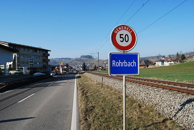
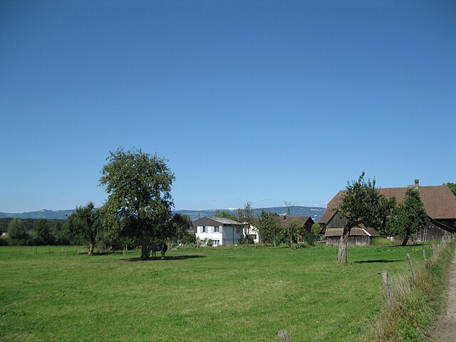
Rohrbach
- municipality in the canton of Bern, Switzerland
Hiking in Rohrbach
Rohrbach, located in the canton of Bern in Switzerland, is a picturesque area ideal for hiking enthusiasts. The region offers a variety of trails that cater to different skill levels, weaving through stunning landscapes including forests, meadows, and views of the surrounding mountains....
- Country:
- Postal Code: 4938
- Local Dialing Code: 062
- Licence Plate Code: BE
- Coordinates: 47° 8' 14" N, 7° 48' 50" E
- GPS tracks (wikiloc): [Link]
- AboveSeaLevel: 584 м m
- Area: 4.1 sq km
- Population: 1469
- Web site: [Link]

Oberbipp
- municipality in Switzerland
Hiking in Oberbipp
Oberbipp, located in the canton of Bern, Switzerland, offers a variety of hiking opportunities that showcase the region's stunning natural beauty. Here are some key points to consider when hiking in Oberbipp:...
- Country:
- Postal Code: 4538
- Local Dialing Code: 032
- Licence Plate Code: BE
- Coordinates: 47° 15' 41" N, 7° 39' 33" E
- GPS tracks (wikiloc): [Link]
- AboveSeaLevel: 454 м m
- Area: 8.5 sq km
- Population: 1733
- Web site: [Link]


Seeberg
- municipality in the canton of Bern, Switzerland
Hiking in Seeberg
Hiking in Seeberg, a beautiful area located in the heart of the Swiss Alps, offers a variety of trails for both novice and experienced hikers. The stunning alpine scenery, lush valleys, and crisp mountain air make it a popular destination for outdoor enthusiasts. Here are some key points about hiking in Seeberg:...
- Country:
- Postal Code: 3365, 3475
- Local Dialing Code: 062
- Licence Plate Code: BE
- Coordinates: 47° 9' 18" N, 7° 39' 53" E
- GPS tracks (wikiloc): [Link]
- AboveSeaLevel: 495 м m
- Area: 16.8 sq km
- Population: 1545
- Web site: [Link]


Thörigen
- municipality in Switzerland
Hiking in Thörigen
Thörigen is a municipality located in the canton of Bern, Switzerland. It's a picturesque area that offers a range of hiking opportunities suited for different skill levels. While the area might not be as widely recognized as some of the more famous Swiss hiking destinations, its natural beauty and serene landscapes make it an excellent choice for outdoor enthusiasts....
- Country:
- Postal Code: 3367
- Local Dialing Code: 062
- Licence Plate Code: BE
- Coordinates: 47° 10' 24" N, 7° 43' 41" E
- GPS tracks (wikiloc): [Link]
- AboveSeaLevel: 486 м m
- Area: 4.53 sq km
- Population: 1127
- Web site: [Link]


Ursenbach
- municipality in the canton of Bern, Switzerland
Hiking in Ursenbach
Ursenbach is a charming village located in the region of Oberaargau in Switzerland, known for its picturesque landscapes, lush forests, and scenic trails. Hiking in and around Ursenbach offers a variety of experiences for outdoor enthusiasts of all levels. Here’s what you can expect when hiking in this area:...
- Country:
- Postal Code: 4937
- Local Dialing Code: 062
- Licence Plate Code: BE
- Coordinates: 47° 7' 46" N, 7° 45' 51" E
- GPS tracks (wikiloc): [Link]
- AboveSeaLevel: 699 м m
- Area: 9.2 sq km
- Population: 905
- Web site: [Link]


Rumisberg
- municipality in Switzerland
Hiking in Rumisberg
Rumisberg is a beautiful location in Switzerland, nestled in the Bernese region. This area is known for its picturesque landscapes, rolling hills, and serene countryside, making it a great spot for hiking enthusiasts of all levels....
- Country:
- Postal Code: 4539
- Local Dialing Code: 032
- Licence Plate Code: BE
- Coordinates: 47° 16' 18" N, 7° 38' 5" E
- GPS tracks (wikiloc): [Link]
- AboveSeaLevel: 824 м m
- Area: 5.2 sq km
- Population: 487
- Web site: [Link]