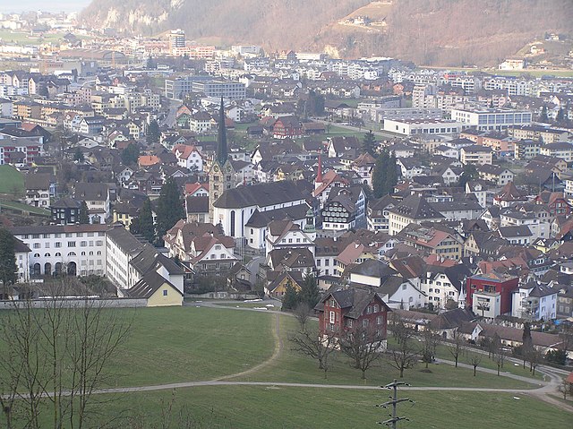
canton of Bern (Kanton Bern)


- canton of Switzerland
 Hiking in canton of Bern
The Canton of Bern, located in Switzerland, offers some of the most stunning landscapes and diverse trails for hiking enthusiasts. This region boasts a mix of alpine scenery, picturesque villages, and lush valleys, making it an excellent destination for all levels of hikers. Here are some highlights you can expect when hiking in the Canton of Bern:
Trails and Areas:
-
Jungfrau Region: This area features iconic peaks like Eiger, Mönch, and Jungfrau. There are numerous trails ranging from easy walks to challenging alpine routes. Popular hikes include the Eiger Trail and the hike from First to Bachalpsee, which showcases stunning mountain views.
-
Thun and Lake Thun: This area offers gentler hikes with beautiful views of Lake Thun and surrounding landscapes. Trails along the lakeshore or up into the nearby hills provide a great way to enjoy the area’s natural beauty.
-
Emmental: Known for its rolling green hills and traditional Swiss farms, Emmental is perfect for those looking for scenic, less strenuous hikes. The Emmental Hiking Trail is particularly popular for its picturesque landscapes and authentic Swiss charm.
-
Gurten: This local mountain near Bern offers easy access for city dwellers. There are well-marked trails on the Gurten and lovely views of the city and the Alps. It's particularly enjoyable for families and those seeking a quick nature escape.
-
Niesen: Often referred to as the "Swiss Pyramid" due to its shape, hiking Niesen can be rewarding. The hike to the summit offers panoramic views of the Bernese Oberland and Lake Thun.
Practical Information:
-
Seasons: The best hiking seasons are typically late spring to early autumn (May to October). However, some high-altitude trails may remain snow-covered until late June or July.
-
Trail Conditions: Most trails are well-marked and maintained. Be sure to check local conditions beforehand, especially in spring and early summer when trails might be muddy or still have snow.
-
Accommodation and Facilities: Many hiking areas in the Canton of Bern have huts and restaurants along the trails. Campsites and hotels can be found in the villages for those looking to extend their hikes over several days.
-
Transport: The Swiss public transportation system is excellent, allowing easy access to many trailheads. Trains and buses connect you to popular hiking areas.
Tips:
- Gear: Make sure to wear appropriate hiking shoes and pack layers since the weather can change quickly in the mountains.
- Safety: Always carry a map or have a navigation app, and inform someone of your hiking plan, especially for longer or more remote hikes.
- Leave No Trace: Respect the environment and local wildlife by following the Leave No Trace principles.
Hiking in the Canton of Bern is not only a chance to explore breathtaking nature but also an opportunity to experience Swiss culture and hospitality. Whether you're a seasoned hiker or a beginner, you'll find something to enjoy in this beautiful region!
- Country:

- Capital: Bern
- Licence Plate Code: BE
- Coordinates: 46° 50' 0" N, 7° 37' 0" E


- GPS tracks (wikiloc): [Link]
- AboveSeaLevel: 542 м m
- Area: 5959 sq km
- Population: 1031126
- Web site: http://www.be.ch
- Wikipedia en: wiki(en)
- Wikipedia: wiki(de)
- Wikidata storage: Wikidata: Q11911
- Wikipedia Commons Gallery: [Link]
- Wikipedia Commons Category: [Link]
- Freebase ID: [/m/01qtj9]
- GeoNames ID: Alt: [2661551]
- BnF ID: [119802858]
- VIAF ID: Alt: [158074156]
- OSM relation ID: [1686344]
- GND ID: Alt: [4005765-3]
- archINFORM location ID: [2705]
- Library of Congress authority ID: Alt: [n80097433]
- MusicBrainz area ID: [df44433e-f5a3-4b06-9518-fb6841c72819]
- Quora topic ID: [Canton-of-Bern]
- TGN ID: [7003742]
- HDS ID: [7383]
- ISNI: Alt: [0000 0001 1421 7081]
- NUTS code: [CH021]
- Ringgold ID: [128900]
- STW Thesaurus for Economics ID: [16959-0]
- ISO 3166-2 code: CH-BE
- FIPS 10-4 (countries and regions): SZ05
Includes regions:

Bernese Jura administrative district
- administrative district of the canton of Bern, Switzerland (Verwaltungskreis)
Hiking in Bernese Jura administrative district
Verwaltungskreis Berner Jura, located in the picturesque region of the Bernese Jura in Switzerland, offers a variety of scenic hiking opportunities. This area is characterized by its rolling hills, lush forests, and stunning views of the surrounding mountains and valleys. Here are some highlights of hiking in this region:...
- Country:
- Capital: Courtelary
- Licence Plate Code: BE
- Coordinates: 47° 12' 11" N, 7° 13' 1" E
- GPS tracks (wikiloc): [Link]


Seeland administrative district
- administrative district of the canton of Bern, Switzerland (Verwaltungskreis)
Hiking in Seeland administrative district
Seeland, located in the Canton of Bern, Switzerland, is a beautiful region that offers a variety of hiking opportunities amidst picturesque landscapes, charming villages, and stunning lake views. Here are some highlights about hiking in Seeland:...
- Country:
- Capital: Aarberg
- Licence Plate Code: BE
- Coordinates: 47° 3' 59" N, 7° 15' 48" E
- GPS tracks (wikiloc): [Link]
- AboveSeaLevel: 442 м m
- Area: 335 sq km

Biel/Bienne administrative district
- administrative district of the canton of Bern, Switzerland (Verwaltungskreis)
Hiking in Biel/Bienne administrative district
Biel/Bienne, located in the canton of Bern in Switzerland, offers a unique blend of French and German culture, and it's also a fantastic destination for hiking enthusiasts. The region is characterized by its stunning landscapes, including the Jura mountains and picturesque lakes, with Lake Biel (Bielersee) serving as a central feature....
- Country:
- Capital: Biel/Bienne
- Licence Plate Code: BE
- Coordinates: 47° 7' 38" N, 7° 15' 42" E
- GPS tracks (wikiloc): [Link]
- AboveSeaLevel: 444 м m
- Area: 98 sq km


Frutigen-Niedersimmental administrative district
- administrative district of the canton of Bern, Switzerland (Verwaltungskreis)
Hiking in Frutigen-Niedersimmental administrative district
Frutigen-Niedersimmental is a picturesque region located in the Bernese Oberland of Switzerland, known for its stunning landscapes, diverse flora and fauna, and a network of well-marked hiking trails. Here are some highlights and tips for hiking in this beautiful area:...
- Country:
- Capital: Frutigen
- Licence Plate Code: BE
- Coordinates: 46° 35' 0" N, 7° 39' 0" E
- GPS tracks (wikiloc): [Link]
- AboveSeaLevel: 1605 м m
- Area: 774 sq km
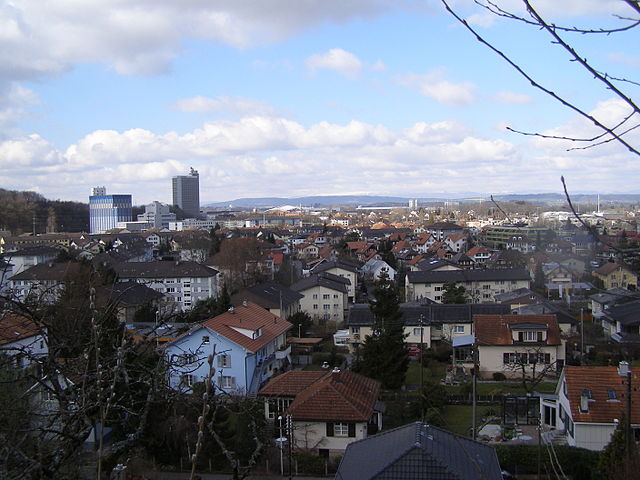

Bern-Mittelland administrative district
- administrative district of the canton of Bern, Switzerland (Verwaltungskreis)
Hiking in Bern-Mittelland administrative district
Bern-Mittelland is a beautiful administrative district in the canton of Bern, Switzerland, that offers a diverse range of hiking opportunities for all levels of hikers. Here are some highlights and tips for hiking in this scenic area:...
- Country:
- Capital: Ostermundigen
- Licence Plate Code: BE
- Coordinates: 46° 57' 17" N, 7° 23' 42" E
- GPS tracks (wikiloc): [Link]
- AboveSeaLevel: 518 м m
- Area: 947 sq km


Emmental administrative district
- administrative district of the canton of Bern, Switzerland (Verwaltungskreis)
Hiking in Emmental administrative district
Emmental, located in the canton of Bern, Switzerland, is a picturesque region renowned for its rolling hills, lush meadows, and stunning landscapes, making it an excellent destination for hiking enthusiasts. Here’s an overview of what you can expect when hiking in Emmental:...
- Country:
- Capital: Langnau im Emmental
- Licence Plate Code: BE
- Coordinates: 47° 2' 39" N, 7° 39' 42" E
- GPS tracks (wikiloc): [Link]
- AboveSeaLevel: 775 м m
- Area: 691 sq km


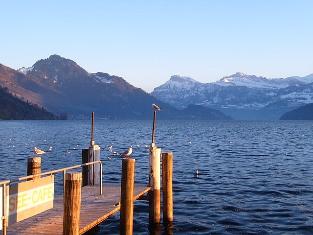
Interlaken-Oberhasli administrative district
- administrative district of the canton of Bern, Switzerland (Verwaltungskreis)
Hiking in Interlaken-Oberhasli administrative district
Interlaken-Oberhasli is a stunning region in the Bernese Oberland of Switzerland, known for its breathtaking landscapes, towering mountains, and picturesque lakes. It offers a plethora of hiking opportunities suitable for all skill levels, from leisurely walks to challenging alpine treks. Here are some highlights and suggestions for hiking in this beautiful district:...
- Country:
- Capital: Interlaken
- Licence Plate Code: BE
- Coordinates: 46° 40' 28" N, 8° 5' 45" E
- GPS tracks (wikiloc): [Link]
- AboveSeaLevel: 2156 м m
- Area: 1229 sq km

Oberaargau administrative district
- administrative district of the canton of Bern, Switzerland (Verwaltungskreis)
Hiking in Oberaargau administrative district
Verwaltungskreis Oberaargau, located in the canton of Aargau in Switzerland, is known for its beautiful landscapes and diverse hiking trails. The region offers a mix of rolling hills, lush forests, and the charm of small Swiss towns, making it a great destination for hikers of all skill levels....
- Country:
- Capital: Wangen an der Aare
- Licence Plate Code: BE
- Coordinates: 47° 11' 12" N, 7° 46' 23" E
- GPS tracks (wikiloc): [Link]

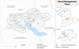
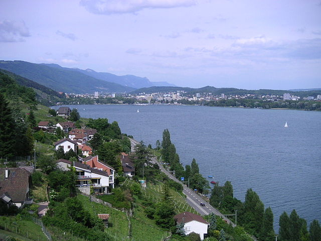
Thun administrative district
- administrative district of the canton of Bern, Switzerland (Verwaltungskreis)
Hiking in Thun administrative district
Thun, located in the Bernese Oberland region of Switzerland, is a beautiful area known for its stunning landscapes, charming town, and access to numerous hiking trails. The administrative district is situated at the shores of Lake Thun, with the picturesque backdrop of the Alps, making it a popular destination for hikers of all levels....
- Country:
- Capital: Thun
- Licence Plate Code: BE
- Coordinates: 46° 45' 0" N, 7° 37' 0" E
- GPS tracks (wikiloc): [Link]
- AboveSeaLevel: 562 м m
- Area: 322 sq km


Obersimmental-Saanen administrative district
- administrative district of the canton of Bern, Switzerland (Verwaltungskreis)
Hiking in Obersimmental-Saanen administrative district
Obersimmental-Saanen is a picturesque region in the Swiss Alps, located in the Bernese Oberland. It's renowned for its stunning landscapes, pristine nature, and a variety of hiking opportunities suitable for all skill levels. Here are some highlights of hiking in this area:...
- Country:
- Capital: Saanen
- Licence Plate Code: BE
- Coordinates: 46° 30' 0" N, 7° 22' 0" E
- GPS tracks (wikiloc): [Link]
- AboveSeaLevel: 1494 м m
- Area: 575 sq km
Shares border with regions:

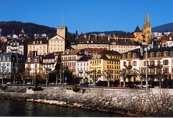
Canton of Solothurn
- canton of Switzerland
Hiking in Canton of Solothurn
Hiking in the Canton of Solothurn offers a fantastic blend of natural beauty, historical sites, and picturesque villages. Located in Switzerland, Solothurn is known for its picturesque landscapes, ranging from rolling hills to stunning valleys and the scenic banks of the River Aare....
- Country:
- Capital: Solothurn
- Licence Plate Code: SO
- Coordinates: 47° 9' 0" N, 7° 38' 0" E
- GPS tracks (wikiloc): [Link]
- AboveSeaLevel: 432 м m
- Area: 790.45 sq km
- Web site: [Link]


Aargau
- canton of Switzerland
Hiking in Aargau
The Canton of Aargau, located in Switzerland, offers a variety of hiking opportunities that cater to different skill levels and preferences. Here's an overview of what you can expect when hiking in this beautiful region:...
- Country:
- Capital: Aarau
- Licence Plate Code: AG
- Coordinates: 47° 22' 49" N, 8° 0' 51" E
- GPS tracks (wikiloc): [Link]
- AboveSeaLevel: 382 м m
- Area: 1403.77 sq km
- Population: 568671
- Web site: [Link]

Canton of Lucerne
- canton of Switzerland
Hiking in Canton of Lucerne
Hiking in the Canton of Lucerne, located in central Switzerland, offers a diverse range of trails that showcase stunning landscapes, picturesque lakes, and the majestic Alps. Here are some highlights and tips for hiking in this beautiful region:...
- Country:
- Capital: Lucerne
- Licence Plate Code: LU
- Coordinates: 47° 5' 0" N, 8° 7' 0" E
- GPS tracks (wikiloc): [Link]
- AboveSeaLevel: 436 м m
- Area: 1493.51 sq km
- Web site: [Link]


Uri
- canton of Switzerland
Hiking in Uri
The Canton of Uri, situated in central Switzerland, offers stunning landscapes and a range of hiking opportunities for all skill levels. Here’s a general overview of hiking in this picturesque region:...
- Country:
- Capital: Altdorf
- Licence Plate Code: UR
- Coordinates: 46° 47' 0" N, 8° 37' 0" E
- GPS tracks (wikiloc): [Link]
- AboveSeaLevel: 447 м m
- Area: 1076.57 sq km
- Population: 36145
- Web site: [Link]

Obwalden
- canton of Switzerland
Hiking in Obwalden
The Canton of Obwalden, located in central Switzerland, is a spectacular area for hiking, characterized by its stunning Alpine landscapes, lush green valleys, and clear lakes. Here are some key highlights and tips for hiking in this beautiful canton:...
- Country:
- Capital: Sarnen
- Licence Plate Code: OW
- Coordinates: 46° 52' 0" N, 8° 2' 0" E
- GPS tracks (wikiloc): [Link]
- AboveSeaLevel: 473 м m
- Area: 490.58 sq km
- Population: 37378
- Web site: [Link]

Nidwalden
- canton of Switzerland
Hiking in Nidwalden
The Canton of Nidwalden, located in central Switzerland, is a true paradise for hikers, offering breathtaking landscapes, diverse trails, and stunning vistas of the surrounding mountains and lakes. Here are some highlights and points of interest for hiking in this beautiful region:...
- Country:
- Capital: Stans
- Licence Plate Code: NW
- Coordinates: 46° 56' 0" N, 8° 4' 0" E
- GPS tracks (wikiloc): [Link]
- AboveSeaLevel: 454 м m
- Area: 275.85 sq km
- Web site: [Link]


Canton of Fribourg
- canton of Switzerland
Hiking in Canton of Fribourg
The Canton of Fribourg, located in western Switzerland, is a fantastic destination for hiking enthusiasts. Known for its diverse landscapes, Fribourg offers a combination of rolling hills, dense forests, and stunning alpine vistas. Here are some highlights and tips for hiking in this beautiful region:...
- Country:
- Capital: Fribourg
- Licence Plate Code: FR
- Coordinates: 46° 43' 0" N, 7° 5' 0" E
- GPS tracks (wikiloc): [Link]
- AboveSeaLevel: 643 м m
- Area: 1671.36 sq km
- Web site: [Link]

Canton of Neuchâtel
- canton of Switzerland
Hiking in Canton of Neuchâtel
The Canton of Neuchâtel, located in western Switzerland, is a stunning area for hiking, featuring a diverse landscape that ranges from rolling hills and deep forests to beautiful lakes and mountainous areas. Here are some highlights and tips for hiking in this picturesque region:...
- Country:
- Capital: Neuchâtel
- Licence Plate Code: NE
- Coordinates: 46° 59' 0" N, 6° 47' 0" E
- GPS tracks (wikiloc): [Link]
- AboveSeaLevel: 430 м m
- Area: 802.24 sq km
- Web site: [Link]


Canton of Jura
- canton of Switzerland
Hiking in Canton of Jura
Hiking in the Canton of Jura, Switzerland, is a fantastic experience for outdoor enthusiasts. This region is known for its stunning landscapes, rolling hills, dense forests, and picturesque Jura mountains. Here are some key points to consider if you're planning to hike in the Canton of Jura:...
- Country:
- Capital: Delémont
- Licence Plate Code: JU
- Coordinates: 47° 22' 0" N, 7° 9' 0" E
- GPS tracks (wikiloc): [Link]
- AboveSeaLevel: 435 м m
- Area: 838.51 sq km
- Population: 69100
- Web site: [Link]


Canton of Vaud
- canton of Switzerland
Hiking in Canton of Vaud
The Canton of Vaud, located in the French-speaking part of Switzerland, is a fantastic destination for hiking enthusiasts. It offers a diverse range of landscapes, from picturesque lakeside trails along Lake Geneva to challenging mountain hikes in the Alps. Here are some highlights of hiking in this beautiful region:...
- Country:
- Capital: Lausanne
- Licence Plate Code: VD
- Coordinates: 46° 37' 0" N, 6° 33' 0" E
- GPS tracks (wikiloc): [Link]
- AboveSeaLevel: 495 м m
- Area: 3212 sq km
- Web site: [Link]


Canton of Valais
- canton of Switzerland
Hiking in Canton of Valais
The Canton of Valais, located in southwestern Switzerland, is a fantastic destination for hiking enthusiasts. Famous for its stunning landscapes dominated by the Alps, the region offers a wide variety of trails suitable for all levels of hikers. Here are some key points to know about hiking in Valais:...
- Country:
- Capital: Sion
- Licence Plate Code: VS
- Coordinates: 46° 4' 0" N, 7° 36' 0" E
- GPS tracks (wikiloc): [Link]
- AboveSeaLevel: 512 м m
- Area: 5224.50 sq km
- Web site: [Link]