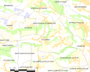
Veyrins-Thuellin (Veyrins-Thuellin)

- former commune in Isère, France
 Hiking in Veyrins-Thuellin
Veyrins-Thuellin is a picturesque commune located in the Auvergne-Rhône-Alpes region of France. It offers several opportunities for hiking enthusiasts to enjoy the beautiful natural landscapes, rolling hills, and scenic views of the nearby mountains, particularly the Chartreuse and the Massif de Belledonne.
Hiking Trails
While the immediate area may not have extensive trails, you can find various paths and trails suitable for hiking. Here are a few points to consider:
-
Local Paths: Explore the local pathways that connect with surrounding villages and natural areas. These paths often feature easy to moderate difficulty levels, ideal for families or casual hikers.
-
Nearby Parks: The proximity to regional parks and natural reserves provides access to more extensive hiking trails. The Chartreuse Regional Natural Park, for instance, has numerous marked trails for different skill levels, from beginner walks to challenging hikes.
-
Scenic Views: Many hikes in the region will reward you with stunning views of the surrounding mountains and valleys. Be sure to bring your camera to capture the stunning scenery!
Facilities and Tips
-
Trail Maps: It's advisable to have a detailed map of the area, which can often be found at local tourist offices or online.
-
Weather Conditions: Always check the weather before heading out, as conditions can change rapidly, especially in mountainous areas.
-
Gear and Supplies: Wear appropriate hiking footwear and clothing. Bring plenty of water, snacks, and a first-aid kit for safety.
-
Respect Nature: Adhere to local guidelines regarding wildlife and stay on marked paths to protect the environment.
Additional Activities
In addition to hiking, Veyrins-Thuellin and its surroundings may offer cycling routes, picnic spots, and opportunities for observing local flora and fauna. This can enhance your outdoor experience and make for a full day of adventure.
Whether you are a seasoned hiker or a beginner looking to enjoy the great outdoors, Veyrins-Thuellin provides a lovely setting to explore nature and experience the region’s charm.
- Country:

- Postal Code: 38630
- Coordinates: 45° 37' 32" N, 5° 32' 21" E


- GPS tracks (wikiloc): [Link]
- AboveSeaLevel: 235 м m
- Area: 11.56 sq km
- Population: 2060
- Web site: http://www.veyrins-thuellin.fr
- Wikipedia en: wiki(en)
- Wikipedia: wiki(fr)
- Wikidata storage: Wikidata: Q974819
- Wikipedia Commons Category: [Link]
- Freebase ID: [/m/03nvjfd]
- GeoNames ID: Alt: [6616684]
- BnF ID: [15258341k]
- VIAF ID: Alt: [234358615]
- INSEE municipality code: 38541
Shares border with regions:


Le Bouchage
- village in Isère, France
Hiking in Le Bouchage
Le Bouchage is a small commune located in the Isère department of the Auvergne-Rhône-Alpes region in southeastern France. While it might not be as well-known as some of the larger towns and national parks in the area, it offers a charming landscape that can appeal to hikers looking for quieter trails and scenic views....
- Country:
- Postal Code: 38510
- Coordinates: 45° 40' 13" N, 5° 31' 33" E
- GPS tracks (wikiloc): [Link]
- Area: 11.2 sq km
- Population: 625
- Web site: [Link]

Dolomieu
- commune in Isère, France
Hiking in Dolomieu
Hiking in Dolomieu, Isère can be a wonderful experience, offering stunning landscapes and diverse trails. While Dolomieu is a small town, it is surrounded by natural beauty and is close to the Vercors and Chartreuse mountain ranges, which provide a variety of hiking opportunities....
- Country:
- Postal Code: 38110
- Coordinates: 45° 36' 39" N, 5° 29' 57" E
- GPS tracks (wikiloc): [Link]
- Area: 13.32 sq km
- Population: 3079
- Web site: [Link]


Corbelin
- commune in Isère, France
Hiking in Corbelin
Corbelin is a charming village located in the Auvergne-Rhône-Alpes region of France, and it offers a variety of outdoor activities, including hiking. The area is known for its scenic landscapes, wooded hills, and proximity to natural reserves, making it an ideal spot for those who enjoy immersing themselves in nature....
- Country:
- Postal Code: 38630
- Coordinates: 45° 36' 27" N, 5° 32' 41" E
- GPS tracks (wikiloc): [Link]
- Area: 12 sq km
- Population: 2223
- Web site: [Link]

Vézeronce-Curtin
- commune in Isère, France
Hiking in Vézeronce-Curtin
Vézeronce-Curtin is a charming village located in the Auvergne-Rhône-Alpes region of France, known for its scenic landscapes and proximity to the beautiful natural areas surrounding it, including the Isère river valley. Here are some details about hiking in and around Vézeronce-Curtin:...
- Country:
- Postal Code: 38510
- Coordinates: 45° 39' 2" N, 5° 28' 14" E
- GPS tracks (wikiloc): [Link]
- AboveSeaLevel: 220 м m
- Area: 14.37 sq km
- Population: 2065
- Web site: [Link]