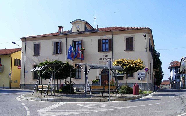
Vigone (Vigone)

- Italian comune
 Hiking in Vigone
Vigone, located in the Piedmont region of Italy, offers a beautiful setting for hiking enthusiasts, especially for those who enjoy traversing through scenic landscapes and charming countryside. While Vigone itself may not be as well-known for extensive hiking trails as some larger national parks or mountain ranges, it provides access to various routes that can cater to different skill levels.
Hiking Highlights in Vigone:
-
Countryside Trails: The area around Vigone is characterized by rolling hills, vineyards, and farmlands. You can find numerous pathways suitable for leisurely walks or more challenging hikes that offer picturesque views of the landscape.
-
Connection to Nearby Regions: Vigone is strategically located near larger hiking areas, such as the Susa Valley and the hills surrounding Turin. From Vigone, you can easily access these regions, which feature well-marked trails, allowing for a more adventurous hiking experience.
-
Nature Reserves: The nearby nature reserves provide a unique opportunity to explore diverse flora and fauna. These parks often have trails that vary in difficulty and length.
-
Historical Hikes: Exploring the rural landscapes can also lead to historical sites, including old churches, castles, and rural farmsteads. Combining history with hiking adds an extra dimension to your experience.
-
Local Guidance: Consider hiring a local guide or joining a hiking group to gain more insight into the area, enhancing your overall experience with local knowledge and expertise.
Tips for Hiking in Vigone:
-
Seasonal Considerations: Spring and early autumn are ideal for hiking, offering pleasant weather and vibrant scenery. Summer can be hot, and winter may bring snow, affecting trail accessibility.
-
Trail Preparation: Familiarize yourself with the chosen trail, ensuring you know its difficulty level and length. Local hiking maps can be extremely useful.
-
Safety: Always carry water, snacks, and a basic first-aid kit. Inform someone about your hiking plans and expected return time.
-
Respect Nature: Stay on marked trails, respect wildlife, and follow local regulations to preserve the beauty of the area.
In summary, while Vigone may not be a prime hiking destination on its own, it is a lovely gateway to explore the beautiful Piedmont region and find unique hiking experiences. Enjoy your adventure!
- Country:

- Postal Code: 10067
- Local Dialing Code: 011
- Licence Plate Code: TO
- Coordinates: 44° 51' 0" N, 7° 30' 0" E


- GPS tracks (wikiloc): [Link]
- AboveSeaLevel: 160 м m
- Area: 41.15 sq km
- Population: 5168
- Web site: http://www.comune.vigone.to.it
- Wikipedia en: wiki(en)
- Wikipedia: wiki(it)
- Wikidata storage: Wikidata: Q10350
- Wikipedia Commons Gallery: [Link]
- Wikipedia Commons Category: [Link]
- Freebase ID: [/m/0g8n5b]
- GeoNames ID: Alt: [6538093]
- VIAF ID: Alt: [147031761]
- OSM relation ID: [43684]
- TGN ID: [7005731]
- UN/LOCODE: [ITVG3]
- ISTAT ID: 001299
- Italian cadastre code: L898
Shares border with regions:


Villafranca Piemonte
- Italian comune
Hiking in Villafranca Piemonte
Villafranca Piemonte is a charming municipality located in the Piedmont region of Italy, not too far from the city of Turin. This area is known for its beautiful landscapes, rich history, and access to various outdoor activities, including hiking. The surrounding countryside features rolling hills, vineyards, and plenty of nature, making it an ideal destination for those who enjoy exploring the great outdoors....
- Country:
- Postal Code: 10068
- Local Dialing Code: 011
- Licence Plate Code: TO
- Coordinates: 44° 47' 0" N, 7° 30' 0" E
- GPS tracks (wikiloc): [Link]
- AboveSeaLevel: 253 м m
- Area: 50.79 sq km
- Population: 4658
- Web site: [Link]
Virle Piemonte
- Italian comune
Hiking in Virle Piemonte
Virle Piemonte is a charming village located in the Piedmont region of Italy, known for its beautiful landscapes and agricultural scenery. While it may not be as popular as some larger tourist destinations, it offers a tranquil hiking experience for those looking to explore the natural beauty and rural charm of northern Italy....
- Country:
- Postal Code: 10060
- Local Dialing Code: 011
- Licence Plate Code: TO
- Coordinates: 44° 52' 0" N, 7° 34' 0" E
- GPS tracks (wikiloc): [Link]
- AboveSeaLevel: 245 м m
- Area: 14.06 sq km
- Population: 1199
- Web site: [Link]


Buriasco
- Italian comune
Hiking in Buriasco
Buriasco is a small municipality located in the province of Turin, in the Piedmont region of Italy. While it may not be as well-known as some of the larger hiking destinations, it offers various opportunities for outdoor enthusiasts, especially for those who enjoy exploring less crowded natural areas....
- Country:
- Postal Code: 10060
- Local Dialing Code: 0121
- Licence Plate Code: TO
- Coordinates: 44° 52' 0" N, 7° 25' 0" E
- GPS tracks (wikiloc): [Link]
- AboveSeaLevel: 301 м m
- Area: 14.69 sq km
- Population: 1370
- Web site: [Link]

Cavour
- Italian comune
Hiking in Cavour
Cavour, located in the Piedmont region of Italy, is a charming town that offers a variety of hiking opportunities for outdoor enthusiasts. Surrounded by beautiful landscapes, including rolling hills, forests, and scenic views of the Alps, Cavour serves as a great base for a range of hiking experiences. Here are some highlights related to hiking in and around Cavour:...
- Country:
- Postal Code: 10061
- Local Dialing Code: 0121
- Licence Plate Code: TO
- Coordinates: 44° 47' 0" N, 7° 23' 0" E
- GPS tracks (wikiloc): [Link]
- AboveSeaLevel: 300 м m
- Area: 48.96 sq km
- Population: 5492
- Web site: [Link]


Cercenasco
- Italian comune
Hiking in Cercenasco
Cercenasco, a municipality in the Metropolitan City of Turin in Italy, offers a beautiful setting for hiking enthusiasts looking to explore the natural beauty of the Piedmont region. The area is characterized by rolling hills, picturesque landscapes, and a rich variety of flora and fauna....
- Country:
- Postal Code: 10060
- Local Dialing Code: 011
- Licence Plate Code: TO
- Coordinates: 44° 52' 0" N, 7° 30' 0" E
- GPS tracks (wikiloc): [Link]
- AboveSeaLevel: 256 м m
- Area: 13.16 sq km
- Population: 1803
- Web site: [Link]

Macello
- Italian comune
Hiking in Macello
It seems like there might be a slight misunderstanding regarding "Macello." If you are referring to a specific location, please clarify, as "Macello" might not be widely recognized as a hiking destination....
- Country:
- Postal Code: 10060
- Local Dialing Code: 0121
- Licence Plate Code: TO
- Coordinates: 44° 51' 0" N, 7° 24' 0" E
- GPS tracks (wikiloc): [Link]
- AboveSeaLevel: 301 м m
- Area: 14.14 sq km
- Population: 1175
- Web site: [Link]


Pancalieri
- Italian comune
Hiking in Pancalieri
Pancalieri is a charming town located in the Piedmont region of Italy, surrounded by picturesque landscapes that make it an appealing destination for hikers. The area is characterized by rolling hills, vast agricultural fields, and scenic views of the nearby mountains....
- Country:
- Postal Code: 10060
- Local Dialing Code: 011
- Licence Plate Code: TO
- Coordinates: 44° 50' 0" N, 7° 35' 0" E
- GPS tracks (wikiloc): [Link]
- AboveSeaLevel: 243 м m
- Area: 15.89 sq km
- Population: 2066
- Web site: [Link]