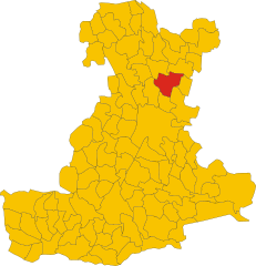
Vigonza (Vigonza)
- Italian comune
Vigonza, located near Padua in the Veneto region of Italy, offers a unique blend of urban and natural landscapes, making it a great spot for hiking enthusiasts. While it may not be as famous for hiking as some of the nearby Alps or the larger hills of the region, there are still some lovely trails and natural areas to explore.
Hiking Trails and Natural Areas
-
Parco della Musica: This park combines nature with artistic installations, making it a pleasant area for leisurely walks or casual hikes. The trails are generally flat and suitable for all skill levels, perfect for families and beginners.
-
Brenta River: Following the Brenta River offers scenic views and a mix of paved pathways and natural trails. You can explore the banks of the river, enjoy the wildlife, and take in the picturesque landscapes.
-
Surrounding Countryside: Vigonza is surrounded by beautiful countryside, where you can find various rural paths that connect small villages. These trails typically wind through fields, vineyards, and olive groves, providing a serene hiking experience.
-
Monte Ceva: A short drive from Vigonza, Monte Ceva offers more challenging hikes and stunning views of the surrounding regions. The trails vary in difficulty and lead through forests with opportunities for wildlife spotting.
Hiking Tips
- Best Time to Hike: Spring (April to June) and early autumn (September to October) are ideal for hiking in Vigonza, as the weather is pleasant and the scenery is vibrant.
- Gear: Wear sturdy hiking boots, especially if you plan to explore rural trails, and bring a good supply of water and snacks.
- Navigation: While many trails are well-marked, it’s a good idea to have a map or a hiking app on your phone to help navigate.
Local Amenities
Vigonza has local amenities, including restaurants and cafes where you can replenish after a hike. Enjoying some local Italian cuisine after a day of hiking is a perfect way to round off your adventure.
Conclusion
While Vigonza may not be a traditional hiking destination, it offers charming walks and trails that are perfect for those looking to enjoy nature without venturing too far from urban conveniences. Whether you're looking for a leisurely stroll or a more vigorous hike, there are options available to suit various preferences.
- Country:

- Postal Code: 35010
- Local Dialing Code: 049
- Licence Plate Code: PD
- Coordinates: 45° 27' 0" N, 11° 59' 0" E


- GPS tracks (wikiloc): [Link]
- AboveSeaLevel: 14 м m
- Area: 33.32 sq km
- Population: 22958
- Web site: http://www.comune.vigonza.pd.it/
- Wikipedia en: wiki(en)
- Wikipedia: wiki(it)
- Wikidata storage: Wikidata: Q34590
- Wikipedia Commons Category: [Link]
- Freebase ID: [/m/0gk60n]
- GeoNames ID: Alt: [6542081]
- VIAF ID: Alt: [124318789]
- OSM relation ID: [44979]
- Quora topic ID: [Vigonza]
- UN/LOCODE: [ITVIZ]
- ISTAT ID: 028100
- Italian cadastre code: L900
Shares border with regions:


Noventa Padovana
- Italian comune
Noventa Padovana is a town in the Veneto region of Italy, located just a few kilometers from the city of Padua. While it is not as mountainous as some regions in Italy, there are still opportunities for enjoyable hikes and nature walks in and around Noventa Padovana. Here are some ideas for hiking-related activities in the area:...
- Country:

- Postal Code: 35027
- Local Dialing Code: 049
- Licence Plate Code: PD
- Coordinates: 45° 24' 51" N, 11° 57' 4" E


- GPS tracks (wikiloc): [Link]
- AboveSeaLevel: 13 м m
- Area: 7.08 sq km
- Population: 11423
- Web site: [Link]
Villanova di Camposampiero
- Italian comune
 Hiking in Villanova di Camposampiero
Villanova di Camposampiero is a charming town in the Veneto region of Italy, situated near Padua. While it may not be as well-known for hiking as other regions in Italy, there are still opportunities to enjoy the outdoors and explore the picturesque countryside....
- Country:

- Postal Code: 35010
- Local Dialing Code: 049
- Licence Plate Code: PD
- Coordinates: 45° 29' 20" N, 11° 58' 29" E


- GPS tracks (wikiloc): [Link]
- AboveSeaLevel: 12 м m
- Area: 12.23 sq km
- Population: 6121
- Web site: [Link]


Campodarsego
- Italian comune
Campodarsego, located in the Veneto region of Italy near Padua, is not widely recognized as a hiking destination due to its flat landscape dominated by agricultural land and small towns. However, it offers opportunities for nature walks and easy hiking experiences, primarily alongside its picturesque countryside, canals, and paths that pass through rural settings....
- Country:

- Postal Code: 35011
- Local Dialing Code: 049
- Licence Plate Code: PD
- Coordinates: 45° 30' 0" N, 11° 55' 0" E


- GPS tracks (wikiloc): [Link]
- AboveSeaLevel: 17 м m
- Area: 25.72 sq km
- Population: 14675
- Web site: [Link]
Cadoneghe
- Italian comune
Cadoneghe, located in the Veneto region of Italy, near the city of Padua, offers a more subdued hiking experience compared to more mountainous areas in the region. However, it does provide opportunities for nature walks and outdoor activities. Here are some highlights and tips for hiking in and around Cadoneghe:...
- Country:

- Postal Code: 35010
- Local Dialing Code: 049
- Licence Plate Code: PD
- Coordinates: 45° 27' 0" N, 11° 56' 0" E


- GPS tracks (wikiloc): [Link]
- AboveSeaLevel: 15 м m
- Area: 12.93 sq km
- Population: 16176
- Web site: [Link]


Pianiga
- Italian comune
Pianiga, located in the Veneto region of Italy, offers a unique hiking experience characterized by its scenic landscapes, charming countryside, and access to the nearby Brenta River. While it may not be as widely known as some other hiking destinations, it boasts a variety of trails suitable for different skill levels....
- Country:

- Postal Code: 30030
- Local Dialing Code: 041
- Licence Plate Code: VE
- Coordinates: 45° 27' 30" N, 12° 0' 29" E


- GPS tracks (wikiloc): [Link]
- AboveSeaLevel: 8 м m
- Area: 20.07 sq km
- Population: 12363
- Web site: [Link]


Fiesso d'Artico
- Italian comune
Fiesso d'Artico is a charming town located in the Veneto region of Italy, situated along the Brenta River. While it is primarily known for its historical significance and proximity to Venice, it offers some appealing opportunities for hiking and outdoor activities in the surrounding areas....
- Country:

- Postal Code: 30032
- Local Dialing Code: 041
- Licence Plate Code: VE
- Coordinates: 45° 25' 0" N, 12° 2' 0" E


- GPS tracks (wikiloc): [Link]
- AboveSeaLevel: 9 м m
- Area: 6.31 sq km
- Population: 8341
- Web site: [Link]


Stra
- Italian comune
Hiking in Stra, a town located near the picturesque Brenta River in the Veneto region of Italy, offers a unique blend of natural beauty and historical charm. While Stra itself is not a primary hiking destination compared to other areas in the region, several nearby trails and points of interest can make for a delightful hiking experience....
- Country:

- Postal Code: 30039
- Local Dialing Code: 049
- Licence Plate Code: VE
- Coordinates: 45° 25' 0" N, 12° 15' 0" E


- GPS tracks (wikiloc): [Link]
- AboveSeaLevel: 9 м m
- Area: 8.82 sq km
- Population: 7635
- Web site: [Link]


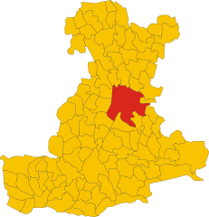
Padua
- capital of the province Padua, Veneto, Italy
Padua, located in the Veneto region of Italy, is not typically known as a primary hiking destination, but it does offer several opportunities for outdoor enthusiasts to explore the surrounding natural beauty. Here are some popular hiking options and tips for hiking around Padua:...
- Country:

- Postal Code: 35121–35143
- Local Dialing Code: 049
- Licence Plate Code: PD
- Coordinates: 45° 24' 23" N, 11° 52' 40" E


- GPS tracks (wikiloc): [Link]
- AboveSeaLevel: 27 м m
- Area: 93.03 sq km
- Population: 211560
- Web site: [Link]
