Villa Latina (Villa Latina)
.svg)
- Italian comune
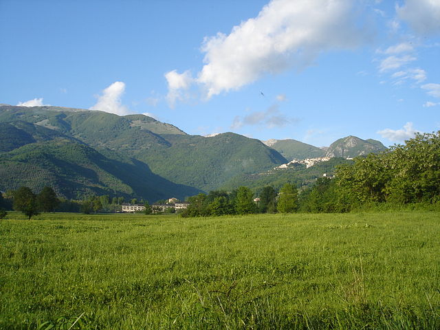
 Hiking in Villa Latina
Villa Latina is a charming location in the Italian region of Lazio, known for its beautiful landscapes and outdoor activities, including hiking. Nestled in the Monti Aurunci National Park, the area offers a variety of trails that cater to different skill levels, making it an excellent destination for both novice and experienced hikers.
Hiking Trails
-
Monte Petrella: One of the most popular hikes, offering stunning vistas of the surrounding mountains and valleys. The trail can be a bit challenging, but the panoramic views from the summit are well worth the effort.
-
Cerro di Campo: This trek is known for its picturesque views and relatively moderate difficulty. The paths are well-marked, leading through lush forests and providing opportunities to observe local wildlife.
-
Valle dell'Inferno: This less-known route takes you through more rugged terrain, featuring striking rock formations and diverse flora. It's perfect for those looking for solitude and a little adventure.
Tips for Hiking in Villa Latina
- Trail Conditions: Always check trail conditions before heading out, as weather can affect accessibility.
- Gear: Wear proper hiking boots and consider bringing trekking poles for stability, especially on steep or rocky sections.
- Water and Snacks: Stay hydrated and carry snacks, as some trails can be longer and more physically demanding than expected.
- Guided Tours: If you're unfamiliar with the area, consider joining a guided hiking tour for safety and to gain insights about the local environment.
Local Attractions
After a day of hiking, you can explore Villa Latina’s charming village, with traditional Italian cuisine and historical sites. It’s a great way to unwind after an adventurous day.
Best Time to Visit
Spring and early autumn are the best times for hiking in Villa Latina, as temperatures are mild and the scenery is particularly beautiful with flowering plants in spring and colorful foliage in the autumn.
Hiking in Villa Latina offers a blend of physical activity, natural beauty, and cultural immersion, making it a rewarding experience for outdoor enthusiasts. Enjoy your adventure!
- Country:

- Postal Code: 03040
- Local Dialing Code: 0776
- Licence Plate Code: FR
- Coordinates: 41° 37' 0" N, 13° 50' 0" E


- GPS tracks (wikiloc): [Link]
- AboveSeaLevel: 415 м m
- Area: 17.02 sq km
- Population: 1217
- Wikipedia en: wiki(en)
- Wikipedia: wiki(it)
- Wikidata storage: Wikidata: Q117593
- Wikipedia Commons Category: [Link]
- Freebase ID: [/m/0gmy1t]
- GeoNames ID: Alt: [6538718]
- VIAF ID: Alt: [236134336]
- OSM relation ID: [41416]
- ISTAT ID: 060088
- Italian cadastre code: A081
Shares border with regions:


Atina, Lazio
- Italian comune
Hiking in Atina, Lazio
Atina, located in the province of Frosinone in the Lazio region of Italy, is a beautiful area known for its stunning landscapes and opportunities for hiking. Nestled in the hills of the Valle di Comino, Atina offers a mix of verdant valleys, rustic villages, and picturesque mountain views, making it an appealing destination for outdoor enthusiasts....
- Country:
- Postal Code: 03042
- Local Dialing Code: 0776
- Licence Plate Code: FR
- Coordinates: 41° 37' 0" N, 13° 48' 0" E
- GPS tracks (wikiloc): [Link]
- AboveSeaLevel: 481 м m
- Area: 29.89 sq km
- Population: 4245
- Web site: [Link]
Belmonte Castello
- Italian comune
Hiking in Belmonte Castello
Belmonte Castello is a charming municipality in Italy, situated within the province of Frosinone in the Lazio region. It offers a variety of hiking opportunities thanks to its picturesque landscapes, hilly terrain, and rich historical context....
- Country:
- Postal Code: 03040
- Local Dialing Code: 0776
- Licence Plate Code: FR
- Coordinates: 41° 35' 0" N, 13° 49' 0" E
- GPS tracks (wikiloc): [Link]
- AboveSeaLevel: 369 м m
- Area: 14.05 sq km
- Population: 708
- Web site: [Link]

Picinisco
- Italian comune
Hiking in Picinisco
Picinisco is a charming village located in the province of Frosinone, in the Lazio region of Italy. Nestled in the Apennine mountains, it offers a variety of hiking opportunities that allow visitors to explore its stunning natural landscapes, rich biodiversity, and historical sites....
- Country:
- Postal Code: 03040
- Local Dialing Code: 0776
- Licence Plate Code: FR
- Coordinates: 41° 39' 0" N, 13° 52' 0" E
- GPS tracks (wikiloc): [Link]
- AboveSeaLevel: 725 м m
- Area: 62.15 sq km
- Population: 1173
- Web site: [Link]


Sant'Elia Fiumerapido
- Italian comune
Hiking in Sant'Elia Fiumerapido
Sant'Elia Fiumerapido, a small town in the province of Frosinone in Italy, offers scenic hiking opportunities, enriched by its picturesque landscapes and proximity to natural attractions. Here are some things to consider while hiking in this area:...
- Country:
- Postal Code: 03049
- Local Dialing Code: 0776
- Licence Plate Code: FR
- Coordinates: 41° 33' 0" N, 13° 52' 0" E
- GPS tracks (wikiloc): [Link]
- AboveSeaLevel: 120 м m
- Area: 41.1 sq km
- Population: 6048
- Web site: [Link]