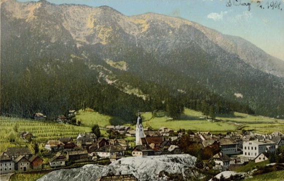
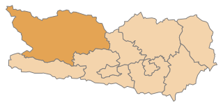
Villach-Land District (Bezirk Villach-Land)

- district of Austria
 Hiking in Villach-Land District
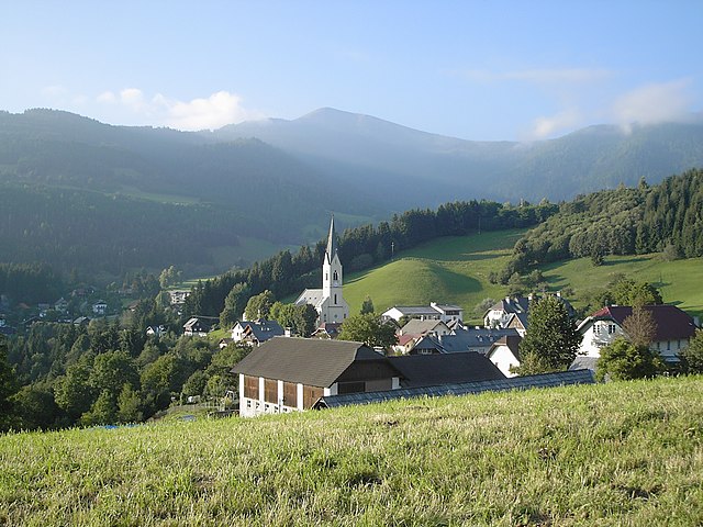
Villach-Land District, located in the southern part of Austria, is a fantastic area for hiking enthusiasts. It is surrounded by stunning natural landscapes, including the Alps, Lake Ossiach, and several picturesque valleys. The diverse terrain offers a wide range of hiking trails suitable for all skill levels, from gentle walks to more challenging mountain hikes.
Key Highlights for Hiking in Villach-Land District:
-
Scenic Views: Many trails provide breathtaking views of the surrounding mountains, lakes, and lush forests. Don't miss the chance to hike along the shores of Lake Ossiach or explore the areas around the Dobratsch Mountain.
-
Variety of Trails: There are numerous marked hiking trails ranging from easy family-friendly routes to more strenuous paths for experienced hikers. You can find circular trails, ridge walks, and forest paths that showcase the beauty of the region.
-
Dobratsch Nature Park: This park is a highlight for many hikers. It features well-maintained trails, including routes that lead to the peak of Dobratsch Mountain, where you can enjoy panoramic views. The park is also rich in flora and fauna, making it a great spot for nature lovers.
-
Cultural Experiences: Along the hiking trails, you may come across traditional Alpine huts and charming villages where you can experience local culture and cuisine. This can enhance your hiking adventure by allowing you to rest and recharge.
-
Water Activities: After a hike, there’s the opportunity to enjoy various water activities on Lake Ossiach, including swimming, kayaking, or simply relaxing by the shore.
-
Seasonal Hiking: Spring and early autumn are particularly beautiful times to hike in the area when the weather is mild, and the landscapes are vibrant. Winter hiking and snowshoeing are also popular, especially in areas that offer winter trails.
Tips for Hiking in Villach-Land District:
- Check Trail Conditions: Before heading out, it's always good to check local trail conditions, especially after heavy rain or snowfall.
- Pack Appropriately: Wear appropriate footwear and clothing for the season. Carry plenty of water, snacks, and a map or GPS device.
- Stay Safe: Make sure to inform someone about your hiking plans, especially if you’re venturing into remote areas.
- Explore Local Resources: Consider visiting local tourism offices or websites for maps, suggested routes, and information on guided hikes.
Overall, hiking in Villach-Land District offers a perfect combination of natural beauty, adventure, and cultural experiences, making it a delightful destination for outdoor enthusiasts. Enjoy your hikes!
- Country:

- Licence Plate Code: VL
- Coordinates: 46° 37' 26" N, 13° 43' 26" E


- GPS tracks (wikiloc): [Link]
- AboveSeaLevel: 535 м m
- Area: 1009.33 sq km
- Population: 64698
- Web site: http://www.bh-villach.ktn.gv.at
- Wikipedia en: wiki(en)
- Wikipedia: wiki(de)
- Wikidata storage: Wikidata: Q660264
- Wikipedia Commons Category: [Link]
- Freebase ID: [/m/0dzv49]
- GeoNames ID: Alt: [2762367]
- archINFORM location ID: [14655]
Includes regions:

Afritz am See
- municipality in Austria
Hiking in Afritz am See
Afritz am See is a picturesque village located in the Carinthia region of Austria, nestled between the Nock Mountains and a serene lake. It offers a variety of hiking opportunities that cater to different skill levels, making it an ideal destination for nature enthusiasts....
- Country:
- Postal Code: 9542
- Local Dialing Code: 04247
- Licence Plate Code: VL
- Coordinates: 46° 43' 39" N, 13° 48' 0" E
- GPS tracks (wikiloc): [Link]
- AboveSeaLevel: 711 м m
- Area: 28.03 sq km
- Population: 1429
- Web site: [Link]
Bad Bleiberg
- municipality in Austria
Hiking in Bad Bleiberg
Bad Bleiberg is a charming village located in the Drau Valley of Carinthia, Austria, known for its beautiful landscapes and outdoor activities, including hiking. The region offers a variety of trails that cater to different skill levels, making it a great destination for both beginners and experienced hikers....
- Country:
- Local Dialing Code: 04244
- Licence Plate Code: VL
- Coordinates: 46° 37' 27" N, 13° 41' 16" E
- GPS tracks (wikiloc): [Link]
- AboveSeaLevel: 902 м m
- Area: 44.8 sq km
- Population: 2283
- Web site: [Link]

Stockenboi
- municipality in Austria
Hiking in Stockenboi
Stockenboi is a beautiful location in Austria, nestled in the stunning landscape of Carinthia. The area is renowned for its outdoor activities, including hiking, which offers a mix of picturesque views, tranquil forests, and a variety of trails catering to different skill levels....
- Country:
- Postal Code: 9714
- Local Dialing Code: 0 47 61
- Licence Plate Code: VL
- Coordinates: 46° 43' 45" N, 13° 34' 50" E
- GPS tracks (wikiloc): [Link]
- AboveSeaLevel: 795 м m
- Area: 100.18 sq km
- Population: 1604
- Web site: [Link]

Paternion
- municipality in Austria
Hiking in Paternion
Paternion, located in the province of Carinthia in Austria, offers a variety of beautiful hiking opportunities that cater to different skill levels. The area is known for its stunning natural beauty, diverse landscapes, and peaceful atmosphere, making it a great destination for both novice and experienced hikers....
- Country:
- Postal Code: 9711
- Local Dialing Code: 04245
- Licence Plate Code: VL
- Coordinates: 46° 42' 44" N, 13° 38' 16" E
- GPS tracks (wikiloc): [Link]
- AboveSeaLevel: 519 м m
- Area: 105.5 sq km
- Population: 5819
- Web site: [Link]

Hohenthurn
- municipality in Austria
Hiking in Hohenthurn
Hohenthurn, a small village in Austria located near the border with Slovenia, is surrounded by beautiful natural landscapes that offer various hiking opportunities. The area is characterized by scenic views, lush forests, and the picturesque backdrop of the Julian Alps....
- Country:
- Postal Code: 9613
- Local Dialing Code: 0 42 56
- Licence Plate Code: VL
- Coordinates: 46° 33' 24" N, 13° 39' 33" E
- GPS tracks (wikiloc): [Link]
- AboveSeaLevel: 620 м m
- Area: 27.16 sq km
- Population: 851
- Web site: [Link]

Velden am Wörther See
- municipality in Austria
Hiking in Velden am Wörther See
Velden am Wörther See is a beautiful destination in Austria, known for its stunning lake and idyllic mountain surroundings. Hiking in this area offers a variety of trails that cater to different skill levels, from easy walks along the lakeshore to more challenging mountain hikes with breathtaking views....
- Country:
- Postal Code: 9220
- Local Dialing Code: 04274
- Licence Plate Code: VL
- Coordinates: 46° 36' 45" N, 14° 2' 31" E
- GPS tracks (wikiloc): [Link]
- AboveSeaLevel: 460 м m
- Area: 53 sq km
- Population: 8952
- Web site: [Link]

Arnoldstein
- municipality in Austria
Hiking in Arnoldstein
Arnoldstein is a charming town located in southern Austria, nestled in the scenic landscapes of Carinthia near the borders of Italy and Slovenia. The region is known for its beautiful hiking trails, offering a mix of stunning views, diverse terrain, and cultural experiences....
- Country:
- Postal Code: 9601
- Local Dialing Code: 04255
- Licence Plate Code: VL
- Coordinates: 46° 33' 2" N, 13° 42' 14" E
- GPS tracks (wikiloc): [Link]
- AboveSeaLevel: 578 м m
- Area: 67.4 sq km
- Population: 7096
- Web site: [Link]

Treffen
- municipality in Austria
Hiking in Treffen
Treffen, located in Austria near Lake Ossiach and not far from the town of Villach, offers a beautiful backdrop for hiking enthusiasts. The area is rich in natural beauty, featuring stunning alpine landscapes, lush forests, and picturesque views of the surrounding mountains....
- Country:
- Postal Code: 9521
- Local Dialing Code: 04248
- Licence Plate Code: VL
- Coordinates: 46° 41' 5" N, 13° 51' 21" E
- GPS tracks (wikiloc): [Link]
- AboveSeaLevel: 1136 м m
- Area: 71.01 sq km
- Population: 4455
- Web site: [Link]

Fresach
- municipality in Austria
Hiking in Fresach
Fresach is a charming village located in Carinthia, Austria, known for its stunning natural landscapes and outdoor activities, including hiking. Here are some key points about hiking in and around Fresach:...
- Country:
- Postal Code: 9712
- Local Dialing Code: 04245
- Licence Plate Code: VL
- Coordinates: 46° 42' 44" N, 13° 41' 33" E
- GPS tracks (wikiloc): [Link]
- AboveSeaLevel: 715 м m
- Area: 38.8 sq km
- Population: 1207
- Web site: [Link]

Ferndorf
- municipality in Austria
Hiking in Ferndorf
Ferndorf, located in Austria, is a beautiful destination for hiking enthusiasts. Nestled in the picturesque landscape of Carinthia, Ferndorf offers a variety of trails that cater to different skill levels, from easy family-friendly walks to more challenging mountain hikes....
- Country:
- Postal Code: 9702
- Local Dialing Code: 0 42 45
- Licence Plate Code: VL
- Coordinates: 46° 44' 10" N, 13° 37' 35" E
- GPS tracks (wikiloc): [Link]
- AboveSeaLevel: 560 м m
- Area: 31.41 sq km
- Population: 2156
- Web site: [Link]

Finkenstein am Faaker See
- municipality in Austria
Hiking in Finkenstein am Faaker See
Finkenstein am Faaker See is a picturesque region located in Carinthia, Austria, known for its stunning landscapes, lakes, and mountains. The area is popular among hikers and outdoor enthusiasts due to its diverse trails and breathtaking views. Here are some highlights and tips for hiking in this beautiful locale:...
- Country:
- Postal Code: 9584
- Local Dialing Code: 04254
- Licence Plate Code: VL
- Coordinates: 46° 33' 46" N, 13° 52' 14" E
- GPS tracks (wikiloc): [Link]
- AboveSeaLevel: 662 м m
- Area: 102 sq km
- Population: 9003
- Web site: [Link]
Sankt Jakob im Rosental
- municipality in Austria
Hiking in Sankt Jakob im Rosental
Sankt Jakob im Rosental is a beautiful village located in the Carinthia region of Austria, surrounded by stunning landscapes and offer a variety of hiking opportunities suitable for all skill levels. Here are some key points about hiking in this area:...
- Country:
- Postal Code: 9184
- Local Dialing Code: 04253
- Licence Plate Code: VL
- Coordinates: 46° 32' 52" N, 14° 3' 26" E
- GPS tracks (wikiloc): [Link]
- AboveSeaLevel: 480 м m
- Area: 78.77 sq km
- Population: 4250
- Web site: [Link]

Feld am See
- municipality in Austria
Hiking in Feld am See
Feld am See, located in the Carinthia region of Austria, is a wonderful destination for hiking enthusiasts. Nestled between the beautiful Lake Feldsee and the surrounding mountains, it offers a variety of trails suitable for different skill levels. Here are some highlights and tips for hiking in this picturesque area:...
- Country:
- Postal Code: 9544
- Local Dialing Code: 0 42 46
- Licence Plate Code: VL
- Coordinates: 46° 46' 32" N, 13° 44' 50" E
- GPS tracks (wikiloc): [Link]
- AboveSeaLevel: 751 м m
- Area: 33.88 sq km
- Population: 1094
- Web site: [Link]

Nötsch im Gailtal
- municipality in Austria
Hiking in Nötsch im Gailtal
Nötsch im Gailtal is a picturesque village located in the Gail Valley of Austria, surrounded by stunning mountain scenery, making it a great destination for hiking enthusiasts. Here are some key points to consider if you're planning to hike in this region:...
- Country:
- Postal Code: 9611
- Licence Plate Code: VL
- Coordinates: 46° 35' 24" N, 13° 37' 22" E
- GPS tracks (wikiloc): [Link]
- AboveSeaLevel: 569 м m
- Area: 42.2 sq km
- Population: 2233
- Web site: [Link]

Wernberg
- municipality in Austria
Hiking in Wernberg
Wernberg, located in the scenic region of Carinthia in Austria, offers beautiful hiking trails that cater to different skill levels and provide stunning views of the surrounding mountains and lakes. Here are some key aspects you might find interesting if you’re considering hiking in Wernberg:...
- Country:
- Postal Code: 9241
- Local Dialing Code: 0 42 52
- Licence Plate Code: VL
- Coordinates: 46° 37' 23" N, 13° 56' 22" E
- GPS tracks (wikiloc): [Link]
- AboveSeaLevel: 590 м m
- Area: 26.42 sq km
- Population: 5587
- Web site: [Link]
Arriach
- municipality in Austria
Hiking in Arriach
Arriach, located in the beautiful Carinthia region of Austria, offers a variety of hiking opportunities surrounded by stunning landscapes, including mountains, forests, and lakes. The area is known for its picturesque trails that cater to different skill levels, making it a great destination for both novice and experienced hikers....
- Country:
- Postal Code: 9543
- Local Dialing Code: 04247
- Licence Plate Code: VL
- Coordinates: 46° 43' 48" N, 13° 51' 1" E
- GPS tracks (wikiloc): [Link]
- AboveSeaLevel: 876 м m
- Area: 70.82 sq km
- Population: 1349
- Web site: [Link]

Rosegg
- municipality in Austria
Hiking in Rosegg
Rosegg, located in Austria's Carinthia region, is a picturesque area that offers a variety of hiking opportunities for enthusiasts of all levels. Nestled near the borders of Slovenia, this charming village is renowned for its stunning natural landscapes, including lush forests, rolling hills, and serene lakes....
- Country:
- Postal Code: 9232
- Licence Plate Code: VL
- Coordinates: 46° 35' 19" N, 14° 1' 7" E
- GPS tracks (wikiloc): [Link]
- AboveSeaLevel: 477 м m
- Area: 19.6 sq km
- Population: 1832
- Web site: [Link]

Weißenstein
- municipality in Austria
Hiking in Weißenstein
Weißenstein, located in the region of Styria, Austria, offers a beautiful natural setting for hiking enthusiasts. This area is characterized by its stunning mountainous landscapes, lush forests, and varied terrain. Here are some highlights and tips for hiking in Weißenstein:...
- Country:
- Postal Code: 9722; 9721; 9710; 9500
- Licence Plate Code: VL
- Coordinates: 46° 40' 56" N, 13° 43' 25" E
- GPS tracks (wikiloc): [Link]
- AboveSeaLevel: 559 м m
- Area: 49.11 sq km
- Population: 2961
- Web site: [Link]

Feistritz an der Gail
- municipality in Austria
Hiking in Feistritz an der Gail
Feistritz an der Gail is a picturesque village located in the heart of the Austrian Alps, within the Carinthia region. It's surrounded by stunning landscapes, making it a great destination for hiking enthusiasts. Here are some highlights of hiking in this area:...
- Country:
- Postal Code: 9613
- Local Dialing Code: 0 42 56
- Licence Plate Code: VL
- Coordinates: 46° 34' 26" N, 13° 36' 14" E
- GPS tracks (wikiloc): [Link]
- AboveSeaLevel: 570 м m
- Area: 19.91 sq km
- Population: 627
- Web site: [Link]
Shares border with regions:

Spittal an der Drau District
- administrative district in Carinthia, Austria
Hiking in Spittal an der Drau District
Spittal an der Drau District, located in the Carinthia region of Austria, is a stunning destination for hiking enthusiasts. Surrounded by the dramatic landscapes of the Alps and lush valleys, this area offers a diverse range of hiking trails suitable for various skill levels, from gentle walks to challenging mountain hikes....
- Country:
- Licence Plate Code: SP
- Coordinates: 46° 49' 59" N, 13° 18' 22" E
- GPS tracks (wikiloc): [Link]
- AboveSeaLevel: 922 м m
- Area: 2764 sq km
- Population: 76248
- Web site: [Link]