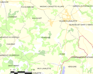
Villebois-Lavalette (Villebois-Lavalette)

- commune in Charente, France
- Country:

- Postal Code: 16320
- Coordinates: 45° 28' 58" N, 0° 16' 46" E


- GPS tracks (wikiloc): [Link]
- AboveSeaLevel: 192 м m
- Area: 7.2 sq km
- Population: 755
- Web site: http://www.villebois-lavalette.com
- Wikipedia en: wiki(en)
- Wikipedia: wiki(fr)
- Wikidata storage: Wikidata: Q837498
- Wikipedia Commons Category: [Link]
- Freebase ID: [/m/03mcfbx]
- GeoNames ID: Alt: [2968866]
- SIREN number: [211604087]
- BnF ID: [152488454]
- PACTOLS thesaurus ID: [pcrti4qX9LEjjM]
- WOEID: [12672448]
- INSEE municipality code: 16408
Shares border with regions:


Gardes-le-Pontaroux
- commune in Charente, France
- Country:
- Postal Code: 16320
- Coordinates: 45° 31' 10" N, 0° 18' 17" E
- GPS tracks (wikiloc): [Link]
- Area: 13.3 sq km
- Population: 268

Ronsenac
- commune in Charente, France
- Country:
- Postal Code: 16320
- Coordinates: 45° 28' 35" N, 0° 15' 0" E
- GPS tracks (wikiloc): [Link]
- Area: 26.73 sq km
- Population: 579
- Web site: [Link]


Magnac-Lavalette-Villars
- commune in Charente, France
- Country:
- Postal Code: 16320
- Coordinates: 45° 30' 2" N, 0° 15' 2" E
- GPS tracks (wikiloc): [Link]
- AboveSeaLevel: 217 м m
- Area: 23.75 sq km
- Population: 434


Blanzaguet-Saint-Cybard
- commune in Charente, France
- Country:
- Postal Code: 16320
- Coordinates: 45° 28' 12" N, 0° 19' 13" E
- GPS tracks (wikiloc): [Link]
- AboveSeaLevel: 102 м m
- Area: 11.95 sq km
- Population: 290
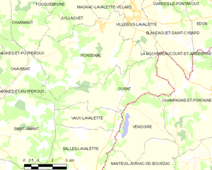
Gurat
- commune in Charente, France
- Country:
- Postal Code: 16320
- Coordinates: 45° 25' 46" N, 0° 16' 11" E
- GPS tracks (wikiloc): [Link]
- Area: 16.03 sq km
- Population: 182