Gardes-le-Pontaroux (Gardes-le-Pontaroux)

- commune in Charente, France
- Country:

- Postal Code: 16320
- Coordinates: 45° 31' 10" N, 0° 18' 17" E


- GPS tracks (wikiloc): [Link]
- Area: 13.3 sq km
- Population: 268
- Wikipedia en: wiki(en)
- Wikipedia: wiki(fr)
- Wikidata storage: Wikidata: Q1470948
- Wikipedia Commons Category: [Link]
- Freebase ID: [/m/03mcb8y]
- GeoNames ID: Alt: [3016660]
- SIREN number: [211601471]
- BnF ID: [15248586w]
- PACTOLS thesaurus ID: [pcrtoJeNR6Hgeu]
- INSEE municipality code: 16147
Shares border with regions:

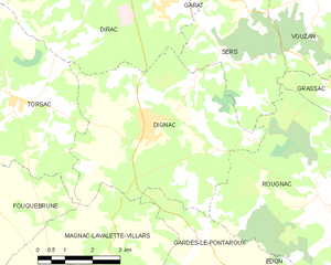
Dignac
- commune in Charente, France
- Country:
- Postal Code: 16410
- Coordinates: 45° 33' 23" N, 0° 16' 49" E
- GPS tracks (wikiloc): [Link]
- Area: 27.66 sq km
- Population: 1315


Édon
- commune in Charente, France
- Country:
- Postal Code: 16320
- Coordinates: 45° 29' 19" N, 0° 21' 15" E
- GPS tracks (wikiloc): [Link]
- Area: 16.49 sq km
- Population: 256


Rougnac
- commune in Charente, France
- Country:
- Postal Code: 16320
- Coordinates: 45° 32' 10" N, 0° 21' 30" E
- GPS tracks (wikiloc): [Link]
- Area: 29.88 sq km
- Population: 410
- Web site: [Link]


Magnac-Lavalette-Villars
- commune in Charente, France
- Country:
- Postal Code: 16320
- Coordinates: 45° 30' 2" N, 0° 15' 2" E
- GPS tracks (wikiloc): [Link]
- AboveSeaLevel: 217 м m
- Area: 23.75 sq km
- Population: 434


Blanzaguet-Saint-Cybard
- commune in Charente, France
- Country:
- Postal Code: 16320
- Coordinates: 45° 28' 12" N, 0° 19' 13" E
- GPS tracks (wikiloc): [Link]
- AboveSeaLevel: 102 м m
- Area: 11.95 sq km
- Population: 290

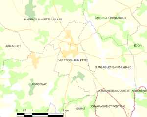
Villebois-Lavalette
- commune in Charente, France
- Country:
- Postal Code: 16320
- Coordinates: 45° 28' 58" N, 0° 16' 46" E
- GPS tracks (wikiloc): [Link]
- AboveSeaLevel: 192 м m
- Area: 7.2 sq km
- Population: 755
- Web site: [Link]