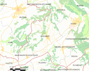
Villedieu (Villedieu)

- commune in Vaucluse, France
 Hiking in Villedieu
Villedieu, located in the Vaucluse department of the Provence-Alpes-Côte d'Azur region in southeastern France, offers some wonderful hiking opportunities amidst its scenic landscapes. The area is characterized by its rolling hills, vineyards, and proximity to the Ventoux mountain range. Here are some highlights of hiking in and around Villedieu:
Trails and Landscapes
-
Local Trails: There are various marked trails around Villedieu that cater to different skill levels. These often lead through vineyards, olive groves, and offer stunning views of the surrounding countryside.
-
Mont Ventoux: A must-visit for hiking enthusiasts is Mont Ventoux, which is a bit further from Villedieu but easily accessible. The climb to the summit is challenging and offers breathtaking views of the landscape below.
-
Luberon Regional Park: To the south, the Luberon Regional Park offers a variety of hiking routes, including picturesque hilltop villages and beautiful natural scenery.
Flora and Fauna
While hiking in this region, you can enjoy the diverse flora and fauna of Provence. Look out for wild lavender, olive trees, and a range of wildlife including birds and small mammals.
Best Times to Hike
The ideal times for hiking in Villedieu are spring (April to June) and fall (September to October) when the weather is typically mild and the landscapes are particularly beautiful with blooming flowers or fall colors.
Practical Information
- Maps and Guides: It’s advisable to carry a good map or use a hiking app to ensure you stay on the trails, as some paths may not be well-marked.
- Local Amenities: Villedieu has small shops and cafés where you can rest and refuel after a hike.
Safety Tips
- Stay Hydrated: It's important to carry enough water, especially during the warmer months.
- Dress Appropriately: Wear sturdy hiking shoes and dress in layers; temperatures can vary significantly.
- Check Weather Conditions: Weather can change rapidly, especially in the mountains, so always check forecasts before heading out.
Hiking in Villedieu can provide a peaceful and rewarding experience, allowing you to connect with nature while exploring the charm of Provence.
- Country:

- Postal Code: 84110
- Coordinates: 44° 17' 2" N, 5° 2' 5" E


- GPS tracks (wikiloc): [Link]
- Area: 11.38 sq km
- Population: 521
- Wikipedia en: wiki(en)
- Wikipedia: wiki(fr)
- Wikidata storage: Wikidata: Q625740
- Wikipedia Commons Category: [Link]
- Freebase ID: [/m/0cf7_y]
- GeoNames ID: Alt: [6445123]
- SIREN number: [218401461]
- BnF ID: [15278126j]
- INSEE municipality code: 84146
Shares border with regions:

Vinsobres
- commune in Drôme, France
Hiking in Vinsobres
Vinsobres is a picturesque village located in the Provence region of southeastern France, nestled in the foothills of the Baronnies mountains. This charming area offers a variety of hiking opportunities suitable for different skill levels, making it a great destination for both casual walkers and experienced hikers....
- Country:
- Postal Code: 26110
- Coordinates: 44° 20' 1" N, 5° 3' 40" E
- GPS tracks (wikiloc): [Link]
- Area: 35.42 sq km
- Population: 1171
- Web site: [Link]


Saint-Maurice-sur-Eygues
- commune in Drôme, France
Hiking in Saint-Maurice-sur-Eygues
Saint-Maurice-sur-Eygues is a charming village located in the Drôme department of the Auvergne-Rhône-Alpes region in southeastern France. The region offers beautiful landscapes, diverse flora and fauna, and a variety of hiking opportunities that cater to different skill levels....
- Country:
- Postal Code: 26110
- Coordinates: 44° 17' 54" N, 5° 0' 39" E
- GPS tracks (wikiloc): [Link]
- Area: 8.82 sq km
- Population: 760
- Web site: [Link]


Buisson
- commune in Vaucluse, France
Hiking in Buisson
Buisson, located in the Vaucluse department of the Provence-Alpes-Côte d'Azur region in southeastern France, is known for its beautiful landscapes and scenic hiking opportunities. The area offers a mix of natural beauty, historical sites, and charming villages, making it an attractive destination for hikers of all levels....
- Country:
- Postal Code: 84110
- Coordinates: 44° 16' 49" N, 4° 59' 52" E
- GPS tracks (wikiloc): [Link]
- Area: 9.49 sq km
- Population: 294


Saint-Romain-en-Viennois
- commune in Vaucluse, France
Hiking in Saint-Romain-en-Viennois
Saint-Romain-en-Viennois is a charming village located in the Vaucluse department in the Provence-Alpes-Côte d'Azur region of southeastern France. Its picturesque landscape, set against the backdrop of the Ventoux Mountain and lush vineyards, offers a variety of hiking opportunities that cater to different skill levels....
- Country:
- Postal Code: 84110
- Coordinates: 44° 15' 29" N, 5° 6' 35" E
- GPS tracks (wikiloc): [Link]
- Area: 9 sq km
- Population: 832

Vaison-la-Romaine
- commune in Vaucluse, France
Hiking in Vaison-la-Romaine
Vaison-la-Romaine, located in the Provence-Alpes-Côte d'Azur region of France, offers a rich blend of historical charm and natural beauty, making it a great destination for hiking enthusiasts. Here are some highlights of hiking in and around Vaison-la-Romaine:...
- Country:
- Postal Code: 84110
- Coordinates: 44° 14' 27" N, 5° 4' 30" E
- GPS tracks (wikiloc): [Link]
- Area: 26.99 sq km
- Population: 6072
- Web site: [Link]


Puyméras
- commune in Vaucluse, France
Hiking in Puyméras
Puyméras is a charming village located in the Vaucluse department of the Provence-Alpes-Côte d'Azur region in southeastern France. This picturesque area is surrounded by beautiful landscapes, making it an appealing destination for hiking enthusiasts. Here are some highlights and tips for hiking around Puyméras:...
- Country:
- Postal Code: 84110
- Coordinates: 44° 16' 12" N, 5° 7' 41" E
- GPS tracks (wikiloc): [Link]
- Area: 14.59 sq km
- Population: 603

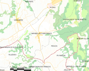
Mirabel-aux-Baronnies
- commune in Drôme, France
Hiking in Mirabel-aux-Baronnies
Mirabel-aux-Baronnies, located in the Vaucluse department of the Provence-Alpes-Côte d'Azur region in southeastern France, offers a wonderful array of hiking opportunities that showcase the natural beauty and diverse landscapes of the area. Here are some things to know about hiking in and around Mirabel-aux-Baronnies:...
- Country:
- Postal Code: 26110
- Coordinates: 44° 18' 39" N, 5° 5' 57" E
- GPS tracks (wikiloc): [Link]
- Area: 22.56 sq km
- Population: 1569