Villers-Écalles (Villers-Écalles)

- commune in Seine-Maritime, France
- Country:

- Postal Code: 76360
- Coordinates: 49° 32' 19" N, 0° 55' 9" E


- GPS tracks (wikiloc): [Link]
- Area: 7.41 sq km
- Population: 1778
- Web site: http://www.villers-ecalles.fr
- Wikipedia en: wiki(en)
- Wikipedia: wiki(fr)
- Wikidata storage: Wikidata: Q1422288
- Wikipedia Commons Category: [Link]
- Freebase ID: [/m/03qgjs8]
- GeoNames ID: Alt: [6443583]
- SIREN number: [217607431]
- BnF ID: [152753251]
- PACTOLS thesaurus ID: [pcrtXOFSUArR9R]
- INSEE municipality code: 76743
Shares border with regions:


Bouville
- commune in Seine-Maritime, France
- Country:
- Postal Code: 76360
- Coordinates: 49° 33' 45" N, 0° 53' 37" E
- GPS tracks (wikiloc): [Link]
- Area: 12.48 sq km
- Population: 970

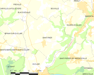
Saint-Paër
- commune in Seine-Maritime, France
- Country:
- Postal Code: 76480
- Coordinates: 49° 31' 0" N, 0° 52' 45" E
- GPS tracks (wikiloc): [Link]
- Area: 18.36 sq km
- Population: 1352
- Web site: [Link]
Saint-Pierre-de-Varengeville
- commune in Seine-Maritime, France
- Country:
- Postal Code: 76480
- Coordinates: 49° 30' 6" N, 0° 55' 58" E
- GPS tracks (wikiloc): [Link]
- Area: 13.18 sq km
- Population: 2343
- Web site: [Link]
Mesnil-Panneville
- commune in Seine-Maritime, France
- Country:
- Postal Code: 76570
- Coordinates: 49° 35' 29" N, 0° 53' 28" E
- GPS tracks (wikiloc): [Link]
- Area: 11.87 sq km
- Population: 694


Barentin
- commune in Seine-Maritime, France
- Country:
- Postal Code: 76360
- Coordinates: 49° 32' 40" N, 0° 57' 13" E
- GPS tracks (wikiloc): [Link]
- Area: 12.74 sq km
- Population: 12249
- Web site: [Link]