Villers-aux-Érables (Villers-aux-Érables)

- commune in Somme, France
- Country:

- Postal Code: 80110
- Coordinates: 49° 47' 15" N, 2° 32' 13" E


- GPS tracks (wikiloc): [Link]
- Area: 4.34 sq km
- Population: 126
- Web site: http://mairie.villers-aux-erables.pagespro-orange.fr/
- Wikipedia en: wiki(en)
- Wikipedia: wiki(fr)
- Wikidata storage: Wikidata: Q887694
- Wikipedia Commons Category: [Link]
- Freebase ID: [/m/03qmr7h]
- GeoNames ID: Alt: [6444795]
- SIREN number: [218007482]
- BnF ID: [15277268h]
- INSEE municipality code: 80797
Shares border with regions:


Moreuil
- commune in Somme, France
- Country:
- Postal Code: 80110
- Coordinates: 49° 46' 28" N, 2° 28' 59" E
- GPS tracks (wikiloc): [Link]
- Area: 23.43 sq km
- Population: 4007
- Web site: [Link]

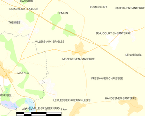
Mézières-en-Santerre
- commune in Somme, France
- Country:
- Postal Code: 80110
- Coordinates: 49° 47' 10" N, 2° 33' 18" E
- GPS tracks (wikiloc): [Link]
- Area: 10.71 sq km
- Population: 578


Démuin
- commune in Somme, France
- Country:
- Postal Code: 80110
- Coordinates: 49° 49' 13" N, 2° 32' 12" E
- GPS tracks (wikiloc): [Link]
- Area: 11.23 sq km
- Population: 479
- Web site: [Link]


Domart-sur-la-Luce
- commune in Somme, France
- Country:
- Postal Code: 80110
- Coordinates: 49° 49' 13" N, 2° 29' 4" E
- GPS tracks (wikiloc): [Link]
- Area: 8.59 sq km
- Population: 437
- Web site: [Link]

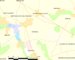
Thennes
- commune in Somme, France
- Country:
- Postal Code: 80110
- Coordinates: 49° 48' 39" N, 2° 28' 14" E
- GPS tracks (wikiloc): [Link]
- Area: 8 sq km
- Population: 506