Vouthon-Bas (Vouthon-Bas)

- commune in Meuse, France
- Country:

- Postal Code: 55130
- Coordinates: 48° 29' 0" N, 5° 36' 30" E


- GPS tracks (wikiloc): [Link]
- Area: 7.22 sq km
- Population: 51
- Wikipedia en: wiki(en)
- Wikipedia: wiki(fr)
- Wikidata storage: Wikidata: Q1157913
- Wikipedia Commons Category: [Link]
- Freebase ID: [/m/03qdvsw]
- GeoNames ID: Alt: [6437271]
- SIREN number: [215505744]
- BnF ID: [15265238w]
- INSEE municipality code: 55574
Shares border with regions:
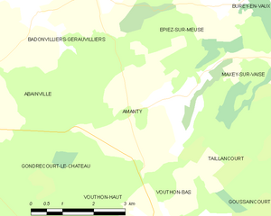
Amanty
- commune in Meuse, France
- Country:
- Postal Code: 55130
- Coordinates: 48° 31' 5" N, 5° 36' 41" E
- GPS tracks (wikiloc): [Link]
- Area: 11.17 sq km
- Population: 42


Taillancourt
- commune in Meuse, France
- Country:
- Postal Code: 55140
- Coordinates: 48° 31' 52" N, 5° 41' 39" E
- GPS tracks (wikiloc): [Link]
- Area: 11.09 sq km
- Population: 134


Vouthon-Haut
- commune in Meuse, France
- Country:
- Postal Code: 55130
- Coordinates: 48° 28' 36" N, 5° 37' 3" E
- GPS tracks (wikiloc): [Link]
- Area: 13.23 sq km
- Population: 78


Goussaincourt
- commune in Meuse, France
- Country:
- Postal Code: 55140
- Coordinates: 48° 29' 6" N, 5° 41' 20" E
- GPS tracks (wikiloc): [Link]
- Area: 10.33 sq km
- Population: 123