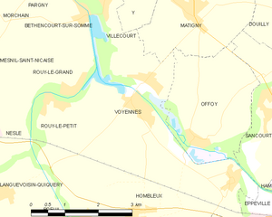
Voyennes (Voyennes)
- commune in Somme, France
- Country:

- Postal Code: 80400
- Coordinates: 49° 46' 19" N, 2° 59' 0" E


- GPS tracks (wikiloc): [Link]
- Area: 8.87 sq km
- Population: 619
- Web site: http://www.commune-voyennes.fr
- Wikipedia en: wiki(en)
- Wikipedia: wiki(fr)
- Wikidata storage: Wikidata: Q885999
- Wikipedia Commons Category: [Link]
- Freebase ID: [/m/03qmrsb]
- GeoNames ID: Alt: [2967590]
- SIREN number: [218007623]
- BnF ID: [152772822]
- PACTOLS thesaurus ID: [pcrtLXnP98e7ag]
- INSEE municipality code: 80811
Shares border with regions:


Béthencourt-sur-Somme
- commune in Somme, France
- Country:

- Postal Code: 80190
- Coordinates: 49° 47' 41" N, 2° 57' 49" E


- GPS tracks (wikiloc): [Link]
- Area: 2.87 sq km
- Population: 130


Matigny
- commune in Somme, France
- Country:

- Postal Code: 80400
- Coordinates: 49° 47' 44" N, 3° 0' 29" E


- GPS tracks (wikiloc): [Link]
- Area: 6.99 sq km
- Population: 498


Offoy
- commune in Somme, France
- Country:

- Postal Code: 80400
- Coordinates: 49° 45' 40" N, 3° 0' 40" E


- GPS tracks (wikiloc): [Link]
- Area: 7.1 sq km
- Population: 226


Hombleux
- commune in Somme, France
- Country:

- Postal Code: 80400
- Coordinates: 49° 44' 19" N, 2° 59' 7" E


- GPS tracks (wikiloc): [Link]
- Area: 15.81 sq km
- Population: 1142
- Web site: [Link]


Rouy-le-Grand
- commune in Somme, France
- Country:

- Postal Code: 80190
- Coordinates: 49° 46' 31" N, 2° 57' 32" E


- GPS tracks (wikiloc): [Link]
- Area: 3.81 sq km
- Population: 109
- Web site: [Link]


Rouy-le-Petit
- commune in Somme, France
- Country:

- Postal Code: 80190
- Coordinates: 49° 46' 23" N, 2° 56' 56" E


- GPS tracks (wikiloc): [Link]
- Area: 3.27 sq km
- Population: 117


Villecourt
- commune in Somme, France
- Country:

- Postal Code: 80190
- Coordinates: 49° 47' 59" N, 2° 58' 16" E


- GPS tracks (wikiloc): [Link]
- Area: 2.19 sq km
- Population: 58
