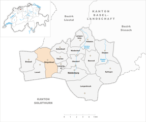
Waldenburg (Waldenburg)

- municipality in the canton Basel-Landschaft, Switzerland
 Hiking in Waldenburg
Waldenburg is a picturesque village located in the Basel-Landschaft region of Switzerland. The area is known for its stunning landscapes and scenic hiking trails that cater to various skill levels. Here’s what you can expect when hiking in and around Waldenburg:
Trails and Scenery
-
Panoramic Views: Many trails around Waldenburg offer breathtaking views of the Jura Mountains and the surrounding countryside. The elevation changes provide excellent vantage points for photography and simply enjoying nature.
-
Nature and Wildlife: The region is rich in biodiversity, and while hiking, you may encounter diverse flora and fauna. Keep an eye out for various bird species and perhaps even some local deer or foxes.
-
Marked Hiking Trails: The area has a well-maintained network of marked hiking trails, which can range from easy valley walks to more challenging mountain hikes. Trails are usually well-signposted, making navigation straightforward.
Popular Hikes
- Waldenburg-Walneberg Trail: A moderate hike that provides a good overview of the region and passes through dense forests and open meadows.
- Hiking to Liestal: This trail takes you from Waldenburg to the nearby town of Liestal, offering a mix of forest paths and farmland.
Tips for Hiking in Waldenburg
- Weather Preparation: Swiss weather can be unpredictable, so check the forecast before heading out. Layer your clothing to adjust to varying temperatures.
- Hydrate and Fuel Up: Bring enough water and snacks to keep your energy up, especially on longer hikes.
- Safety First: Always inform someone of your hiking plans and consider going with a companion. While trails are generally safe, it’s important to be cautious.
Getting There
Waldenburg is accessible by train and bus from major Swiss cities. The hiking trails are usually reachable from the village itself, making it a convenient starting point for your adventures.
Conclusion
Hiking in Waldenburg offers a serene experience in nature with a backdrop of beautiful landscapes. Whether you're an experienced hiker or just looking for a leisurely walk, there's something for everyone in this charming Swiss village. Enjoy your hike!
- Country:

- Postal Code: 4437
- Local Dialing Code: 061
- Licence Plate Code: BL
- Coordinates: 47° 22' 59" N, 7° 45' 0" E


- GPS tracks (wikiloc): [Link]
- AboveSeaLevel: 693 м m
- Area: 8.30 sq km
- Population: 1125
- Web site: http://www.waldenburg.ch
- Wikipedia en: wiki(en)
- Wikipedia: wiki(de)
- Wikidata storage: Wikidata: Q67092
- Wikipedia Commons Category: [Link]
- Freebase ID: [/m/01_yjb]
- GeoNames ID: Alt: [7287520]
- BnF ID: [120323351]
- VIAF ID: Alt: [125620469]
- OSM relation ID: [1683719]
- GND ID: Alt: [4118962-0]
- MusicBrainz area ID: [35b65b50-7006-4897-b8bf-d3c7d8821092]
- HDS ID: [7559]
- Swiss municipality code: [2895]
Shares border with regions:

Reigoldswil
- municipality in Switzerland
Hiking in Reigoldswil
Reigoldswil is a charming village in the beautiful Basel-Landschaft region of Switzerland, known for its stunning natural landscapes, rolling hills, and proximity to the Jura mountains. Hiking in and around Reigoldswil offers a variety of trails that cater to different skill levels and preferences....
- Country:
- Postal Code: 4418
- Local Dialing Code: 061
- Licence Plate Code: BL
- Coordinates: 47° 23' 45" N, 7° 41' 24" E
- GPS tracks (wikiloc): [Link]
- AboveSeaLevel: 538 м m
- Area: 9.25 sq km
- Population: 1613
- Web site: [Link]


Langenbruck
- municipality in Switzerland
Hiking in Langenbruck
Langenbruck, located in the beautiful region of the Swiss Jura Mountains, offers a range of hiking opportunities for all levels of experience. The scenic landscapes feature rolling hills, lush forests, and panoramic views of the surrounding mountains. Here are some key points to keep in mind when planning a hike in Langenbruck:...
- Country:
- Postal Code: 4438
- Local Dialing Code: 062
- Licence Plate Code: BL
- Coordinates: 47° 21' 29" N, 7° 46' 15" E
- GPS tracks (wikiloc): [Link]
- AboveSeaLevel: 758 м m
- Area: 15.69 sq km
- Population: 957
- Web site: [Link]


Oberdorf
- municipality in the canton Basel-Landschaft, Switzerland
Hiking in Oberdorf
Oberdorf, located in the Basel-Landschaft region of Switzerland, offers an excellent environment for hiking enthusiasts. The area is characterized by its picturesque landscapes, rolling hills, and lush forests, making it a great destination for both casual walkers and experienced hikers....
- Country:
- Postal Code: 4436
- Local Dialing Code: 061
- Licence Plate Code: BL
- Coordinates: 47° 23' 31" N, 7° 45' 5" E
- GPS tracks (wikiloc): [Link]
- AboveSeaLevel: 497 м m
- Area: 6.19 sq km
- Population: 2409
- Web site: [Link]


Liedertswil
- municipality in Switzerland
Hiking in Liedertswil
Liedertswil is a small village located in the picturesque region of the Swiss countryside, known for its scenic landscapes and hiking trails. Situated in the canton of Aargau, this area offers a variety of hiking options that cater to all levels of experience. Here are some highlights of hiking in and around Liedertswil:...
- Country:
- Postal Code: 4436
- Local Dialing Code: 061
- Licence Plate Code: BL
- Coordinates: 47° 23' 18" N, 7° 43' 12" E
- GPS tracks (wikiloc): [Link]
- AboveSeaLevel: 760 м m
- Area: 1.94 sq km
- Population: 169
- Web site: [Link]