
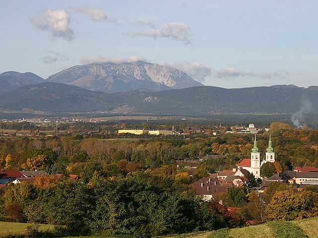
Wiener Neustadt (Wiener Neustadt)

- city in Lower Austria, Austria
 Hiking in Wiener Neustadt
Wiener Neustadt, located in Lower Austria, offers several hiking opportunities for outdoor enthusiasts. The region is characterized by a mix of stunning natural landscapes, historical sites, and diverse trails suitable for various skill levels. Here are some highlights and tips for hiking in Wiener Neustadt:
Trail Options:
-
Vienna Woods Trails: The nearby Vienna Woods (Wienerwald) have numerous hiking trails that cater to all levels. These trails provide a chance to enjoy rich forested areas, peaceful locations, and picturesque views.
-
Thermal Region: The area surrounding Wiener Neustadt features several trails that lead through picturesque landscapes with a mix of vineyards, meadows, and rolling hills, revealing the beauty of the thermal region.
-
Burgruine Strasshof: A popular hiking destination, this ruins trail provides both historical interest and beautiful views of the surrounding countryside, making it ideal for history buffs and nature lovers alike.
-
Wanderwege: There are designated Wanderwege (hiking paths) in and around Wiener Neustadt, some of which include educational signs about local flora, fauna, and geological features.
Scenic Spots:
- Hochschwab Range: In the nearby mountains, you can enjoy breathtaking panoramic views.
- Lake Neusiedl: A little further afield, this lake offers beautiful trails and opportunities for birdwatching.
Hiking Tips:
- Preparation: Always check the weather before heading out, as conditions can change. Wear appropriate footwear and clothing for the terrain and forecast.
- Maps and Guides: Consider bringing a map or downloading a hiking app to help you navigate the trails. Local tourism offices may have brochures with trail suggestions.
- Safety: Carry enough water and snacks, and let someone know your planned route and estimated return time.
- Respect Nature: Stay on marked trails, pack out what you bring in, and adhere to local regulations to help preserve the natural beauty of the area.
Local Amenities:
Wiener Neustadt offers a range of amenities such as accommodation, restaurants, and transportation, making it a great base for exploring the hiking trails in the region.
Overall, Wiener Neustadt provides a fantastic setting for hikers looking to explore the beauty of Lower Austria, with a wide variety of trails and stunning landscapes waiting to be discovered!
- Country:

- Postal Code: 2700
- Local Dialing Code: 02622
- Licence Plate Code: WN
- Coordinates: 47° 49' 0" N, 16° 15' 0" E


- GPS tracks (wikiloc): [Link]
- AboveSeaLevel: 265 м m
- Area: 60.94 sq km
- Population: 44461
- Web site: http://www.wiener-neustadt.at/
- Wikipedia en: wiki(en)
- Wikipedia: wiki(de)
- Wikidata storage: Wikidata: Q131612
- Wikipedia Commons Gallery: [Link]
- Wikipedia Commons Category: [Link]
- Freebase ID: [/m/03_sg1]
- GeoNames ID: Alt: [2761349]
- VIAF ID: Alt: [239453006]
- GND ID: Alt: [4066023-0]
- archINFORM location ID: [9912]
- MusicBrainz area ID: [a80ef162-5c86-49bb-a2da-8049ab479f8a]
- Quora topic ID: [Wiener-Neustadt]
- Facebook Places ID: [111788332180008]
- Austrian municipality key: [30401]
Shares border with regions:
Breitenau, Lower Austria
- municipality in Austria
Hiking in Breitenau, Lower Austria
Breitenau, located in Lower Austria, offers picturesque hiking opportunities amidst stunning natural landscapes. The region is characterized by rolling hills, lush forests, and beautiful meadows. Here are some highlights of hiking in Breitenau:...
- Country:
- Postal Code: 2624
- Local Dialing Code: 02635
- Licence Plate Code: NK
- Coordinates: 47° 44' 0" N, 16° 9' 0" E
- GPS tracks (wikiloc): [Link]
- AboveSeaLevel: 343 м m
- Area: 9.63 sq km
- Population: 1576
- Web site: [Link]

Lichtenwörth
- municipality in Austria
Hiking in Lichtenwörth
Lichtenwörth is a charming municipality located in Austria, not far from the city of Wiener Neustadt. The surrounding landscape offers a variety of hiking trails suitable for different skill levels, making it a great destination for both beginners and experienced hikers....
- Country:
- Local Dialing Code: 02622
- Licence Plate Code: WB
- Coordinates: 47° 49' 55" N, 16° 17' 44" E
- GPS tracks (wikiloc): [Link]
- AboveSeaLevel: 254 м m
- Area: 22.91 sq km
- Population: 2727
- Web site: [Link]

Neudörfl
- municipality in Austria
Hiking in Neudörfl
Neudörfl is a charming village located in the Burgenland region of Austria. Surrounded by natural beauty and a tranquil countryside, it offers various opportunities for hiking enthusiasts. Here are some key points to consider when hiking in and around Neudörfl:...
- Country:
- Postal Code: 7201
- Local Dialing Code: 02622
- Licence Plate Code: MA
- Coordinates: 47° 47' 52" N, 16° 17' 48" E
- GPS tracks (wikiloc): [Link]
- AboveSeaLevel: 273 м m
- Area: 9.01 sq km
- Population: 4564
- Web site: [Link]

Katzelsdorf
- municipality in Austria
Hiking in Katzelsdorf
Katzelsdorf, located in Austria's Lower Austria region, offers a beautiful setting for hiking enthusiasts. The area is known for its picturesque landscapes, rolling hills, and access to various trails suitable for different skill levels....
- Country:
- Local Dialing Code: 02622
- Licence Plate Code: WB
- Coordinates: 47° 46' 44" N, 16° 16' 25" E
- GPS tracks (wikiloc): [Link]
- AboveSeaLevel: 273 м m
- Area: 16.25 sq km
- Population: 3257
- Web site: [Link]
Felixdorf
- municipality in Austria
Hiking in Felixdorf
Felixdorf, located in Lower Austria, is a charming area that provides a variety of hiking opportunities, appealing to both novice and seasoned hikers. Nestled near the foothills of the Vienna Woods, this region boasts beautiful landscapes, forests, and scenic trails that are perfect for outdoor enthusiasts....
- Country:
- Postal Code: 2603
- Local Dialing Code: 02628
- Licence Plate Code: WB
- Coordinates: 47° 53' 0" N, 16° 14' 0" E
- GPS tracks (wikiloc): [Link]
- AboveSeaLevel: 282 м m
- Area: 2.54 sq km
- Population: 4292
- Web site: [Link]
Schwarzau am Steinfeld
- municipality in Austria
Hiking in Schwarzau am Steinfeld
Schwarzau am Steinfeld is a picturesque village located in the Lower Austria region of Austria, surrounded by stunning natural landscapes that are perfect for hiking enthusiasts. The area features a variety of trails that cater to different skill levels, making it suitable for both beginners and experienced hikers....
- Country:
- Local Dialing Code: 02627
- Licence Plate Code: NK
- Coordinates: 47° 43' 0" N, 16° 10' 0" E
- GPS tracks (wikiloc): [Link]
- AboveSeaLevel: 329 м m
- Area: 9.75 sq km
- Population: 1924
- Web site: [Link]

Lanzenkirchen
- municipality in Austria
Hiking in Lanzenkirchen
Lanzenkirchen is a charming village located in the Lower Austria region of Austria, nestled at the foothills of the Alps. It's an excellent destination for hiking enthusiasts, offering a variety of trails that cater to different skill levels....
- Country:
- Local Dialing Code: 02627
- Licence Plate Code: WB
- Coordinates: 47° 44' 50" N, 16° 14' 50" E
- GPS tracks (wikiloc): [Link]
- AboveSeaLevel: 298 м m
- Area: 29.80 sq km
- Population: 3983
- Web site: [Link]

Bad Fischau-Brunn
- municipality in Austria
Hiking in Bad Fischau-Brunn
Bad Fischau-Brunn, located in Austria, offers a variety of hiking opportunities that cater to both novice and experienced hikers. Nestled near the picturesque landscapes of the Wienerwald (Vienna Woods) and close to the northern foothills of the Alps, this area is characterized by its rolling hills, lush forests, and scenic views....
- Country:
- Postal Code: 2721
- Local Dialing Code: 02639
- Licence Plate Code: WB
- Coordinates: 47° 50' 0" N, 16° 10' 0" E
- GPS tracks (wikiloc): [Link]
- AboveSeaLevel: 288 м m
- Area: 20.59 sq km
- Population: 3440
- Web site: [Link]
Wöllersdorf-Steinabrückl
- municipality in Austria
Hiking in Wöllersdorf-Steinabrückl
Wöllersdorf-Steinabrückl, located in Austria, offers some beautiful hiking opportunities, especially for those who appreciate natural landscapes and a touch of local history. This area is characterized by its rolling hills, lush forests, and picturesque villages....
- Country:
- Licence Plate Code: WB
- Coordinates: 47° 52' 0" N, 16° 10' 0" E
- GPS tracks (wikiloc): [Link]
- AboveSeaLevel: 315 м m
- Area: 14.53 sq km
- Population: 4473
- Web site: [Link]

Weikersdorf am Steinfelde
- municipality in Austria
Hiking in Weikersdorf am Steinfelde
Weikersdorf am Steinfelde is a charming village located in Austria, nestled within the scenic landscapes of Lower Austria. This area offers a variety of hiking opportunities that cater to different experience levels, with trails showcasing beautiful natural surroundings, rolling hills, and lush forests....
- Country:
- Local Dialing Code: 02638
- Licence Plate Code: WB
- Coordinates: 47° 48' 20" N, 16° 8' 35" E
- GPS tracks (wikiloc): [Link]
- AboveSeaLevel: 307 м m
- Area: 14.22 sq km
- Population: 1066
- Web site: [Link]

Theresienfeld
- municipality in Austria
Hiking in Theresienfeld
Theresienfeld, located in Lower Austria, is a lesser-known destination for hiking enthusiasts, but it offers a charming landscape and opportunities for exploration. The area is characterized by rolling hills, lush forests, and agricultural fields, making it suitable for various hiking routes....
- Country:
- Postal Code: 2604
- Local Dialing Code: 02622
- Licence Plate Code: WB
- Coordinates: 47° 51' 0" N, 16° 13' 0" E
- GPS tracks (wikiloc): [Link]
- AboveSeaLevel: 282 м m
- Area: 11.42 sq km
- Population: 3485
- Web site: [Link]

Eggendorf
- municipality in Austria
Hiking in Eggendorf
Eggendorf, located in Lower Austria, is surrounded by picturesque landscapes that offer a range of hiking opportunities. The region is characterized by its rolling hills, lush forests, and scenic views, making it an excellent destination for outdoor enthusiasts....
- Country:
- Local Dialing Code: 02622
- Licence Plate Code: WB
- Coordinates: 47° 51' 24" N, 16° 19' 40" E
- GPS tracks (wikiloc): [Link]
- AboveSeaLevel: 241 м m
- Area: 20.59 sq km
- Population: 4794
- Web site: [Link]

Sankt Egyden am Steinfeld
- municipality in Austria
Hiking in Sankt Egyden am Steinfeld
Sankt Egyden am Steinfeld is a charming village located in Austria, surrounded by beautiful landscapes that are ideal for hiking enthusiasts. The area offers a mix of gentle rolling hills, forested paths, and scenic views, making it a great spot for both casual walkers and more experienced hikers....
- Country:
- Postal Code: 2731
- Local Dialing Code: 02638
- Licence Plate Code: NK
- Coordinates: 47° 46' 54" N, 16° 6' 12" E
- GPS tracks (wikiloc): [Link]
- AboveSeaLevel: 350 м m
- Area: 26.17 sq km
- Population: 1924
- Web site: [Link]