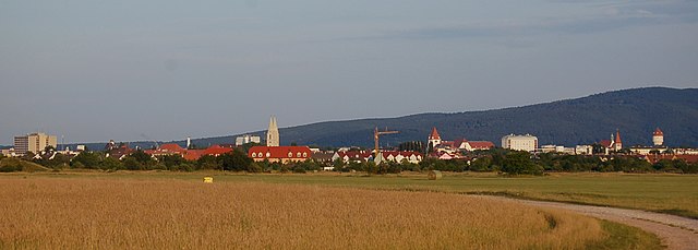
Lichtenwörth (Lichtenwörth)
- municipality in Austria
Lichtenwörth is a charming municipality located in Austria, not far from the city of Wiener Neustadt. The surrounding landscape offers a variety of hiking trails suitable for different skill levels, making it a great destination for both beginners and experienced hikers.
Hiking Trails
-
Local Trails: There are several marked trails around Lichtenwörth that meander through picturesque landscapes, including forests, meadows, and alongside rivers. Many of these trails provide opportunities for nature observation and photography.
-
The Leitha Mountains: A bit further afield, the Leitha Mountain range presents more challenging hikes with elevated views of the surrounding areas. These trails can vary in difficulty, but they offer stunning panoramas, especially from higher vantage points.
-
The Burgenland Trail: For those looking for a longer trek, you can connect to parts of the Burgenland Trail, which stretches across various regions of Burgenland and provides scenic views and cultural experiences along the way.
Preparation Tips
- Weather Awareness: Always check the weather forecast before heading out. Conditions can change rapidly in mountainous areas.
- Gear Up: Wear appropriate hiking boots and clothing. Layers are recommended as temperatures can vary.
- Hydration and Snacks: Carry enough water and energy-rich snacks to keep you energized throughout your hike.
- Navigation Tools: Consider taking a map or using a hiking app on your phone for trail navigation.
Local Attractions
After your hike, you might enjoy exploring the local culture, trying traditional Austrian cuisine, or relaxing in a nearby café.
Be sure to check local regulations regarding hiking in natural parks or private lands, and enjoy your outdoor adventure in Lichtenwörth!
- Country:

- Local Dialing Code: 02622
- Licence Plate Code: WB
- Coordinates: 47° 49' 55" N, 16° 17' 44" E


- GPS tracks (wikiloc): [Link]
- AboveSeaLevel: 254 м m
- Area: 22.91 sq km
- Population: 2727
- Web site: http://www.lichtenwoerth.at
- Wikipedia en: wiki(en)
- Wikipedia: wiki(de)
- Wikidata storage: Wikidata: Q263044
- Wikipedia Commons Category: [Link]
- Freebase ID: [/m/04l8xh]
- GeoNames ID: Alt: [7873055]
- VIAF ID: Alt: [123287094]
- OSM relation ID: [110483]
- GND ID: Alt: [4800143-0]
- archINFORM location ID: [10308]
- Library of Congress authority ID: Alt: [n91001136]
- MusicBrainz area ID: [134f9dd0-d280-4a36-b8db-675865cd3ac0]
- Austrian municipality key: [32318]
- Digital Atlas of the Roman Empire ID: [42752]
Shares border with regions:


Wiener Neustadt
- city in Lower Austria, Austria
Wiener Neustadt, located in Lower Austria, offers several hiking opportunities for outdoor enthusiasts. The region is characterized by a mix of stunning natural landscapes, historical sites, and diverse trails suitable for various skill levels. Here are some highlights and tips for hiking in Wiener Neustadt:...
- Country:

- Postal Code: 2700
- Local Dialing Code: 02622
- Licence Plate Code: WN
- Coordinates: 47° 49' 0" N, 16° 15' 0" E


- GPS tracks (wikiloc): [Link]
- AboveSeaLevel: 265 м m
- Area: 60.94 sq km
- Population: 44461
- Web site: [Link]

Zillingdorf
- municipality in Austria
Zillingdorf, located in Austria, offers a variety of hiking opportunities that cater to different skill levels. The region is characterized by its picturesque landscapes, rolling hills, and beautiful views, making it a great destination for nature enthusiasts and hikers....
- Country:

- Local Dialing Code: 02622
- Licence Plate Code: WB
- Coordinates: 47° 51' 0" N, 16° 20' 0" E


- GPS tracks (wikiloc): [Link]
- AboveSeaLevel: 241 м m
- Area: 15.34 sq km
- Population: 2030
- Web site: [Link]

Neudörfl
- municipality in Austria
Neudörfl is a charming village located in the Burgenland region of Austria. Surrounded by natural beauty and a tranquil countryside, it offers various opportunities for hiking enthusiasts. Here are some key points to consider when hiking in and around Neudörfl:...
- Country:

- Postal Code: 7201
- Local Dialing Code: 02622
- Licence Plate Code: MA
- Coordinates: 47° 47' 52" N, 16° 17' 48" E


- GPS tracks (wikiloc): [Link]
- AboveSeaLevel: 273 м m
- Area: 9.01 sq km
- Population: 4564
- Web site: [Link]


Pöttsching
- municipality in Austria
Pöttsching, located in Austria's Lower Austria region, is surrounded by beautiful landscapes that are suitable for hiking enthusiasts. The area features gentle hills, woodlands, and scenic views, making it an excellent destination for outdoor activities....
- Country:

- Postal Code: 7033
- Local Dialing Code: 0664
- Licence Plate Code: MA
- Coordinates: 47° 48' 24" N, 16° 22' 10" E


- GPS tracks (wikiloc): [Link]
- AboveSeaLevel: 218 м m
- Area: 24.6 sq km
- Population: 2950
- Web site: [Link]

Eggendorf
- municipality in Austria
Eggendorf, located in Lower Austria, is surrounded by picturesque landscapes that offer a range of hiking opportunities. The region is characterized by its rolling hills, lush forests, and scenic views, making it an excellent destination for outdoor enthusiasts....
- Country:

- Local Dialing Code: 02622
- Licence Plate Code: WB
- Coordinates: 47° 51' 24" N, 16° 19' 40" E


- GPS tracks (wikiloc): [Link]
- AboveSeaLevel: 241 м m
- Area: 20.59 sq km
- Population: 4794
- Web site: [Link]
