Wilhelmsburg (Wilhelmsburg)
- municipality in Austria
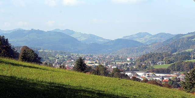
 Hiking in Wilhelmsburg
Wilhelmsburg, a municipality in the district of Sankt Pölten-Land in Lower Austria, offers a charming backdrop for hiking enthusiasts. Nestled near the Traisen River and surrounded by beautiful countryside, it presents a mix of scenic trails and rural landscapes that cater to hikers of all levels.
Hiking Trails and Routes:
-
Local Trails: There are several well-marked local hiking trails that meander through the fields and forests of the region. These often offer breathtaking views of the surrounding hills and valleys.
-
Traisen River Trails: Exploring the trails along the Traisen River can be a peaceful experience. The riverside environment is perfect for those who appreciate a combination of nature and water features.
-
Nearby Natural Reserves: The nearby Oebisfelder Wald or other forested areas offer opportunities for more extended hikes. You can explore various paths that take you deeper into nature, providing a chance to observe local wildlife.
-
Historical Routes: Some trails might also lead to historical sites, providing a glimpse into the region's rich history and architecture.
Hiking Tips:
- Seasonal Considerations: Spring and early autumn are ideal for hiking in this area, as they allow you to enjoy pleasant weather and vibrant natural colors.
- Trail Maps: It's advisable to carry a detailed map or download a hiking app to navigate the trails effectively.
- Local Regulations: Familiarize yourself with local regulations regarding trail use and wildlife conservation to ensure a responsible hiking experience.
- Safety First: Ensure you have appropriate hiking gear, plenty of water, and snacks to maintain your energy levels during your hikes.
Conclusion:
Wilhelmsburg offers a peaceful escape into nature with its variety of hiking trails, making it a delightful destination for a hiking trip in Austria. Whether you're looking for a leisurely stroll or a more challenging hike, you'll find something to suit your preferences in this picturesque area.
- Country:

- Postal Code: 3150
- Local Dialing Code: 0 27 46
- Licence Plate Code: PL
- Coordinates: 48° 6' 39" N, 15° 36' 36" E


- GPS tracks (wikiloc): [Link]
- AboveSeaLevel: 321 м m
- Area: 45.76 sq km
- Population: 6557
- Web site: http://www.wilhelmsburg.gv.at/
- Wikipedia en: wiki(en)
- Wikipedia: wiki(de)
- Wikidata storage: Wikidata: Q665268
- Wikipedia Commons Category: [Link]
- Freebase ID: [/m/03grrzm]
- GeoNames ID: Alt: [7871897]
- GND ID: Alt: [4343326-1]
- archINFORM location ID: [10006]
- MusicBrainz area ID: [7906b210-4974-40c6-bfd9-a113f0e75b5f]
- Austrian municipality key: [31947]
Shares border with regions:

Ober-Grafendorf
- municipality in Austria
Hiking in Ober-Grafendorf
Ober-Grafendorf, a charming municipality located in the Lower Austria region, offers a variety of hiking opportunities for outdoor enthusiasts. The area is characterized by its picturesque landscapes, rolling hills, and lush forests, making it an ideal destination for both casual walkers and avid hikers....
- Country:
- Postal Code: 3200
- Local Dialing Code: 02747
- Licence Plate Code: PL
- Coordinates: 48° 9' 3" N, 15° 32' 39" E
- GPS tracks (wikiloc): [Link]
- AboveSeaLevel: 280 м m
- Area: 24.56 sq km
- Population: 4544
- Web site: [Link]
Weinburg
- municipality in Austria
Hiking in Weinburg
Weinburg, a picturesque area often associated with beautiful landscapes and scenic trails, offers a delightful experience for hikers of all levels. While I don't have specific details about a specific "Weinburg," if you are referring to general hiking in a region known for its vineyards and wine culture, here are some pointers that might help you plan your hike:...
- Country:
- Postal Code: 3205
- Local Dialing Code: 02747
- Licence Plate Code: PL
- Coordinates: 48° 6' 0" N, 15° 32' 0" E
- GPS tracks (wikiloc): [Link]
- AboveSeaLevel: 321 м m
- Area: 10.36 sq km
- Population: 1337
- Web site: [Link]
Pyhra
- municipality in Austria
Hiking in Pyhra
Pyhra is a small town in Austria, located in the lower part of the country, close to the scenic landscapes of the Alps. While it may not be as widely known as some of the larger tourist destinations in Austria, it offers a wealth of opportunities for hiking enthusiasts....
- Country:
- Postal Code: 3143
- Local Dialing Code: 02745
- Licence Plate Code: PL
- Coordinates: 48° 9' 0" N, 15° 41' 0" E
- GPS tracks (wikiloc): [Link]
- AboveSeaLevel: 298 м m
- Area: 66.76 sq km
- Population: 3553
- Web site: [Link]
Hofstetten-Grünau
- municipality in Austria
Hiking in Hofstetten-Grünau
Hofstetten-Grünau is a picturesque area located in the Emmental region of Switzerland. It offers a variety of hiking opportunities suitable for different levels of experience and fitness. Here are some key highlights for hiking in Hofstetten-Grünau:...
- Country:
- Postal Code: 3202
- Local Dialing Code: 02723
- Licence Plate Code: PL
- Coordinates: 48° 5' 0" N, 15° 30' 0" E
- GPS tracks (wikiloc): [Link]
- AboveSeaLevel: 317 м m
- Area: 35.93 sq km
- Population: 2693
- Web site: [Link]
Sankt Veit an der Gölsen
- municipality in Austria
Hiking in Sankt Veit an der Gölsen
Sankt Veit an der Gölsen, located in Lower Austria, offers a variety of hiking opportunities set against beautiful landscapes, including rolling hills, forests, and picturesque views. Here are some key points for hiking in this area:...
- Country:
- Postal Code: 3161
- Local Dialing Code: 02763
- Licence Plate Code: LF
- Coordinates: 48° 2' 0" N, 15° 40' 0" E
- GPS tracks (wikiloc): [Link]
- AboveSeaLevel: 369 м m
- Area: 78.14 sq km
- Population: 3915
- Web site: [Link]
Eschenau
- municipality in Austria
Hiking in Eschenau
Eschenau, located in the scenic region of Bavaria, Germany, offers several hiking opportunities that highlight the area's natural beauty and cultural heritage....
- Country:
- Postal Code: 3153
- Local Dialing Code: 02762
- Licence Plate Code: LF
- Coordinates: 48° 2' 0" N, 15° 34' 0" E
- GPS tracks (wikiloc): [Link]
- AboveSeaLevel: 406 м m
- Area: 24.71 sq km
- Population: 1306
- Web site: [Link]

St. Pölten
- town in Austria, capital of Lower Austria
Hiking in St. Pölten
Sankt Pölten, the capital of Lower Austria, offers a variety of hiking opportunities that cater to different skill levels and preferences. Here are some noteworthy aspects of hiking in and around Sankt Pölten:...
- Country:
- Postal Code: 3100
- Local Dialing Code: 02742
- Licence Plate Code: P
- Coordinates: 48° 12' 0" N, 15° 37' 0" E
- GPS tracks (wikiloc): [Link]
- AboveSeaLevel: 267 м m
- Area: 108.52 sq km
- Population: 53445
- Web site: [Link]