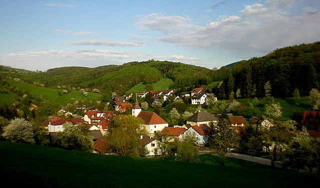
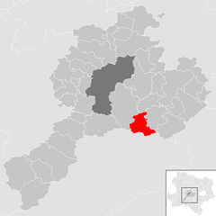
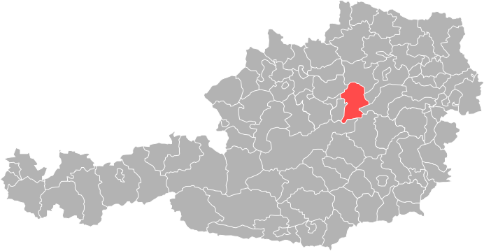
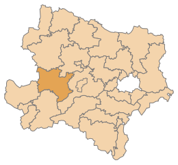
Sankt Pölten-Land District (Bezirk Sankt Pölten-Land)

- district of Austria
 Hiking in Sankt Pölten-Land District
Sankt Pölten-Land District, located in the Lower Austria region of Austria, is a scenic area that offers numerous hiking opportunities amidst beautiful landscapes, cultural heritage, and nature reserves. Here are some highlights and tips for hiking in this district:
Hiking Trails:
-
Wienerwald (Vienna Woods): The Wienerwald offers various well-marked trails that provide a mix of forested areas, meadows, and panoramic views. These are suitable for both casual hikers and those looking for more challenging routes.
-
Waldviertel Region: This area features stunning natural landscapes with unique rock formations and picturesque valleys. Trails often connect charming villages, allowing you to enjoy local culture along the way.
-
Naturpark Ötscher-Tormäuer: This nature park, while partially in the neighboring district, is easily accessible from Sankt Pölten-Land. It offers a range of trails with breathtaking views of the Ötscher mountain and the Tormäuer gorge.
Highlights:
- Scenic Views: Many trails in the district offer stunning views of the surrounding hills and valleys, especially during the fall when the foliage is vibrant.
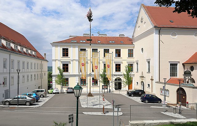
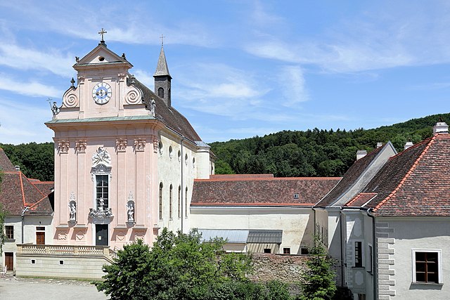
- Historical Sites: You can combine hiking with visits to historical sites, such as old castles and traditional villages.
- Flora and Fauna: The region is rich in biodiversity, so keep an eye out for various plant species and wildlife during your hikes.
Practical Tips:
- Trail Markings: Most trails are well-marked with signs indicating the route, distance, and estimated hiking time. Always carry a map or a GPS device for navigation.
- Preparation: Depending on the season, weather conditions can change rapidly. Dress in layers, wear sturdy footwear, and pack sufficient water and snacks.
- Respect Nature: Follow the Leave No Trace principles. Stick to the trails, carry out all trash, and respect wildlife and vegetation.
Accessibility:
The district is well-connected by public transportation from larger cities like Vienna, making it easy for hikers to access these beautiful trails. Local tourist information centers can provide additional maps and guidance.
Whether you are looking for a peaceful day hike or a multi-day trekking adventure, Sankt Pölten-Land District offers a diverse range of trails that cater to all skill levels and interests. Happy hiking!
- Country:

- Licence Plate Code: PL
- Coordinates: 48° 10' 59" N, 15° 40' 1" E


- GPS tracks (wikiloc): [Link]
- AboveSeaLevel: 313 м m
- Area: 1121.61 sq km
- Web site: http://www.noel.gv.at/service/bh/nk/bhnk.htm
- Wikipedia en: wiki(en)
- Wikipedia: wiki(de)
- Wikidata storage: Wikidata: Q694393
- Wikipedia Commons Category: [Link]
- Freebase ID: [/m/0flbqp]
- GeoNames ID: Alt: [2766428]
- VIAF ID: Alt: [141896992]
- GND ID: Alt: [4802307-3]
- archINFORM location ID: [14639]
- Library of Congress authority ID: Alt: [n80155548]
Includes regions:
Haunoldstein
- municipality in Austria
Hiking in Haunoldstein
Haunoldstein, located in Austria, is a beautiful area that offers a range of hiking opportunities suitable for various skill levels. The region is known for its picturesque landscapes, which include rolling hills, dense forests, and stunning views of the surrounding mountains....
- Country:
- Postal Code: 3384
- Local Dialing Code: 02749
- Licence Plate Code: PL
- Coordinates: 48° 11' 42" N, 15° 27' 24" E
- GPS tracks (wikiloc): [Link]
- AboveSeaLevel: 250 м m
- Area: 9.89 sq km
- Population: 1160
- Web site: [Link]
Frankenfels
- municipality in Austria
Hiking in Frankenfels
Frankenfels is a picturesque village located in the Lower Austria region, nestled in the foothills of the Ötscher mountain range. This area is known for its stunning natural beauty and offers a variety of hiking opportunities for outdoor enthusiasts of all skill levels....
- Country:
- Postal Code: 3213
- Local Dialing Code: 02725
- Licence Plate Code: PL
- Coordinates: 47° 58' 0" N, 15° 19' 0" E
- GPS tracks (wikiloc): [Link]
- AboveSeaLevel: 464 м m
- Area: 56.11 sq km
- Population: 1975
- Web site: [Link]

Sankt Margarethen an der Sierning
- municipality in Austria
Hiking in Sankt Margarethen an der Sierning
Sankt Margarethen an der Sierning is a charming village located in the Upper Austria region, surrounded by picturesque landscapes that offer great opportunities for hiking. The area is characterized by rolling hills, lush forests, and scenic views, making it a perfect destination for outdoor enthusiasts....
- Country:
- Postal Code: 3231
- Local Dialing Code: 02747
- Licence Plate Code: PL
- Coordinates: 48° 9' 32" N, 15° 29' 31" E
- GPS tracks (wikiloc): [Link]
- AboveSeaLevel: 261 м m
- Area: 14.56 sq km
- Population: 1013
- Web site: [Link]

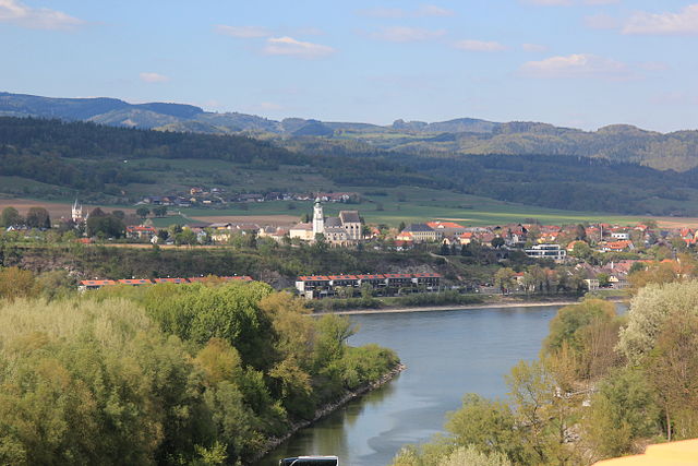
Traismauer
- municipality in Austria
Hiking in Traismauer
Traismauer is a charming town in Lower Austria that offers a variety of hiking opportunities, especially for those looking to explore the scenic beauty of the region. Here are some highlights for hiking in and around Traismauer:...
- Country:
- Postal Code: 3133
- Licence Plate Code: PL
- Coordinates: 48° 20' 0" N, 15° 43' 59" E
- GPS tracks (wikiloc): [Link]
- AboveSeaLevel: 197 м m
- Area: 43.14 sq km
- Population: 6224
- Web site: [Link]

Altlengbach
- municipality in Austria
Hiking in Altlengbach
Altlengbach is a picturesque region located in Lower Austria, known for its stunning natural beauty and outdoor recreational opportunities. Hiking in Altlengbach offers a variety of trails that cater to different skill levels, making it an excellent destination for both novice and experienced hikers....
- Country:
- Postal Code: 3033
- Local Dialing Code: 02774
- Licence Plate Code: PL
- Coordinates: 48° 9' 0" N, 15° 55' 0" E
- GPS tracks (wikiloc): [Link]
- AboveSeaLevel: 302 м m
- Area: 35.58 sq km
- Population: 2927
- Web site: [Link]
Nußdorf ob der Traisen
- municipality in Austria
Hiking in Nußdorf ob der Traisen
Nußdorf ob der Traisen is a charming village located in the Lower Austria region of Austria, surrounded by picturesque landscapes that are perfect for hiking enthusiasts. The area offers a variety of hiking trails that cater to different skill levels, making it a wonderful destination for both novice and experienced hikers....
- Country:
- Postal Code: 3134
- Local Dialing Code: 02783
- Licence Plate Code: PL
- Coordinates: 48° 21' 12" N, 15° 41' 42" E
- GPS tracks (wikiloc): [Link]
- AboveSeaLevel: 249 м m
- Area: 15.43 sq km
- Population: 1758
- Web site: [Link]
Weißenkirchen an der Perschling
- municipality in Austria
Hiking in Weißenkirchen an der Perschling
Weißenkirchen an der Perschling is a picturesque village located in the Lower Austria region of Austria. Surrounded by beautiful landscapes, rolling hills, and vineyards, it offers various hiking opportunities that cater to different experience levels....
- Country:
- Postal Code: 3142
- Local Dialing Code: 02784
- Licence Plate Code: PL
- Coordinates: 48° 16' 0" N, 15° 46' 0" E
- GPS tracks (wikiloc): [Link]
- AboveSeaLevel: 220 м m
- Area: 23.8 sq km
- Population: 1395
- Web site: [Link]

Purkersdorf
- municipality in Austria
Hiking in Purkersdorf
Purkersdorf, located just outside of Vienna, Austria, is an excellent destination for hiking enthusiasts. The area is known for its beautiful natural landscapes, rolling hills, and proximity to the Wienerwald (Vienna Woods), which offers a diverse network of trails. Here are some key highlights and tips for hiking in Purkersdorf:...
- Country:
- Postal Code: 3002
- Local Dialing Code: 02231
- Licence Plate Code: WU
- Coordinates: 48° 12' 33" N, 16° 10' 45" E
- GPS tracks (wikiloc): [Link]
- AboveSeaLevel: 248 м m
- Area: 30.26 sq km
- Population: 9701
- Web site: [Link]
Kirchberg an der Pielach
- municipality in Austria
Hiking in Kirchberg an der Pielach
Kirchberg an der Pielach, located in the picturesque Lower Austria region, offers an array of hiking opportunities for outdoor enthusiasts. The area is known for its beautiful landscapes, rolling hills, and the serene Pielach River, which provides a stunning backdrop for various hiking trails....
- Country:
- Postal Code: 3204
- Local Dialing Code: 02722
- Licence Plate Code: PL
- Coordinates: 48° 1' 0" N, 15° 26' 0" E
- GPS tracks (wikiloc): [Link]
- AboveSeaLevel: 371 м m
- Area: 63.52 sq km
- Population: 3225
- Web site: [Link]

Gablitz
- municipality in Austria
Hiking in Gablitz
Gablitz, located in Austria's Lower Austria region, is surrounded by beautiful landscapes, making it an excellent destination for hiking enthusiasts. The area features a mix of forests, hills, and scenic views, providing a variety of trails suitable for different skill levels....
- Country:
- Postal Code: 3003
- Local Dialing Code: 02231
- Licence Plate Code: WU
- Coordinates: 48° 13' 33" N, 16° 8' 48" E
- GPS tracks (wikiloc): [Link]
- AboveSeaLevel: 284 м m
- Area: 18.14 sq km
- Population: 4968
- Web site: [Link]

Wilhelmsburg
- municipality in Austria
Hiking in Wilhelmsburg
Wilhelmsburg, a municipality in the district of Sankt Pölten-Land in Lower Austria, offers a charming backdrop for hiking enthusiasts. Nestled near the Traisen River and surrounded by beautiful countryside, it presents a mix of scenic trails and rural landscapes that cater to hikers of all levels....
- Country:
- Postal Code: 3150
- Local Dialing Code: 0 27 46
- Licence Plate Code: PL
- Coordinates: 48° 6' 39" N, 15° 36' 36" E
- GPS tracks (wikiloc): [Link]
- AboveSeaLevel: 321 м m
- Area: 45.76 sq km
- Population: 6557
- Web site: [Link]

Ober-Grafendorf
- municipality in Austria
Hiking in Ober-Grafendorf
Ober-Grafendorf, a charming municipality located in the Lower Austria region, offers a variety of hiking opportunities for outdoor enthusiasts. The area is characterized by its picturesque landscapes, rolling hills, and lush forests, making it an ideal destination for both casual walkers and avid hikers....
- Country:
- Postal Code: 3200
- Local Dialing Code: 02747
- Licence Plate Code: PL
- Coordinates: 48° 9' 3" N, 15° 32' 39" E
- GPS tracks (wikiloc): [Link]
- AboveSeaLevel: 280 м m
- Area: 24.56 sq km
- Population: 4544
- Web site: [Link]

Asperhofen
- municipality in Austria
Hiking in Asperhofen
Asperhofen, a small village located in Austria, offers a variety of scenic hiking opportunities that showcase the beauty of the surrounding countryside. Here are some aspects to consider when planning a hiking trip in Asperhofen:...
- Country:
- Postal Code: 3041
- Local Dialing Code: 02772
- Licence Plate Code: PL
- Coordinates: 48° 15' 0" N, 15° 55' 0" E
- GPS tracks (wikiloc): [Link]
- AboveSeaLevel: 212 м m
- Area: 28.85 sq km
- Population: 2206
- Web site: [Link]
Weinburg
- municipality in Austria
Hiking in Weinburg
Weinburg, a picturesque area often associated with beautiful landscapes and scenic trails, offers a delightful experience for hikers of all levels. While I don't have specific details about a specific "Weinburg," if you are referring to general hiking in a region known for its vineyards and wine culture, here are some pointers that might help you plan your hike:...
- Country:
- Postal Code: 3205
- Local Dialing Code: 02747
- Licence Plate Code: PL
- Coordinates: 48° 6' 0" N, 15° 32' 0" E
- GPS tracks (wikiloc): [Link]
- AboveSeaLevel: 321 м m
- Area: 10.36 sq km
- Population: 1337
- Web site: [Link]

Pressbaum
- municipality in Austria
Hiking in Pressbaum
Pressbaum is a charming town located in Lower Austria, nestled in the Vienna Woods (Wienerwald). This area is a fantastic destination for hiking enthusiasts, offering a variety of trails that cater to different skill levels, from easy walks to more challenging hikes....
- Country:
- Postal Code: 3021
- Local Dialing Code: 02233
- Licence Plate Code: WU
- Coordinates: 48° 11' 0" N, 16° 4' 57" E
- GPS tracks (wikiloc): [Link]
- AboveSeaLevel: 315 м m
- Area: 58.87 sq km
- Population: 7559
- Web site: [Link]

Rabenstein an der Pielach
- municipality in Austria
Hiking in Rabenstein an der Pielach
Rabenstein an der Pielach is a charming village located in Lower Austria, surrounded by beautiful natural landscapes, making it an excellent destination for hiking enthusiasts. The area features various trails that cater to different skill levels, ranging from leisurely walks to more challenging hikes....
- Country:
- Postal Code: 3203
- Local Dialing Code: 02723
- Licence Plate Code: PL
- Coordinates: 48° 2' 0" N, 15° 28' 0" E
- GPS tracks (wikiloc): [Link]
- AboveSeaLevel: 344 м m
- Area: 36.25 sq km
- Population: 2560
- Web site: [Link]
Tullnerbach
- municipality in Austria
Hiking in Tullnerbach
Tullnerbach, located in Austria near Vienna, is a lovely destination for hiking enthusiasts. This area is characterized by beautiful landscapes, rolling hills, and lush forests, making it a great spot for various hiking trails suitable for different skill levels....
- Country:
- Local Dialing Code: 02233
- Licence Plate Code: WU
- Coordinates: 48° 12' 0" N, 16° 6' 0" E
- GPS tracks (wikiloc): [Link]
- AboveSeaLevel: 350 м m
- Area: 20.24 sq km
- Population: 2782
- Web site: [Link]

Herzogenburg
- municipality in Austria
Hiking in Herzogenburg
Herzogenburg, located in the Lower Austria region, is a charming town that offers several opportunities for hiking and enjoying the natural beauty of the surrounding areas. Here are some key features and recommendations for hiking in and around Herzogenburg:...
- Country:
- Postal Code: 3130
- Local Dialing Code: 02782
- Licence Plate Code: PL
- Coordinates: 48° 17' 0" N, 15° 41' 0" E
- GPS tracks (wikiloc): [Link]
- AboveSeaLevel: 229 м m
- Area: 46.16 sq km
- Population: 7771
- Web site: [Link]
Wolfsgraben
- municipality in Austria
Hiking in Wolfsgraben
Wolfsgraben is a picturesque area that offers a range of hiking opportunities for both beginners and experienced hikers. Located in the region near Vienna, Austria, it features beautiful landscapes, lush forests, and scenic trails that allow hikers to connect with nature....
- Country:
- Local Dialing Code: 02233
- Licence Plate Code: WU
- Coordinates: 48° 9' 31" N, 16° 7' 5" E
- GPS tracks (wikiloc): [Link]
- AboveSeaLevel: 323 м m
- Area: 17.44 sq km
- Population: 1700
- Web site: [Link]
Pyhra
- municipality in Austria
Hiking in Pyhra
Pyhra is a small town in Austria, located in the lower part of the country, close to the scenic landscapes of the Alps. While it may not be as widely known as some of the larger tourist destinations in Austria, it offers a wealth of opportunities for hiking enthusiasts....
- Country:
- Postal Code: 3143
- Local Dialing Code: 02745
- Licence Plate Code: PL
- Coordinates: 48° 9' 0" N, 15° 41' 0" E
- GPS tracks (wikiloc): [Link]
- AboveSeaLevel: 298 м m
- Area: 66.76 sq km
- Population: 3553
- Web site: [Link]
Markersdorf-Haindorf
- municipality in Austria
Hiking in Markersdorf-Haindorf
Markersdorf-Haindorf is a picturesque area located in Austria, known for its beautiful landscapes and serene hiking trails. Hiking in this region offers a great opportunity to experience nature while enjoying the cultural heritage of the area. Here are some key points to consider when hiking in Markersdorf-Haindorf:...
- Country:
- Postal Code: 3385
- Local Dialing Code: 02749
- Licence Plate Code: PL
- Coordinates: 48° 11' 0" N, 15° 30' 0" E
- GPS tracks (wikiloc): [Link]
- AboveSeaLevel: 252 м m
- Area: 16.67 sq km
- Population: 2080
- Web site: [Link]
Stössing
- municipality in Austria
Hiking in Stössing
Stössing, a quaint village in the Lower Austria region, offers a variety of hiking opportunities that are perfect for both casual walkers and more experienced trekkers. The surrounding landscapes consist of rolling hills, lush forests, and picturesque views, making it an ideal destination for nature lovers....
- Country:
- Postal Code: 3073
- Local Dialing Code: 02744
- Licence Plate Code: PL
- Coordinates: 48° 7' 0" N, 15° 49' 0" E
- GPS tracks (wikiloc): [Link]
- AboveSeaLevel: 344 м m
- Area: 27.47 sq km
- Population: 838
- Web site: [Link]
Schwarzenbach an der Pielach
- municipality in Austria
Hiking in Schwarzenbach an der Pielach
Schwarzenbach an der Pielach is a charming village located in Lower Austria, known for its picturesque landscapes and the serenity of the Pielach River. The surrounding region offers a range of hiking opportunities, perfect for both beginners and experienced hikers. Here are some highlights and tips for hiking in this area:...
- Country:
- Postal Code: 3212
- Local Dialing Code: 02724
- Licence Plate Code: PL
- Coordinates: 47° 56' 0" N, 15° 23' 0" E
- GPS tracks (wikiloc): [Link]
- AboveSeaLevel: 510 м m
- Area: 45.45 sq km
- Population: 369
- Web site: [Link]

Wölbling
- municipality in Austria
Hiking in Wölbling
Wölbling, located in Austria, is a charming area ideal for hiking enthusiasts. The region's picturesque landscapes, featuring rolling hills, lush forests, and scenic views, make it an attractive destination for outdoor activities....
- Country:
- Postal Code: 3124
- Local Dialing Code: 02786
- Licence Plate Code: PL
- Coordinates: 48° 19' 0" N, 15° 35' 0" E
- GPS tracks (wikiloc): [Link]
- AboveSeaLevel: 342 м m
- Area: 32.37 sq km
- Population: 2571
- Web site: [Link]

Obritzberg-Rust
- municipality in Austria
Hiking in Obritzberg-Rust
Obritzberg-Rust is a picturesque area located in Austria, known for its beautiful landscapes and outdoor activities, including hiking. While specific trails can vary, the region typically offers a variety of hiking options ranging from easy walks to more challenging routes. Here are some general highlights about hiking in Obritzberg-Rust:...
- Country:
- Postal Code: 3123
- Licence Plate Code: PL
- Coordinates: 48° 17' 0" N, 15° 36' 0" E
- GPS tracks (wikiloc): [Link]
- AboveSeaLevel: 366 м m
- Area: 41.48 sq km
- Population: 2342
- Web site: [Link]

Kirchstetten
- municipality in Austria
Hiking in Kirchstetten
Kirchstetten, located in Lower Austria, is a beautiful area for hiking enthusiasts. The region boasts a variety of trails that range from easy walks suitable for families to more challenging hikes for experienced trekkers. Here are some highlights about hiking in Kirchstetten:...
- Country:
- Postal Code: 3062
- Local Dialing Code: 02743
- Licence Plate Code: PL
- Coordinates: 48° 11' 0" N, 15° 49' 0" E
- GPS tracks (wikiloc): [Link]
- AboveSeaLevel: 270 м m
- Area: 17.76 sq km
- Population: 2189
- Web site: [Link]
Hofstetten-Grünau
- municipality in Austria
Hiking in Hofstetten-Grünau
Hofstetten-Grünau is a picturesque area located in the Emmental region of Switzerland. It offers a variety of hiking opportunities suitable for different levels of experience and fitness. Here are some key highlights for hiking in Hofstetten-Grünau:...
- Country:
- Postal Code: 3202
- Local Dialing Code: 02723
- Licence Plate Code: PL
- Coordinates: 48° 5' 0" N, 15° 30' 0" E
- GPS tracks (wikiloc): [Link]
- AboveSeaLevel: 317 м m
- Area: 35.93 sq km
- Population: 2693
- Web site: [Link]
Loich
- municipality in Austria
Hiking in Loich
Loich is a picturesque village located in the Lower Austria region of Austria, surrounded by stunning natural landscapes perfect for hiking. The area is characterized by its rolling hills, lush forests, and impressive mountain views, making it a fantastic destination for both novice and experienced hikers....
- Country:
- Postal Code: 3211
- Local Dialing Code: 02722
- Licence Plate Code: PL
- Coordinates: 47° 59' 0" N, 15° 24' 0" E
- GPS tracks (wikiloc): [Link]
- AboveSeaLevel: 449 м m
- Area: 24.51 sq km
- Population: 603
- Web site: [Link]
Kapelln
- place in Lower Austria, Austria
Hiking in Kapelln
Kapelln is a charming village located in the Lower Austria region of Austria. While it may not be as well-known as some tourist hotspots, it offers scenic landscapes, peaceful surroundings, and various trails that are perfect for hiking enthusiasts. Here are some highlights and tips for hiking in and around Kapelln:...
- Country:
- Postal Code: 3141
- Local Dialing Code: 02784
- Licence Plate Code: PL
- Coordinates: 48° 15' 0" N, 15° 45' 0" E
- GPS tracks (wikiloc): [Link]
- AboveSeaLevel: 226 м m
- Area: 20.18 sq km
- Population: 1381
- Web site: [Link]
Hafnerbach
- municipality in Austria
Hiking in Hafnerbach
Hafnerbach is a small village located in the region of Lower Austria, not far from the picturesque countryside and natural landscapes that the area offers. If you're considering hiking in and around Hafnerbach, you'll have the opportunity to experience beautiful rolling hills, lush forests, and scenic views....
- Country:
- Postal Code: 3386
- Local Dialing Code: 02749
- Licence Plate Code: PL
- Coordinates: 48° 13' 0" N, 15° 29' 0" E
- GPS tracks (wikiloc): [Link]
- AboveSeaLevel: 266 м m
- Area: 29.23 sq km
- Population: 1672
- Web site: [Link]

Maria Anzbach
- municipality in Austria
Hiking in Maria Anzbach
Maria Anzbach, a small municipality in Lower Austria, offers a variety of hiking opportunities for outdoor enthusiasts. Located near the Vienna Woods, it provides a picturesque setting with rolling hills, forests, and scenic views, making it an ideal destination for hikers of all levels....
- Country:
- Postal Code: 3034
- Local Dialing Code: 02772
- Licence Plate Code: PL
- Coordinates: 48° 11' 0" N, 15° 56' 0" E
- GPS tracks (wikiloc): [Link]
- AboveSeaLevel: 245 м m
- Area: 18.19 sq km
- Population: 3055
- Web site: [Link]
Neustift-Innermanzing
- municipality in Austria
Hiking in Neustift-Innermanzing
Neustift-Innermanzing, located in Austria, is a charming area that offers a variety of hiking opportunities with beautiful landscapes and scenic views. Here are some key highlights to consider when hiking in this region:...
- Country:
- Postal Code: 3052
- Local Dialing Code: 02774
- Licence Plate Code: PL
- Coordinates: 48° 7' 0" N, 15° 54' 0" E
- GPS tracks (wikiloc): [Link]
- AboveSeaLevel: 298 м m
- Area: 14.9 sq km
- Population: 1543
- Web site: [Link]
Karlstetten
- municipality in Austria
Hiking in Karlstetten
Karlstetten is a charming village located in Lower Austria, known for its scenic landscapes and hiking opportunities. The area is characterized by rolling hills, forests, and picturesque views, making it an excellent destination for outdoor enthusiasts. Here are some highlights for hiking in Karlstetten:...
- Country:
- Postal Code: 3121
- Local Dialing Code: 02741
- Licence Plate Code: PL
- Coordinates: 48° 15' 29" N, 15° 33' 57" E
- GPS tracks (wikiloc): [Link]
- AboveSeaLevel: 375 м m
- Area: 28.26 sq km
- Population: 2159
- Web site: [Link]

Gerersdorf
- municipality in Austria
Hiking in Gerersdorf
Gerersdorf, located in Austria, is surrounded by beautiful landscapes that are perfect for hiking enthusiasts. The region typically features rolling hills, vineyards, and scenic views of the surrounding countryside. While specific trails in Gerersdorf may not be widely documented, there are several general aspects you can explore:...
- Country:
- Postal Code: 3385
- Local Dialing Code: 02749
- Licence Plate Code: PL
- Coordinates: 48° 11' 57" N, 15° 33' 18" E
- GPS tracks (wikiloc): [Link]
- AboveSeaLevel: 289 м m
- Area: 13.67 sq km
- Population: 974
- Web site: [Link]
Kasten bei Böheimkirchen
- municipality in Austria
Hiking in Kasten bei Böheimkirchen
Kasten bei Böheimkirchen is a charming village located in Lower Austria, surrounded by beautiful landscapes that are perfect for hiking enthusiasts. The area features a combination of picturesque countryside, rolling hills, and forests that make for a variety of hiking trails suitable for different skill levels....
- Country:
- Postal Code: 3072
- Local Dialing Code: 02744
- Licence Plate Code: PL
- Coordinates: 48° 9' 0" N, 15° 47' 0" E
- GPS tracks (wikiloc): [Link]
- AboveSeaLevel: 290 м m
- Area: 20.51 sq km
- Population: 1409
- Web site: [Link]

Statzendorf
- municipality in Austria
Hiking in Statzendorf
Statzendorf, a small village located in Austria, is situated in a picturesque area that offers several hiking opportunities. The natural landscapes around Statzendorf are characterized by beautiful hills, forests, and charming rural vistas, making it an attractive destination for both casual walkers and more experienced hikers....
- Country:
- Postal Code: 3125
- Local Dialing Code: 02786
- Licence Plate Code: PL
- Coordinates: 48° 18' 29" N, 15° 38' 27" E
- GPS tracks (wikiloc): [Link]
- AboveSeaLevel: 295 м m
- Area: 12.44 sq km
- Population: 1362
- Web site: [Link]
Neidling
- municipality in Austria
Hiking in Neidling
Neidling, a small municipality in Austria, is a great spot for hiking enthusiasts looking for beautiful natural landscapes and a peaceful environment. Nestled near the Traisen River and surrounded by picturesque hills and forests, Neidling offers a variety of hiking trails that cater to different skill levels....
- Country:
- Postal Code: 3110
- Local Dialing Code: 02741
- Licence Plate Code: PL
- Coordinates: 48° 14' 0" N, 15° 33' 0" E
- GPS tracks (wikiloc): [Link]
- AboveSeaLevel: 312 м m
- Area: 18.57 sq km
- Population: 1461
- Web site: [Link]

Brand-Laaben
- municipality in Austria
Hiking in Brand-Laaben
Brand-Laaben is a charming area located in Lower Austria, known for its beautiful landscapes and outdoor activities, including hiking. Here are some key points about hiking in this region:...
- Country:
- Postal Code: 3053
- Local Dialing Code: 02774
- Licence Plate Code: PL
- Coordinates: 48° 8' 0" N, 15° 53' 0" E
- GPS tracks (wikiloc): [Link]
- AboveSeaLevel: 347 м m
- Area: 34.61 sq km
- Population: 1232
- Web site: [Link]
Prinzersdorf
- municipality in Austria
Hiking in Prinzersdorf
Prinzersdorf, located in Lower Austria, offers a variety of hiking opportunities that cater to different skill levels and preferences. The region is characterized by its picturesque landscapes, vineyards, and charming rural scenery, making it an excellent destination for outdoor enthusiasts....
- Country:
- Postal Code: 3385
- Local Dialing Code: 02749
- Licence Plate Code: PL
- Coordinates: 48° 12' 10" N, 15° 31' 0" E
- GPS tracks (wikiloc): [Link]
- AboveSeaLevel: 252 м m
- Area: 4.06 sq km
- Population: 1617
- Web site: [Link]

Eichgraben
- municipality in Austria
Hiking in Eichgraben
Eichgraben, located in Austria near Vienna, is an excellent destination for hiking enthusiasts. The area is characterized by its rolling hills, lush forests, and scenic views, making it ideal for both casual walkers and more experienced hikers....
- Country:
- Postal Code: 3032
- Local Dialing Code: 02773
- Licence Plate Code: PL
- Coordinates: 48° 10' 22" N, 15° 59' 0" E
- GPS tracks (wikiloc): [Link]
- AboveSeaLevel: 286 м m
- Area: 8.88 sq km
- Population: 4614
- Web site: [Link]
Michelbach, Lower Austria
- municipality in Austria
Hiking in Michelbach, Lower Austria
Michelbach is a picturesque area in Lower Austria known for its beautiful landscapes, rolling hills, and access to various hiking trails that offer both beginners and experienced hikers opportunities to enjoy nature....
- Country:
- Postal Code: 3074
- Local Dialing Code: 02744
- Licence Plate Code: PL
- Coordinates: 48° 5' 0" N, 15° 45' 0" E
- GPS tracks (wikiloc): [Link]
- AboveSeaLevel: 376 м m
- Area: 24.95 sq km
- Population: 915
- Web site: [Link]

Böheimkirchen
- municipality in Austria
Hiking in Böheimkirchen
Böheimkirchen is a charming village located in Lower Austria, which offers some beautiful hiking opportunities for outdoor enthusiasts. Situated near the Wienerwald (Vienna Woods), the area is characterized by its lush forests, rolling hills, and scenic views....
- Country:
- Postal Code: 3071
- Local Dialing Code: 02743
- Licence Plate Code: PL
- Coordinates: 48° 11' 52" N, 15° 45' 44" E
- GPS tracks (wikiloc): [Link]
- AboveSeaLevel: 247 м m
- Area: 45.57 sq km
- Population: 5087
- Web site: [Link]
Neulengbach
- municipality in Austria
Hiking in Neulengbach
Neulengbach, located in the Lower Austria region of Austria, offers a variety of hiking opportunities for nature enthusiasts and outdoor adventurers. The area is known for its scenic landscapes, rolling hills, and charming natural features, all within proximity to Vienna, making it a convenient destination for both locals and visitors....
- Country:
- Postal Code: 3040
- Local Dialing Code: 02772
- Licence Plate Code: PL
- Coordinates: 48° 11' 0" N, 15° 54' 0" E
- GPS tracks (wikiloc): [Link]
- AboveSeaLevel: 251 м m
- Area: 51.63 sq km
- Population: 8281
- Web site: [Link]
Mauerbach
- municipality in Austria
Hiking in Mauerbach
Mauerbach, located just outside of Vienna, Austria, offers a variety of hiking trails that cater to different skill levels and preferences. The region is well-known for its picturesque landscapes, lush forests, and charming rural surroundings, making it a popular destination for both locals and visitors....
- Country:
- Local Dialing Code: 01
- Licence Plate Code: WU
- Coordinates: 48° 14' 30" N, 16° 10' 35" E
- GPS tracks (wikiloc): [Link]
- AboveSeaLevel: 282 м m
- Area: 20.31 sq km
- Population: 3661
- Web site: [Link]
Inzersdorf-Getzersdorf
- municipality in Austria
Hiking in Inzersdorf-Getzersdorf
Inzersdorf-Getzersdorf, located in Lower Austria, offers a variety of hiking opportunities amidst beautiful natural scenery. Although it may not be as widely known as some other hiking destinations, it boasts a charming landscape that combines rolling hills, lush forests, and agricultural land....
- Country:
- Local Dialing Code: 02782
- Licence Plate Code: PL
- Coordinates: 48° 19' 0" N, 15° 40' 0" E
- GPS tracks (wikiloc): [Link]
- AboveSeaLevel: 260 м m
- Area: 13.72 sq km
- Population: 1581
- Web site: [Link]
Shares border with regions:

Scheibbs District
- district of Austria
Hiking in Scheibbs District
Scheibbs District, located in the Lower Austria region of Austria, is known for its beautiful landscapes, rich cultural heritage, and a variety of hiking opportunities. Here are some highlights for hiking in this area:...
- Country:
- Licence Plate Code: SB
- Coordinates: 48° 0' 40" N, 15° 5' 20" E
- GPS tracks (wikiloc): [Link]
- AboveSeaLevel: 463 м m
- Area: 1023 sq km
- Web site: [Link]
Melk District
- district of Austria
Hiking in Melk District
The Melk District, located in Lower Austria, is an excellent destination for hiking enthusiasts. This region is characterized by its scenic landscapes, rich history, and diverse trails suitable for various skill levels. Here are some highlights about hiking in the Melk District:...
- Country:
- Licence Plate Code: ME
- Coordinates: 48° 12' 0" N, 15° 12' 14" E
- GPS tracks (wikiloc): [Link]
- AboveSeaLevel: 220 м m
- Area: 1013.62 sq km
- Web site: [Link]


Krems-Land District
- district of Austria
Hiking in Krems-Land District
Krems-Land District, located in the foothills of the Austrian Alps and close to the picturesque Wachau Valley, offers a variety of hiking opportunities for outdoor enthusiasts. Here are some key points about hiking in this beautiful region:...
- Country:
- Licence Plate Code: KR
- Coordinates: 48° 27' 0" N, 15° 34' 1" E
- GPS tracks (wikiloc): [Link]
- Area: 923.95 sq km

Tulln District
- district of Austria
Hiking in Tulln District
Tulln District, located in Lower Austria, offers a variety of hiking opportunities that showcase the region's stunning landscapes, rich history, and natural beauty. Here are some highlights and considerations for hiking in this area:...
- Country:
- Licence Plate Code: TU
- Coordinates: 48° 19' 48" N, 15° 58' 48" E
- GPS tracks (wikiloc): [Link]
- Area: 734.00 sq km
- Web site: [Link]