
Winterthur (Winterthur)


- city in the canton of Zürich, Switzerland
 Hiking in Winterthur
Winterthur, located in the canton of Zurich in Switzerland, is a great destination for hiking enthusiasts. The region is known for its beautiful landscapes, rich cultural heritage, and well-marked hiking trails that cater to different skill levels. Here are some highlights for hiking in and around Winterthur:
Trails and Routes
-
Eulach Valley: The Eulach River runs through Winterthur and offers scenic hiking trails alongside its banks. This area is perfect for a leisurely stroll while enjoying the natural surroundings.
-
Kemptthal Valley: This is a picturesque valley with a mix of woodland and open fields, ideal for longer hikes. You can find various routes that connect to neighboring villages.
-
Zurich Highlands: Just a short distance from Winterthur, this area features more challenging trails with elevation changes and stunning views of the Zurich Lake and Alps on clear days.
-
Nature Trails: The region around Winterthur features several designated nature trails that provide insights into local flora and fauna. These are excellent for both hiking and educational experiences.
Accessibility
Winterthur is well-connected by public transportation, with easy access to nearby hiking areas. The Swiss public transport system is efficient, making it straightforward to reach trailheads without needing a car.
Hiker's Tips
- Weather: Always check the weather forecast before heading out, as conditions can change rapidly in the mountains.
- Gear: Wear appropriate footwear and clothing. Layering is essential in cases where temperatures fluctuate, especially during the spring and autumn months.
- Maps and Guidance: Carry a map or download hiking apps for navigation. Many trails are well-marked, but having a backup plan is always wise.
- Local Guides: Consider joining guided hikes offered by local organizations or visitor centers if you prefer a structured experience.
Nearby Attractions
After hiking, you can explore Winterthur's vibrant cultural scene, including museums, parks, and historic sites. The city's old town is charming for a post-hike stroll and offers a variety of dining options to refuel.
Overall, hiking in Winterthur combines stunning Swiss nature with the convenience of nearby urban amenities, making it a fantastic destination for both local and visiting hikers. Enjoy your adventure!
- Country:

- Postal Code: 8542; 8400; 8482; 8352; 8310; 8400–8411
- Local Dialing Code: 052
- Licence Plate Code: ZH
- Coordinates: 47° 29' 57" N, 8° 43' 36" E


- GPS tracks (wikiloc): [Link]
- AboveSeaLevel: 439 м m
- Area: 68.05 sq km
- Population: 109775
- Web site: https://www.stadt.winterthur.ch
- Wikipedia en: wiki(en)
- Wikipedia: wiki(de)
- Wikidata storage: Wikidata: Q9125
- Wikipedia Commons Gallery: [Link]
- Wikipedia Commons Category: [Link]
- Wikipedia Commons Maps Category: [Link]
- Freebase ID: [/m/02h_9x]
- GeoNames ID: Alt: [2657970]
- BnF ID: [119464069]
- VIAF ID: Alt: [150027697]
- OSM relation ID: [1682243]
- GND ID: Alt: [4066337-1]
- archINFORM location ID: [1666]
- Library of Congress authority ID: Alt: [n50013808]
- PACTOLS thesaurus ID: [pcrtAlFpXRGaUN]
- MusicBrainz area ID: [ea5f3b58-5f21-4d45-be56-c91dfecc098a]
- Quora topic ID: [Winterthur-Switzerland]
- TGN ID: [7007301]
- Encyclopædia Britannica Online ID: [place/Winterthur]
- Gran Enciclopèdia Catalana ID: [0072297]
- HDS ID: [157]
- EMLO location ID: [536c8747-6f6c-43c0-a9ce-38574cc57b06]
- Facebook Places ID: [106469126055410]
- Great Russian Encyclopedia Online ID: [1915479]
- Swiss municipality code: [0230]
- ISNI: Alt: [0000 0004 0508 547X]
- DMOZ ID: Alt: [Regional/Europe/Switzerland/Cantons/Zurich/Localities/Winterthur/]
- Klexikon article ID: [Winterthur]
- Ringgold ID: [224627]
- NE.se ID: [winterthur]
- ortsnamen.ch ID: [7073915]
- US National Archives Identifier: 10045360
- GNS Unique Feature ID: -2554859
Includes regions:


Töss
- district of Winterthur, Switzerland
Hiking in Töss
Töss is a beautiful region located in Switzerland, particularly known for its scenic landscapes and well-marked hiking trails. Nestled in the Zurich canton, the Töss Valley offers a mix of natural beauty, cultural landmarks, and a rich biodiversity. Here are some highlights of hiking in Töss:...
- Country:
- Postal Code: 8406
- Licence Plate Code: ZH
- Coordinates: 47° 30' 0" N, 8° 42' 0" E
- GPS tracks (wikiloc): [Link]
- AboveSeaLevel: 470 м m
- Area: 7.21 sq km


Mattenbach
Hiking in Mattenbach
Mattenbach is a picturesque area that offers a variety of hiking trails suited to different fitness levels and interests. Located in Switzerland, it's known for its stunning landscapes, serene nature, and well-maintained paths. Here are some key points if you’re considering hiking in Mattenbach:...
- Country:
- Postal Code: 8411
- Licence Plate Code: ZH
- Coordinates: 47° 29' 13" N, 8° 44' 49" E
- GPS tracks (wikiloc): [Link]
- AboveSeaLevel: 446 м m
- Area: 6.34 sq km
Seen
- district of the City of Winterthur, Switzerland
Hiking in Seen
Seen is a picturesque area located in the vicinity of Winterthur, Switzerland. It offers lovely landscapes, beautiful trails, and an opportunity to enjoy nature while hiking....
- Country:
- Postal Code: 8482; 8405
- Licence Plate Code: ZH
- Coordinates: 47° 28' 35" N, 8° 46' 11" E
- GPS tracks (wikiloc): [Link]
- AboveSeaLevel: 478 м m
- Area: 11.01 sq km
Stadt
- district in the Swiss city of Winterthur
Hiking in Stadt
Hiking in Stadt (Winterthur), located in the canton of Zurich, Switzerland, offers a variety of scenic trails that cater to different skill levels. The area is known for its beautiful landscapes, rolling hills, and access to nature, making it a fantastic destination for outdoor enthusiasts....
- Country:
- Postal Code: 8400, 8401, 8402
- Licence Plate Code: ZH
- Coordinates: 47° 29' 56" N, 8° 43' 43" E
- GPS tracks (wikiloc): [Link]
- AboveSeaLevel: 439 м m
- Area: 10.39 sq km

Wülflingen
Hiking in Wülflingen
Wülflingen is a small village located in Switzerland, near the larger town of Winterthur in the Canton of Zurich. While Wülflingen itself might not be a primary hiking destination, its proximity to the beautiful landscapes and trails of the surrounding region offers various hiking opportunities....
- Country:
- Postal Code: 8408
- Licence Plate Code: ZH
- Coordinates: 47° 30' 36" N, 8° 40' 59" E
- GPS tracks (wikiloc): [Link]
- AboveSeaLevel: 410 м m
- Area: 13.24 sq km
Veltheim
Hiking in Veltheim
Veltheim, a district within Winterthur in Switzerland, offers a great environment for hiking enthusiasts. The region is characterized by beautiful landscapes, including rolling hills, forests, and scenic views of the surrounding area. Here are some key points to consider if you're planning a hiking trip in Veltheim:...
- Country:
- Postal Code: 8407, 8410
- Licence Plate Code: ZH
- Coordinates: 47° 30' 51" N, 8° 43' 1" E
- GPS tracks (wikiloc): [Link]
- AboveSeaLevel: 472 м m
- Area: 2.29 sq km

Oberwinterthur
Hiking in Oberwinterthur
Oberwinterthur, located in Switzerland, offers a variety of beautiful hiking trails that cater to different skill levels. The area is characterized by rolling hills, forests, and picturesque views of the surrounding landscapes....
- Country:
- Postal Code: 8404; 8409; 8352
- Licence Plate Code: ZH
- Coordinates: 47° 31' 1" N, 8° 46' 8" E
- GPS tracks (wikiloc): [Link]
- AboveSeaLevel: 455 м m
- Area: 17.40 sq km
- Web site: [Link]
Shares border with regions:

Elsau
- municipality in Switzerland
Hiking in Elsau
Elsau, located in Switzerland, offers a range of beautiful hiking opportunities for both beginners and experienced hikers. Its picturesque landscapes, including lush greenery, rolling hills, and scenic views, make it an appealing destination for outdoor enthusiasts....
- Country:
- Postal Code: 8352
- Local Dialing Code: 052
- Licence Plate Code: ZH
- Coordinates: 47° 30' 22" N, 8° 48' 10" E
- GPS tracks (wikiloc): [Link]
- AboveSeaLevel: 498 м m
- Area: 8.06 sq km
- Population: 3631
- Web site: [Link]

Wiesendangen
- municipality in Switzerland
Hiking in Wiesendangen
Wiesendangen, located in the canton of Zurich in Switzerland, is a beautiful area for hiking enthusiasts. Nestled within the picturesque Swiss landscape, it offers a variety of trails suitable for different skill levels. Here are some key points to consider if you're planning a hiking trip in Wiesendangen:...
- Country:
- Postal Code: 8542, 8543
- Local Dialing Code: 052
- Licence Plate Code: ZH
- Coordinates: 47° 31' 20" N, 8° 47' 28" E
- GPS tracks (wikiloc): [Link]
- AboveSeaLevel: 469 м m
- Area: 9.68 sq km
- Population: 6380
- Web site: [Link]


Illnau-Effretikon
- municipality in Switzerland
Hiking in Illnau-Effretikon
Illnau-Effretikon is a municipality located in the canton of Zurich, Switzerland. It's a lovely region that offers a variety of beautiful landscapes and hiking opportunities, making it an excellent destination for outdoor enthusiasts....
- Country:
- Postal Code: 8308; 8307
- Local Dialing Code: 052
- Licence Plate Code: ZH
- Coordinates: 47° 24' 57" N, 8° 43' 11" E
- GPS tracks (wikiloc): [Link]
- AboveSeaLevel: 516 м m
- Area: 25.28 sq km
- Population: 16928
- Web site: [Link]

Hettlingen
- municipality in Switzerland
Hiking in Hettlingen
Hettlingen, located in the scenic Zurich Oberland region of Switzerland, offers a variety of hiking opportunities that cater to different skill levels. With its picturesque landscapes, lush forests, and charming rural settings, Hettlingen is a great destination for both casual walkers and seasoned hikers....
- Country:
- Postal Code: 8442
- Local Dialing Code: 052
- Licence Plate Code: ZH
- Coordinates: 47° 32' 52" N, 8° 42' 35" E
- GPS tracks (wikiloc): [Link]
- AboveSeaLevel: 428 м m
- Area: 5.87 sq km
- Population: 3179
- Web site: [Link]

Neftenbach
- municipality in Switzerland
Hiking in Neftenbach
Neftenbach is a charming village located in the Zurich district of Switzerland, surrounded by beautiful natural landscapes that offer fantastic hiking opportunities. The region is characterized by its scenic hills, quiet forests, and picturesque views of the surrounding countryside. Here are some highlights for hiking in and around Neftenbach:...
- Country:
- Postal Code: 8413
- Local Dialing Code: 052
- Licence Plate Code: ZH
- Coordinates: 47° 31' 42" N, 8° 40' 5" E
- GPS tracks (wikiloc): [Link]
- AboveSeaLevel: 415 м m
- Area: 14.95 sq km
- Population: 5692
- Web site: [Link]

Pfungen
- municipality in Switzerland
Hiking in Pfungen
Pfungen is a charming village located in the Canton of Zurich, Switzerland. While it may not be as widely known as some larger hiking destinations in the region, it is surrounded by beautiful landscapes that offer various hiking opportunities....
- Country:
- Postal Code: 8422
- Local Dialing Code: 052
- Licence Plate Code: ZH
- Coordinates: 47° 30' 40" N, 8° 38' 33" E
- GPS tracks (wikiloc): [Link]
- AboveSeaLevel: 431 м m
- Area: 4.99 sq km
- Population: 3851
- Web site: [Link]


Oberembrach
- municipality in Switzerland
Hiking in Oberembrach
Oberembrach, a small village in Switzerland, offers some beautiful hiking opportunities that make it an attractive destination for outdoor enthusiasts. The region is characterized by its picturesque landscapes, rolling hills, and charming countryside, providing hikers with a serene environment to enjoy nature....
- Country:
- Postal Code: 8425
- Local Dialing Code: 044
- Licence Plate Code: ZH
- Coordinates: 47° 29' 18" N, 8° 38' 2" E
- GPS tracks (wikiloc): [Link]
- AboveSeaLevel: 558 м m
- Area: 10.20 sq km
- Population: 1058
- Web site: [Link]


Lindau
- municipality in Switzerland
Hiking in Lindau
Lindau, while often known as a beautiful island town in Lake Constance, is also a great starting point for various hiking adventures in the surrounding areas of Switzerland and Germany. Here are some highlights and information for hiking in and around Lindau:...
- Country:
- Postal Code: 8315
- Local Dialing Code: 052
- Licence Plate Code: ZH
- Coordinates: 47° 26' 35" N, 8° 40' 19" E
- GPS tracks (wikiloc): [Link]
- AboveSeaLevel: 519 м m
- Area: 11.96 sq km
- Population: 5621
- Web site: [Link]

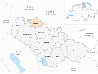
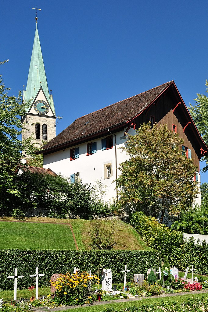
Kyburg
- former municipality of Switzerland
Hiking in Kyburg
Hiking in Kyburg, located near Zürich, Switzerland, offers a fantastic experience for outdoor enthusiasts. The area is known for its picturesque landscapes, rich history, and well-maintained hiking trails that cater to a variety of skill levels....
- Country:
- Postal Code: 8314
- Local Dialing Code: 052
- Licence Plate Code: ZH
- Coordinates: 47° 27' 28" N, 8° 44' 42" E
- GPS tracks (wikiloc): [Link]
- AboveSeaLevel: 625 м m
- Area: 7.58 sq km
- Population: 405
- Web site: [Link]

Dinhard
- municipality in Switzerland
Hiking in Dinhard
Dinhard, located in the canton of Thurgau in Switzerland, offers a picturesque setting for hiking enthusiasts. The region is characterized by its rolling hills, lush forests, and scenic views of the surrounding countryside....
- Country:
- Postal Code: 8474
- Local Dialing Code: 052
- Licence Plate Code: ZH
- Coordinates: 47° 33' 27" N, 8° 46' 11" E
- GPS tracks (wikiloc): [Link]
- AboveSeaLevel: 434 м m
- Area: 7.15 sq km
- Population: 1551
- Web site: [Link]

Seuzach
- municipality in Switzerland
Hiking in Seuzach
Seuzach, located in the Zurich region of Switzerland, offers a variety of hiking opportunities that cater to different fitness levels and preferences. The area is characterized by beautiful landscapes, rolling hills, and scenic views....
- Country:
- Postal Code: 8472
- Local Dialing Code: 052
- Licence Plate Code: ZH
- Coordinates: 47° 32' 9" N, 8° 43' 46" E
- GPS tracks (wikiloc): [Link]
- AboveSeaLevel: 455 м m
- Area: 7.56 sq km
- Population: 7291
- Web site: [Link]

Brütten
- municipality in Switzerland
Hiking in Brütten
Brütten is a charming village located in the Zurich region of Switzerland, and it offers several wonderful hiking opportunities for those looking to enjoy the beautiful Swiss landscapes. Here are some highlights of hiking in the Brütten area:...
- Country:
- Postal Code: 8311
- Local Dialing Code: 052
- Licence Plate Code: ZH
- Coordinates: 47° 28' 29" N, 8° 40' 21" E
- GPS tracks (wikiloc): [Link]
- AboveSeaLevel: 621 м m
- Area: 6.67 sq km
- Population: 2016
- Web site: [Link]

Zell
- municipality in Switzerland
Hiking in Zell
Zell im Zürich is a charming area that offers a variety of hiking opportunities, particularly appealing for both beginners and seasoned hikers. Nestled in the Zurich region, it features beautiful landscapes, lush forests, and scenic views of the surrounding mountains and Lake Zurich....
- Country:
- Postal Code: 8483, 8486, 8487
- Local Dialing Code: 052
- Licence Plate Code: ZH
- Coordinates: 47° 26' 56" N, 8° 49' 24" E
- GPS tracks (wikiloc): [Link]
- AboveSeaLevel: 541 м m
- Area: 12.70 sq km
- Population: 5929
- Web site: [Link]

Schlatt bei Winterthur
- municipality in Switzerland
Hiking in Schlatt bei Winterthur
Schlatt bei Winterthur is a charming municipality located near Winterthur in Switzerland, offering various hiking opportunities amidst beautiful landscapes. The region is known for its picturesque scenery, including rolling hills, lush forests, and scenic views....
- Country:
- Postal Code: 8418
- Local Dialing Code: 052
- Licence Plate Code: ZH
- Coordinates: 47° 28' 14" N, 8° 49' 37" E
- GPS tracks (wikiloc): [Link]
- AboveSeaLevel: 672 м m
- Area: 9.03 sq km
- Population: 730
- Web site: [Link]

Rickenbach
- municipality in the canton of Zurich, Switzerland
Hiking in Rickenbach
Rickenbach, located near Zurich, is a charming destination for hiking enthusiasts. The region offers a mix of scenic trails set against the backdrop of the Swiss countryside and the nearby Swiss Alps. Here are some key points to consider when planning your hiking adventure in Rickenbach:...
- Country:
- Postal Code: 8545
- Local Dialing Code: 052
- Licence Plate Code: ZH
- Coordinates: 47° 33' 4" N, 8° 47' 36" E
- GPS tracks (wikiloc): [Link]
- AboveSeaLevel: 416 м m
- Area: 6.03 sq km
- Population: 2655
- Web site: [Link]