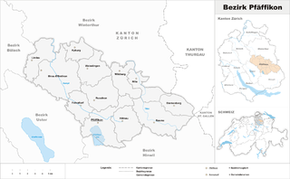
Winterthur District (Bezirk Winterthur)

- district of the canton of Zürich, Switzerland
 Hiking in Winterthur District
Hiking in the Winterthur District, located in the canton of Zurich, Switzerland, offers a wonderful blend of natural beauty, cultural heritage, and well-maintained trails. Here are some key aspects to consider for hiking in this area:
Trails and Terrain
-
Variety of Trails: The Winterthur District features a range of hiking trails, from easy walks to more challenging hikes. Trails often connect to nearby forests, meadows, and hills, making it suitable for hikers of all skill levels.
-
Scenic Views: Many trails in the region offer stunning views of the surrounding landscape, including the Zurich Oberland and the picturesque hills of the Zürcher Weinland.
-
Signposted Paths: Trails are generally well-marked with signs indicating directions, distances, and estimated hiking times, making navigation fairly straightforward.
Popular Hiking Areas
-
Eschenberg Forest: This area provides several hiking trails with varying levels of difficulty and is rich in wildlife. There are also spots for picnicking, making it a family-friendly option.
-
Kloten Mountain: A moderately challenging hike that rewards you with panoramic views over the Zurich area. Along the way, you can enjoy the diverse flora and fauna.
-
Usterwald: A beautiful forest area ideal for leisurely walks and hikes, it features well-marked trails suitable for families and beginner hikers.
Accessibility
-
Public Transport: The Winterthur District is well-connected by public transport, with easy access to trailheads via trains and buses. This makes it convenient for hikers coming from Zurich or other nearby locations.
-
Trail Conditions: Most trails are well-maintained and accessible year-round, though it’s advisable to check conditions, especially in winter or after heavy rainfall.
Safety and Tips
-
Gear Up: Make sure to wear appropriate hiking gear, including sturdy footwear, and dress in layers to accommodate changing temperatures.
-
Weather Conditions: Check the weather forecast before heading out, as conditions can change rapidly, particularly in the mountains.
-
Hydration and Snacks: Always carry enough water and some snacks to keep your energy levels up during your hike.
-
Respect Nature: Follow local guidelines for trail use, stay on marked paths, and respect wildlife and vegetation.
Events and Culture
Keep an eye out for local events like guided hikes or nature workshops, which can enrich your outdoor experience and provide insight into the local ecosystem and culture.
Whether you're a seasoned hiker or just looking for a pleasant outdoor experience, Winterthur District has something to offer everyone. Enjoy the beautiful Swiss nature!
- Country:

- Capital: Winterthur
- Licence Plate Code: ZH
- Coordinates: 47° 30' 0" N, 8° 46' 0" E


- GPS tracks (wikiloc): [Link]
- AboveSeaLevel: 460 м m
- Area: 251.30 sq km
- Wikipedia en: wiki(en)
- Wikipedia: wiki(de)
- Wikidata storage: Wikidata: Q644300
- Wikipedia Commons Category: [Link]
- Freebase ID: [/m/026nczy]
- GeoNames ID: Alt: [6458808]
- BnF ID: [12313625w]
- VIAF ID: Alt: [238758217]
- GND ID: Alt: [4447327-8]
- archINFORM location ID: [42721]
Includes regions:

Elsau
- municipality in Switzerland
Hiking in Elsau
Elsau, located in Switzerland, offers a range of beautiful hiking opportunities for both beginners and experienced hikers. Its picturesque landscapes, including lush greenery, rolling hills, and scenic views, make it an appealing destination for outdoor enthusiasts....
- Country:
- Postal Code: 8352
- Local Dialing Code: 052
- Licence Plate Code: ZH
- Coordinates: 47° 30' 22" N, 8° 48' 10" E
- GPS tracks (wikiloc): [Link]
- AboveSeaLevel: 498 м m
- Area: 8.06 sq km
- Population: 3631
- Web site: [Link]

Wiesendangen
- municipality in Switzerland
Hiking in Wiesendangen
Wiesendangen, located in the canton of Zurich in Switzerland, is a beautiful area for hiking enthusiasts. Nestled within the picturesque Swiss landscape, it offers a variety of trails suitable for different skill levels. Here are some key points to consider if you're planning a hiking trip in Wiesendangen:...
- Country:
- Postal Code: 8542, 8543
- Local Dialing Code: 052
- Licence Plate Code: ZH
- Coordinates: 47° 31' 20" N, 8° 47' 28" E
- GPS tracks (wikiloc): [Link]
- AboveSeaLevel: 469 м m
- Area: 9.68 sq km
- Population: 6380
- Web site: [Link]

Hettlingen
- municipality in Switzerland
Hiking in Hettlingen
Hettlingen, located in the scenic Zurich Oberland region of Switzerland, offers a variety of hiking opportunities that cater to different skill levels. With its picturesque landscapes, lush forests, and charming rural settings, Hettlingen is a great destination for both casual walkers and seasoned hikers....
- Country:
- Postal Code: 8442
- Local Dialing Code: 052
- Licence Plate Code: ZH
- Coordinates: 47° 32' 52" N, 8° 42' 35" E
- GPS tracks (wikiloc): [Link]
- AboveSeaLevel: 428 м m
- Area: 5.87 sq km
- Population: 3179
- Web site: [Link]

Neftenbach
- municipality in Switzerland
Hiking in Neftenbach
Neftenbach is a charming village located in the Zurich district of Switzerland, surrounded by beautiful natural landscapes that offer fantastic hiking opportunities. The region is characterized by its scenic hills, quiet forests, and picturesque views of the surrounding countryside. Here are some highlights for hiking in and around Neftenbach:...
- Country:
- Postal Code: 8413
- Local Dialing Code: 052
- Licence Plate Code: ZH
- Coordinates: 47° 31' 42" N, 8° 40' 5" E
- GPS tracks (wikiloc): [Link]
- AboveSeaLevel: 415 м m
- Area: 14.95 sq km
- Population: 5692
- Web site: [Link]

Pfungen
- municipality in Switzerland
Hiking in Pfungen
Pfungen is a charming village located in the Canton of Zurich, Switzerland. While it may not be as widely known as some larger hiking destinations in the region, it is surrounded by beautiful landscapes that offer various hiking opportunities....
- Country:
- Postal Code: 8422
- Local Dialing Code: 052
- Licence Plate Code: ZH
- Coordinates: 47° 30' 40" N, 8° 38' 33" E
- GPS tracks (wikiloc): [Link]
- AboveSeaLevel: 431 м m
- Area: 4.99 sq km
- Population: 3851
- Web site: [Link]

Ellikon an der Thur
- municipality in Switzerland
Hiking in Ellikon an der Thur
Ellikon an der Thur is a picturesque village located in the canton of Zurich, Switzerland. Nestled in a scenic area along the banks of the Thur River, it offers various hiking opportunities that cater to different skill levels. Here are some highlights of hiking in and around Ellikon an der Thur:...
- Country:
- Postal Code: 8548
- Local Dialing Code: 052
- Licence Plate Code: ZH
- Coordinates: 47° 33' 51" N, 8° 49' 32" E
- GPS tracks (wikiloc): [Link]
- AboveSeaLevel: 399 м m
- Area: 4.92 sq km
- Population: 903
- Web site: [Link]

Bertschikon bei Attikon
- former municipality in Switzerland
Hiking in Bertschikon bei Attikon
Bertschikon bei Attikon is a charming village located in the Canton of Zurich, Switzerland. The area surrounding this village offers a variety of hiking opportunities that cater to different skill levels. Here are some highlights for hiking in and around Bertschikon bei Attikon:...
- Country:
- Local Dialing Code: 052
- Licence Plate Code: ZH
- Coordinates: 47° 31' 38" N, 8° 48' 51" E
- GPS tracks (wikiloc): [Link]
- AboveSeaLevel: 504 м m
- Area: 9.64 sq km
- Web site: [Link]

Hofstetten
- municipality in Switzerland
Hiking in Hofstetten
Hofstetten is a charming area near Zürich, Switzerland, offering a range of hiking opportunities for outdoor enthusiasts. Located on the outskirts of Zürich, it provides a perfect blend of urban accessibility and natural beauty....
- Country:
- Postal Code: 8354
- Local Dialing Code: 052
- Licence Plate Code: ZH
- Coordinates: 47° 28' 25" N, 8° 51' 19" E
- GPS tracks (wikiloc): [Link]
- AboveSeaLevel: 642 м m
- Area: 8.85 sq km
- Population: 500
- Web site: [Link]

Dinhard
- municipality in Switzerland
Hiking in Dinhard
Dinhard, located in the canton of Thurgau in Switzerland, offers a picturesque setting for hiking enthusiasts. The region is characterized by its rolling hills, lush forests, and scenic views of the surrounding countryside....
- Country:
- Postal Code: 8474
- Local Dialing Code: 052
- Licence Plate Code: ZH
- Coordinates: 47° 33' 27" N, 8° 46' 11" E
- GPS tracks (wikiloc): [Link]
- AboveSeaLevel: 434 м m
- Area: 7.15 sq km
- Population: 1551
- Web site: [Link]

Seuzach
- municipality in Switzerland
Hiking in Seuzach
Seuzach, located in the Zurich region of Switzerland, offers a variety of hiking opportunities that cater to different fitness levels and preferences. The area is characterized by beautiful landscapes, rolling hills, and scenic views....
- Country:
- Postal Code: 8472
- Local Dialing Code: 052
- Licence Plate Code: ZH
- Coordinates: 47° 32' 9" N, 8° 43' 46" E
- GPS tracks (wikiloc): [Link]
- AboveSeaLevel: 455 м m
- Area: 7.56 sq km
- Population: 7291
- Web site: [Link]

Brütten
- municipality in Switzerland
Hiking in Brütten
Brütten is a charming village located in the Zurich region of Switzerland, and it offers several wonderful hiking opportunities for those looking to enjoy the beautiful Swiss landscapes. Here are some highlights of hiking in the Brütten area:...
- Country:
- Postal Code: 8311
- Local Dialing Code: 052
- Licence Plate Code: ZH
- Coordinates: 47° 28' 29" N, 8° 40' 21" E
- GPS tracks (wikiloc): [Link]
- AboveSeaLevel: 621 м m
- Area: 6.67 sq km
- Population: 2016
- Web site: [Link]


Turbenthal
- municipality in Switzerland
Hiking in Turbenthal
Turbenthal, a picturesque town located in the Canton of Zurich, Switzerland, offers various hiking opportunities that cater to different skill levels. Surrounded by lush landscapes, rolling hills, and scenic views of the Zurich Oberland, it is an ideal destination for both leisurely walks and more challenging hikes....
- Country:
- Postal Code: 8488
- Local Dialing Code: 052
- Licence Plate Code: ZH
- Coordinates: 47° 25' 56" N, 8° 52' 47" E
- GPS tracks (wikiloc): [Link]
- AboveSeaLevel: 600 м m
- Area: 25.07 sq km
- Population: 4748
- Web site: [Link]

Hagenbuch
- municipality in Switzerland
Hiking in Hagenbuch
Hagenbuch, while not a widely recognized hiking destination, offers beautiful natural landscapes and opportunities for outdoor activities. If you're planning to hike in the area, here are some general tips and information you might find useful:...
- Country:
- Postal Code: 8523
- Local Dialing Code: 052
- Licence Plate Code: ZH
- Coordinates: 47° 30' 59" N, 8° 52' 32" E
- GPS tracks (wikiloc): [Link]
- AboveSeaLevel: 606 м m
- Area: 8.17 sq km
- Population: 1105
- Web site: [Link]

Altikon
- municipality in Switzerland
Hiking in Altikon
Altikon is a charming village located in the canton of Zurich, Switzerland, and is surrounded by picturesque landscapes, making it a great destination for hiking enthusiasts. Here’s what you need to know about hiking in and around Altikon:...
- Country:
- Local Dialing Code: 052
- Licence Plate Code: ZH
- Coordinates: 47° 34' 38" N, 8° 47' 3" E
- GPS tracks (wikiloc): [Link]
- AboveSeaLevel: 377 м m
- Area: 7.68 sq km
- Population: 674
- Web site: [Link]

Elgg
- municipality in Switzerland
Hiking in Elgg
Elgg is a charming municipality located in the canton of Zurich, Switzerland. While it may not be as widely known for hiking as other areas in the Swiss Alps, it does offer some pleasant landscapes and trails suitable for outdoor enthusiasts. Here are a few things to consider when hiking in and around Elgg:...
- Country:
- Postal Code: 8353, 8354
- Local Dialing Code: 052
- Licence Plate Code: ZH
- Coordinates: 47° 29' 29" N, 8° 51' 52" E
- GPS tracks (wikiloc): [Link]
- AboveSeaLevel: 519 м m
- Area: 15.59 sq km
- Web site: [Link]

Zell
- municipality in Switzerland
Hiking in Zell
Zell im Zürich is a charming area that offers a variety of hiking opportunities, particularly appealing for both beginners and seasoned hikers. Nestled in the Zurich region, it features beautiful landscapes, lush forests, and scenic views of the surrounding mountains and Lake Zurich....
- Country:
- Postal Code: 8483, 8486, 8487
- Local Dialing Code: 052
- Licence Plate Code: ZH
- Coordinates: 47° 26' 56" N, 8° 49' 24" E
- GPS tracks (wikiloc): [Link]
- AboveSeaLevel: 541 м m
- Area: 12.70 sq km
- Population: 5929
- Web site: [Link]

Schlatt bei Winterthur
- municipality in Switzerland
Hiking in Schlatt bei Winterthur
Schlatt bei Winterthur is a charming municipality located near Winterthur in Switzerland, offering various hiking opportunities amidst beautiful landscapes. The region is known for its picturesque scenery, including rolling hills, lush forests, and scenic views....
- Country:
- Postal Code: 8418
- Local Dialing Code: 052
- Licence Plate Code: ZH
- Coordinates: 47° 28' 14" N, 8° 49' 37" E
- GPS tracks (wikiloc): [Link]
- AboveSeaLevel: 672 м m
- Area: 9.03 sq km
- Population: 730
- Web site: [Link]

Dägerlen
- municipality in Switzerland
Hiking in Dägerlen
Dägerlen is a charming town located in the Swiss canton of Zurich, nestled in the picturesque Swiss landscape. While it may not be as widely known as some other hiking destinations in Switzerland, it offers some lovely trails that take you through beautiful natural scenery, including forests, meadows, and views of the surrounding hills....
- Country:
- Postal Code: 8471
- Local Dialing Code: 052
- Licence Plate Code: ZH
- Coordinates: 47° 33' 43" N, 8° 43' 23" E
- GPS tracks (wikiloc): [Link]
- AboveSeaLevel: 474 м m
- Area: 7.95 sq km
- Population: 1012
- Web site: [Link]

Rickenbach
- municipality in the canton of Zurich, Switzerland
Hiking in Rickenbach
Rickenbach, located near Zurich, is a charming destination for hiking enthusiasts. The region offers a mix of scenic trails set against the backdrop of the Swiss countryside and the nearby Swiss Alps. Here are some key points to consider when planning your hiking adventure in Rickenbach:...
- Country:
- Postal Code: 8545
- Local Dialing Code: 052
- Licence Plate Code: ZH
- Coordinates: 47° 33' 4" N, 8° 47' 36" E
- GPS tracks (wikiloc): [Link]
- AboveSeaLevel: 416 м m
- Area: 6.03 sq km
- Population: 2655
- Web site: [Link]

Dättlikon
- municipality in Switzerland
Hiking in Dättlikon
Dättlikon is a picturesque area located in Switzerland, known for its beautiful landscapes and outdoor activities, including hiking. While Dättlikon itself may not have an extensive trail system, it serves as a gateway to the surrounding regions that offer a variety of hiking opportunities....
- Country:
- Postal Code: 8421
- Local Dialing Code: 052
- Licence Plate Code: ZH
- Coordinates: 47° 31' 34" N, 8° 37' 31" E
- GPS tracks (wikiloc): [Link]
- AboveSeaLevel: 386 м m
- Area: 2.89 sq km
- Population: 783
- Web site: [Link]
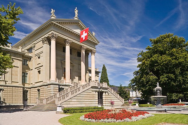
Winterthur
- city in the canton of Zürich, Switzerland
Hiking in Winterthur
Winterthur, located in the canton of Zurich in Switzerland, is a great destination for hiking enthusiasts. The region is known for its beautiful landscapes, rich cultural heritage, and well-marked hiking trails that cater to different skill levels. Here are some highlights for hiking in and around Winterthur:...
- Country:
- Postal Code: 8542; 8400; 8482; 8352; 8310; 8400–8411
- Local Dialing Code: 052
- Licence Plate Code: ZH
- Coordinates: 47° 29' 57" N, 8° 43' 36" E
- GPS tracks (wikiloc): [Link]
- AboveSeaLevel: 439 м m
- Area: 68.05 sq km
- Population: 109775
- Web site: [Link]
Shares border with regions:

Pfäffikon District
- district of the canton of Zürich, Switzerland
Hiking in Pfäffikon District
Pfäffikon District, located in the canton of Zurich, Switzerland, offers a picturesque landscape that's ideal for hiking enthusiasts. It's characterized by rolling hills, lush forests, and scenic lakes, making it a beautiful destination for outdoor activities....
- Country:
- Capital: Pfäffikon
- Licence Plate Code: ZH
- Coordinates: 47° 24' 0" N, 8° 47' 0" E
- GPS tracks (wikiloc): [Link]
- AboveSeaLevel: 715 м m
- Area: 163.55 sq km

Andelfingen District
- district of the canton of Zürich, Switzerland
Hiking in Andelfingen District
Andelfingen District, located in the canton of Zurich, Switzerland, is a picturesque area that offers a variety of hiking opportunities. The region is characterized by rolling hills, vineyards, and scenic views, making it an excellent destination for outdoor enthusiasts....
- Country:
- Licence Plate Code: ZH
- Coordinates: 47° 37' 0" N, 8° 40' 0" E
- GPS tracks (wikiloc): [Link]
- AboveSeaLevel: 424 м m
- Area: 166.59 sq km


Bülach District
- district of the canton of Zürich, Switzerland
Hiking in Bülach District
Bülach District, located in the Canton of Zurich in Switzerland, offers a variety of hiking opportunities that cater to different skill levels and preferences. The region is characterized by beautiful landscapes, cultivated fields, lush forests, and historic towns....
- Country:
- Capital: Bülach
- Licence Plate Code: ZH
- Coordinates: 47° 40' 0" N, 8° 34' 0" E
- GPS tracks (wikiloc): [Link]
- AboveSeaLevel: 564 м m
- Area: 185.19 sq km
- Population: 117000