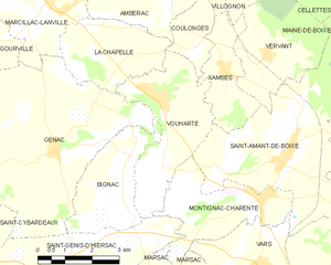
Xambes (Xambes)

- commune in Charente, France
- Country:

- Postal Code: 16330
- Coordinates: 45° 49' 35" N, 0° 6' 18" E


- GPS tracks (wikiloc): [Link]
- Area: 5.25 sq km
- Population: 312
- Wikipedia en: wiki(en)
- Wikipedia: wiki(fr)
- Wikidata storage: Wikidata: Q379001
- Wikipedia Commons Category: [Link]
- Freebase ID: [/m/03mcflg]
- GeoNames ID: Alt: [2967276]
- SIREN number: [211604236]
- BnF ID: [152488601]
- INSEE municipality code: 16423
Shares border with regions:


Coulonges
- commune in Charente, France
- Country:
- Postal Code: 16330
- Coordinates: 45° 50' 0" N, 0° 5' 26" E
- GPS tracks (wikiloc): [Link]
- AboveSeaLevel: 100 м m
- Area: 3.02 sq km
- Population: 149


Villognon
- commune in Charente, France
- Country:
- Postal Code: 16230
- Coordinates: 45° 51' 42" N, 0° 5' 56" E
- GPS tracks (wikiloc): [Link]
- Area: 9.17 sq km
- Population: 333

Vouharte
- commune in Charente, France
- Country:
- Postal Code: 16330
- Coordinates: 45° 48' 56" N, 0° 4' 28" E
- GPS tracks (wikiloc): [Link]
- Area: 10.64 sq km
- Population: 325

Vervant
- commune in Charente, France
- Country:
- Postal Code: 16330
- Coordinates: 45° 49' 56" N, 0° 7' 25" E
- GPS tracks (wikiloc): [Link]
- Area: 9.56 sq km
- Population: 147


Saint-Amant-de-Boixe
- commune in Charente, France
- Country:
- Postal Code: 16330
- Coordinates: 45° 47' 53" N, 0° 8' 5" E
- GPS tracks (wikiloc): [Link]
- Area: 22.39 sq km
- Population: 1416
- Web site: [Link]