Yzeron (Yzeron)
- commune in Rhône, France
- Country:

- Postal Code: 69510
- Coordinates: 45° 42' 29" N, 4° 35' 28" E


- GPS tracks (wikiloc): [Link]
- Area: 10.75 sq km
- Population: 1055
- Web site: http://www.yzeron.com
- Wikipedia en: wiki(en)
- Wikipedia: wiki(fr)
- Wikidata storage: Wikidata: Q589949
- Wikipedia Commons Category: [Link]
- Freebase ID: [/m/03qggd_]
- Freebase ID: [/m/03qggd_]
- GeoNames ID: Alt: [6441816]
- GeoNames ID: Alt: [6441816]
- SIREN number: [216902692]
- SIREN number: [216902692]
- BnF ID: [152723557]
- BnF ID: [152723557]
- WOEID: [633090]
- WOEID: [633090]
- INSEE municipality code: 69269
- INSEE municipality code: 69269
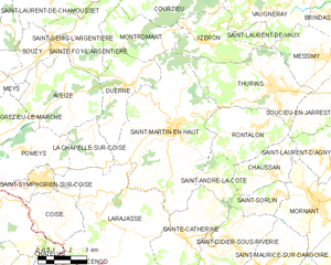
Shares border with regions:


Montromant
- commune in Rhône, France
- Country:

- Postal Code: 69610
- Coordinates: 45° 42' 29" N, 4° 31' 32" E


- GPS tracks (wikiloc): [Link]
- Area: 10.99 sq km
- Population: 451
- Web site: [Link]


Saint-Martin-en-Haut
- commune in Rhône, France
- Country:

- Postal Code: 69850
- Coordinates: 45° 39' 35" N, 4° 33' 42" E


- GPS tracks (wikiloc): [Link]
- Area: 38.64 sq km
- Population: 3907
- Web site: [Link]


Courzieu
- commune in Rhône, France
- Country:

- Postal Code: 69690
- Coordinates: 45° 44' 34" N, 4° 34' 15" E


- GPS tracks (wikiloc): [Link]
- Area: 27.04 sq km
- Population: 1071


Vaugneray
- former commune in Rhône, France
- Country:

- Postal Code: 69670
- Coordinates: 45° 44' 16" N, 4° 39' 23" E


- GPS tracks (wikiloc): [Link]
- Area: 22.38 sq km
- Population: 5130
- Web site: [Link]


Thurins
- commune in Rhône, France
- Country:

- Postal Code: 69510
- Coordinates: 45° 40' 54" N, 4° 38' 27" E


- GPS tracks (wikiloc): [Link]
- Area: 19.36 sq km
- Population: 3015
- Web site: [Link]


Messimy
- commune in Rhône, France
- Country:

- Postal Code: 69510
- Coordinates: 45° 41' 53" N, 4° 40' 27" E


- GPS tracks (wikiloc): [Link]
- AboveSeaLevel: 350 м m
- Area: 11.1 sq km
- Population: 3387
- Web site: [Link]
