Zofingen District (Bezirk Zofingen)

- district in the canton of Aargau, Switzerland
 Hiking in Zofingen District
Zofingen District, located in Switzerland's Aargau region, offers a variety of hiking opportunities amid beautiful landscapes, charming villages, and panoramic views. The district is a great location for both casual walkers and more experienced hikers. Here are some highlights and tips for hiking in the Zofingen District:
Scenic Trails
- Zofingen to Brittnau: This trail offers a pleasant walk with picturesque views of the surrounding countryside. It's relatively easy and suitable for families.
- Vorderrhein Valley: This area has more challenging trails with varied terrain. Be prepared for some ascents, but the views of the valley are worth the effort.
- Hiking around the Wiggertal: This region features scenic routes alongside rivers and through forests, making it perfect for nature lovers.
Attractions
- Zofingen Town: Make sure to explore the historic town of Zofingen itself, known for its medieval architecture and vibrant town center.
- Local Parks and Nature Reserves: While hiking, you can find various parks and natural reserves that highlight the region's biodiversity.
Hiking Tips
- Weather Readiness: Swiss weather can change quickly, so check forecasts and be prepared for rain or sudden temperature drops.
- Proper Gear: Wear suitable footwear and carry a backpack with essentials like water, snacks, a first aid kit, and a map.
- Trail Maps and Signage: The trails are generally well-marked, but carrying a detailed map can help if you venture off the beaten path.
- Respect Wildlife: Stay on marked paths to protect local wildlife and plants.
Accessibility
- The district is easily accessible via public transport, making it convenient for day hikes or longer excursions. Local train services connect Zofingen with various hiking starting points.
Local Experience
Consider visiting in different seasons for varied experiences—lush greenery in spring and summer, vibrant colors in autumn, or snowy trails in winter.
Whether you're seeking a leisurely walk or a challenging hike, Zofingen District has options to meet your needs while allowing you to experience the stunning Swiss landscape.
- Country:

- Capital: Zofingen
- Coordinates: 47° 17' 0" N, 7° 56' 0" E


- GPS tracks (wikiloc): [Link]
- AboveSeaLevel: 486 м m
- Area: 142.01 sq km
- Wikipedia en: wiki(en)
- Wikipedia: wiki(de)
- Wikidata storage: Wikidata: Q659332
- Wikipedia Commons Category: [Link]
- Freebase ID: [/m/042bhn]
- GeoNames ID: Alt: [6458746]
- archINFORM location ID: [43361]
Includes regions:


Zofingen
- city in the canton of Aargau, Switzerland
Hiking in Zofingen
Zofingen, located in the canton of Aargau in Switzerland, offers a charming backdrop for hiking enthusiasts. This region is characterized by its rolling hills, scenic landscapes, and picturesque views, making it an attractive destination for hikers of all skill levels....
- Country:
- Postal Code: 4800
- Local Dialing Code: 062
- Licence Plate Code: AG
- Coordinates: 47° 17' 18" N, 7° 56' 51" E
- GPS tracks (wikiloc): [Link]
- AboveSeaLevel: 549 м m
- Area: 11.07 sq km
- Population: 11561
- Web site: [Link]


Aarburg
- municipality in the district of Zofingen in the canton of Aargau in Switzerland
Hiking in Aarburg
Aarburg, located in the canton of Aargau in Switzerland, is a charming town that serves as a great starting point for various hiking opportunities in the surrounding region. The area is known for its picturesque landscapes, rich history, and beautiful natural scenery, making it appealing for hikers of all levels....
- Country:
- Postal Code: 4663
- Local Dialing Code: 062
- Licence Plate Code: AG
- Coordinates: 47° 19' 14" N, 7° 54' 5" E
- GPS tracks (wikiloc): [Link]
- AboveSeaLevel: 459 м m
- Area: 4.41 sq km
- Population: 8068
- Web site: [Link]


Vordemwald
- municipality in Switzerland
Hiking in Vordemwald
Vordemwald is a picturesque village located in the canton of Aargau in Switzerland, surrounded by beautiful natural landscapes that are ideal for hiking enthusiasts. Here are some highlights and tips for hiking in and around Vordemwald:...
- Country:
- Postal Code: 4803
- Local Dialing Code: 062
- Licence Plate Code: AG
- Coordinates: 47° 16' 12" N, 7° 53' 32" E
- GPS tracks (wikiloc): [Link]
- AboveSeaLevel: 461 м m
- Area: 10.15 sq km
- Population: 1943
- Web site: [Link]


Strengelbach
- municipality in Switzerland
Hiking in Strengelbach
Strengelbach, located in the canton of Aargau, Switzerland, offers a variety of hiking opportunities in a picturesque setting. The region is known for its rolling hills, lush forests, and scenic views, making it an ideal destination for both casual walkers and seasoned hikers....
- Country:
- Postal Code: 4802
- Local Dialing Code: 062
- Licence Plate Code: AG
- Coordinates: 47° 16' 54" N, 7° 55' 22" E
- GPS tracks (wikiloc): [Link]
- AboveSeaLevel: 496 м m
- Area: 6.03 sq km
- Population: 4820
- Web site: [Link]
Staffelbach
- municipality in the canton Aargau, Switzerland
Hiking in Staffelbach
Staffelbach is a small municipality in Switzerland, located in the canton of Aargau. While it might not be as widely known for hiking as some larger areas, it offers opportunities for outdoor enthusiasts to explore its local landscapes....
- Country:
- Postal Code: 5053
- Local Dialing Code: 062
- Licence Plate Code: AG
- Coordinates: 47° 16' 59" N, 8° 2' 50" E
- GPS tracks (wikiloc): [Link]
- AboveSeaLevel: 484 м m
- Area: 8.94 sq km
- Population: 1236
- Web site: [Link]


Wiliberg
- municipality in the district of Zofingen in the canton of Aargau in Switzerland
Hiking in Wiliberg
Wiliberg, located in Switzerland, offers a variety of hiking opportunities that cater to different skill levels and preferences. The region is known for its stunning alpine scenery, diverse landscapes, and well-marked trails....
- Country:
- Postal Code: 5058
- Local Dialing Code: 062
- Licence Plate Code: AG
- Coordinates: 47° 16' 1" N, 8° 1' 0" E
- GPS tracks (wikiloc): [Link]
- AboveSeaLevel: 597 м m
- Area: 1.17 sq km
- Population: 164
- Web site: [Link]

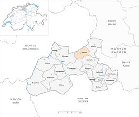
Bottenwil
- municipality in Switzerland
Hiking in Bottenwil
Bottenwil is a small municipality located in the Canton of Aargau, Switzerland, and offers a variety of hiking opportunities that allow you to explore the beautiful Swiss countryside. While the area itself may not be as renowned as some larger hiking destinations, it serves as a great base for accessing the picturesque landscape of Aargau....
- Country:
- Postal Code: 4814
- Local Dialing Code: 062
- Licence Plate Code: AG
- Coordinates: 47° 17' 7" N, 8° 0' 11" E
- GPS tracks (wikiloc): [Link]
- AboveSeaLevel: 498 м m
- Area: 5.10 sq km
- Population: 790
- Web site: [Link]


Brittnau
- municipality in Switzerland
Hiking in Brittnau
Brittnau is located in the canton of Aargau in Switzerland, surrounded by beautiful landscapes that make it a great destination for hiking enthusiasts. The area offers a variety of trails suitable for different skill levels, from easy strolls through scenic countryside to more challenging hikes in nearby hills....
- Country:
- Postal Code: 4805
- Local Dialing Code: 062
- Licence Plate Code: AG
- Coordinates: 47° 15' 17" N, 7° 55' 39" E
- GPS tracks (wikiloc): [Link]
- AboveSeaLevel: 538 м m
- Area: 13.67 sq km
- Population: 3900
- Web site: [Link]


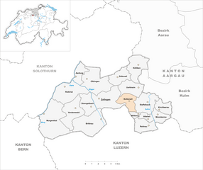
Uerkheim
- municipality in Switzerland
Hiking in Uerkheim
Uerkheim is a charming village located in the canton of Aargau in Switzerland. While it may not be as famous as some of the larger towns or cities in Switzerland, it offers a lovely environment for hiking enthusiasts who appreciate quieter landscapes and local nature....
- Country:
- Postal Code: 4813
- Local Dialing Code: 062
- Licence Plate Code: AG
- Coordinates: 47° 18' 13" N, 8° 0' 33" E
- GPS tracks (wikiloc): [Link]
- AboveSeaLevel: 492 м m
- Area: 7.09 sq km
- Population: 1346
- Web site: [Link]


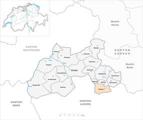
Attelwil
- municipality in Switzerland
Hiking in Attelwil
Attelwil is a charming village located in the Swiss region of Aargau, surrounded by beautiful landscapes and numerous hiking opportunities. Here are some insights and tips for hiking in and around Attelwil:...
- Country:
- Postal Code: 5056
- Local Dialing Code: 062
- Licence Plate Code: AG
- Coordinates: 47° 15' 34" N, 8° 2' 40" E
- GPS tracks (wikiloc): [Link]
- AboveSeaLevel: 547 м m
- Area: 2.19 sq km
- Population: 295
- Web site: [Link]

Reitnau
- municipality in Switzerland
Hiking in Reitnau
Reitnau is a charming village located in the Canton of Aargau, Switzerland, known for its picturesque landscapes and serene surroundings. Hiking in Reitnau offers opportunities to explore the beautiful Swiss countryside, characterized by rolling hills, lush forests, and panoramic views of the Alps and surrounding valleys....
- Country:
- Postal Code: 5057
- Local Dialing Code: 062
- Licence Plate Code: AG
- Coordinates: 47° 15' 8" N, 8° 2' 32" E
- GPS tracks (wikiloc): [Link]
- AboveSeaLevel: 540 м m
- Area: 5.79 sq km
- Population: 1275
- Web site: [Link]
Moosleerau
- municipality in Switzerland
Hiking in Moosleerau
Moosleerau, located in Switzerland, is a hidden gem for hiking enthusiasts. Surrounded by picturesque landscapes, it offers a variety of trails that cater to different skill levels....
- Country:
- Postal Code: 5054
- Local Dialing Code: 062
- Licence Plate Code: AG
- Coordinates: 47° 15' 52" N, 8° 3' 58" E
- GPS tracks (wikiloc): [Link]
- AboveSeaLevel: 534 м m
- Area: 3.81 sq km
- Population: 925
- Web site: [Link]

Safenwil
- municipality in Switzerland
Hiking in Safenwil
Safenwil, located in the Canton of Aargau in Switzerland, offers a beautiful setting for hiking enthusiasts. The region is characterized by its scenic landscapes, including rolling hills, forests, and picturesque farms. Here are some insights for hiking in and around Safenwil:...
- Country:
- Postal Code: 5745
- Local Dialing Code: 062
- Licence Plate Code: AG
- Coordinates: 47° 19' 11" N, 7° 59' 13" E
- GPS tracks (wikiloc): [Link]
- AboveSeaLevel: 494 м m
- Area: 5.99 sq km
- Population: 3798
- Web site: [Link]


Kirchleerau
- municipality in Switzerland
Hiking in Kirchleerau
Kirchleerau is a small village located in the Canton of Aargau in Switzerland, surrounded by picturesque landscapes and natural beauty, making it a great spot for hiking enthusiasts....
- Country:
- Postal Code: 5054
- Local Dialing Code: 062
- Licence Plate Code: AG
- Coordinates: 47° 16' 38" N, 8° 4' 27" E
- GPS tracks (wikiloc): [Link]
- AboveSeaLevel: 533 м m
- Area: 4.36 sq km
- Population: 854
- Web site: [Link]


Murgenthal
- municipality in Switzerland
Hiking in Murgenthal
Murgenthal, located in the Aargau region of Switzerland, offers several beautiful hiking opportunities amidst stunning natural landscapes. The area is characterized by rolling hills, forests, and picturesque views of the surrounding countryside. Here are a few key details to consider when planning a hike in Murgenthal:...
- Country:
- Postal Code: 4853
- Local Dialing Code: 062
- Licence Plate Code: AG
- Coordinates: 47° 16' 4" N, 7° 50' 9" E
- GPS tracks (wikiloc): [Link]
- AboveSeaLevel: 410 м m
- Area: 18.61 sq km
- Population: 2912
- Web site: [Link]


Rothrist
- municipality in Switzerland
Hiking in Rothrist
Rothrist is a charming municipality in the canton of Aargau, Switzerland, offering scenic hiking opportunities surrounded by beautiful landscapes. The region features a mix of gentle hills, lush valleys, and picturesque views, making it a great spot for both novice and experienced hikers....
- Country:
- Postal Code: 4852
- Local Dialing Code: 062
- Licence Plate Code: AG
- Coordinates: 47° 17' 54" N, 7° 53' 7" E
- GPS tracks (wikiloc): [Link]
- AboveSeaLevel: 462 м m
- Area: 11.87 sq km
- Population: 8927
- Web site: [Link]


Kölliken
- municipality in Switzerland
Hiking in Kölliken
Kölliken is a charming area located in the canton of Aargau, Switzerland. Although it may not be as widely known as some major hiking destinations in the Swiss Alps, it offers some lovely trails that provide a great experience for hikers....
- Country:
- Postal Code: 5742
- Local Dialing Code: 062
- Licence Plate Code: AG
- Coordinates: 47° 20' 1" N, 8° 1' 15" E
- GPS tracks (wikiloc): [Link]
- AboveSeaLevel: 427 м m
- Area: 8.89 sq km
- Population: 4342
- Web site: [Link]


Oftringen
- municipality in Switzerland
Hiking in Oftringen
Oftringen, located in Switzerland, is a charming municipality in the canton of Aargau. It offers a variety of hiking opportunities suitable for different skill levels. Here are some highlights and considerations for hiking in and around Oftringen:...
- Country:
- Postal Code: 4665
- Local Dialing Code: 062
- Licence Plate Code: AG
- Coordinates: 47° 18' 48" N, 7° 56' 20" E
- GPS tracks (wikiloc): [Link]
- AboveSeaLevel: 433 м m
- Area: 12.85 sq km
- Population: 13606
- Web site: [Link]