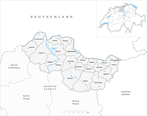
Zurzach District (Bezirk Zurzach)

- district in Switzerland
 Hiking in Zurzach District
Zurzach District, located in the canton of Aargau in Switzerland, offers a variety of hiking opportunities that are perfect for both casual walkers and avid hikers. The area is known for its picturesque landscapes, charming villages, and historical sites. Here are some highlights and tips for hiking in the Zurzach District:
Scenic Trails
-
Rhine River Trail: This trail follows the scenic Rhine River and offers stunning views of the water, meadows, and surrounding countryside. It's a great option for day hikes and can be enjoyed at a leisurely pace.
-
Hiking in the Jura Mountains: Just a bit further afield, you can find trails that lead into the Jura mountains, providing more challenging terrain and breathtaking panoramas of the Swiss landscape.
-
Local Forest Trails: The district is dotted with beautiful forested areas. Trails through these woods are perfect for families and those seeking a more tranquil hiking experience.
Historical Sites
- Historical Villages: Along your hike, you can explore quaint villages such as Zurzach itself, which boasts a charming old town with historical buildings and monuments.
- Thermal Springs: The region is known for its thermal baths; consider planning a hike that ends with a relaxing soak in one of the local spas.
Flora and Fauna
- The diverse ecosystems in the Zurzach District provide habitat for various wildlife and plant species, making it a great destination for nature lovers. Keep an eye out for local birds and other wildlife along your hikes.
Seasonal Considerations
- Spring and Summer: These seasons typically offer the best weather for hiking. The trails are adorned with flowers and lush greenery, making for beautiful scenery.
- Autumn: The fall colors in the region can be stunning, and the cooler weather is great for hiking without the summer crowds.
- Winter Hiking: While some trails may be less accessible due to snow, the region also offers winter hiking routes that can be quite scenic.
Tips for Hiking in Zurzach District
- Trail Maps: Always carry a detailed map or use a reliable hiking app to ensure you stay on the right path.
- Hydration and Snacks: Bring sufficient water and snacks, especially if you plan on longer hikes.
- Weather Check: Always check the weather forecast before heading out, as conditions can change rapidly.
- Respect the Environment: Follow Leave No Trace principles to ensure the natural beauty of the area is preserved for future hikers.
Accessibility
Most trails in the Zurzach District are well-marked and offer options for various skill levels, making it accessible for everyone from beginners to experienced hikers.
In summary, with its blend of natural beauty, historical significance, and well-maintained trails, the Zurzach District is a fantastic location for hiking and outdoor adventures in Switzerland. Whether you're looking for a relaxing stroll along the Rhine or a more rigorous climb in the Jura, you'll find a variety of options to suit your hiking desires!
- Country:

- Capital: Bad Zurzach
- Licence Plate Code: AG
- Coordinates: 47° 35' 0" N, 8° 17' 0" E


- GPS tracks (wikiloc): [Link]
- AboveSeaLevel: 349 м m
- Area: 129.99 sq km
- Web site: http://www.zurzibiet.ch/
- Wikipedia en: wiki(en)
- Wikipedia: wiki(de)
- Wikidata storage: Wikidata: Q659309
- Wikipedia Commons Category: [Link]
- Freebase ID: [/m/04htv8]
- GeoNames ID: Alt: [6458788]
- archINFORM location ID: [43360]
- PACTOLS thesaurus ID: [pcrt0q7EbJpl43]
Includes regions:


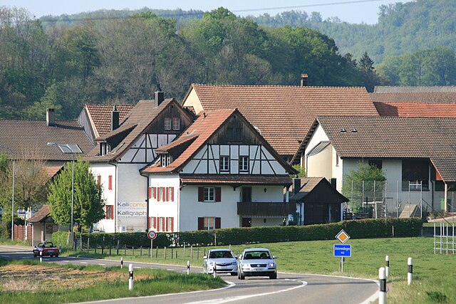
Bad Zurzach
- municipality in Switzerland
Hiking in Bad Zurzach
Bad Zurzach, located in the Aargau region of Switzerland near the border with Germany, offers a beautiful setting for hiking enthusiasts. Known for its thermal baths and wellness spa, Bad Zurzach also provides access to scenic trails that showcase the natural beauty of the area....
- Country:
- Postal Code: 5330
- Local Dialing Code: 056
- Licence Plate Code: AG
- Coordinates: 47° 35' 14" N, 8° 17' 40" E
- GPS tracks (wikiloc): [Link]
- AboveSeaLevel: 345 м m
- Area: 6.52 sq km
- Population: 4242
- Web site: [Link]


Tegerfelden
- municipality in Switzerland
Hiking in Tegerfelden
Tegerfelden is a small municipality located in the Aargau region of Switzerland, known for its picturesque landscapes and natural beauty. Hiking in Tegerfelden can offer a rewarding experience for both beginners and experienced hikers, thanks to its varied terrain and scenic views....
- Country:
- Postal Code: 5306
- Local Dialing Code: 056
- Licence Plate Code: AG
- Coordinates: 47° 33' 43" N, 8° 17' 5" E
- GPS tracks (wikiloc): [Link]
- AboveSeaLevel: 368 м m
- Area: 7.11 sq km
- Population: 1204
- Web site: [Link]


Schneisingen
- municipality in Switzerland
Hiking in Schneisingen
Schneisingen, located in Switzerland, offers beautiful landscapes and a variety of hiking opportunities. While it's a smaller region, it provides access to some stunning trails that are suitable for hikers of various skill levels. Here are a few aspects to consider when hiking in the area:...
- Country:
- Postal Code: 5425
- Local Dialing Code: 056
- Licence Plate Code: AG
- Coordinates: 47° 31' 30" N, 8° 21' 42" E
- GPS tracks (wikiloc): [Link]
- AboveSeaLevel: 532 м m
- Area: 8.26 sq km
- Population: 1391
- Web site: [Link]


Döttingen
- municipality in the canton Aargau, Switzerland
Hiking in Döttingen
Döttingen, located in the Aargau region of Switzerland, is a charming village that offers a variety of hiking opportunities. The area is characterized by its picturesque landscapes, including rolling hills, lush forests, and scenic views of the surrounding countryside....
- Country:
- Postal Code: 5312
- Local Dialing Code: 056
- Licence Plate Code: AG
- Coordinates: 47° 34' 14" N, 8° 15' 35" E
- GPS tracks (wikiloc): [Link]
- AboveSeaLevel: 328 м m
- Area: 6.93 sq km
- Population: 3747
- Web site: [Link]


Böttstein
- municipality in Switzerland
Hiking in Böttstein
Böttstein is a picturesque village located in the Aargau region of Switzerland, nestled along the banks of the Rhine River. The area offers a variety of scenic hiking opportunities that cater to different levels of experience and fitness....
- Country:
- Postal Code: 5315
- Local Dialing Code: 056
- Licence Plate Code: AG
- Coordinates: 47° 33' 24" N, 8° 13' 29" E
- GPS tracks (wikiloc): [Link]
- AboveSeaLevel: 350 м m
- Area: 7.43 sq km
- Population: 3986
- Web site: [Link]


Wislikofen
- municipality in Switzerland
Hiking in Wislikofen
Wislikofen is a quaint village in the Swiss canton of Aargau, nestled along the banks of the River Aare. It offers beautiful opportunities for hiking, with a variety of trails suitable for different skill levels. Here are some points to consider if you're planning to hike in and around Wislikofen:...
- Country:
- Postal Code: 5463
- Local Dialing Code: 056
- Licence Plate Code: AG
- Coordinates: 47° 33' 13" N, 8° 22' 0" E
- GPS tracks (wikiloc): [Link]
- AboveSeaLevel: 440 м m
- Area: 3.75 sq km
- Population: 338
- Web site: [Link]


Böbikon
- municipality in Switzerland
Hiking in Böbikon
Böbikon is a charming village located in the canton of Zurich, Switzerland, surrounded by beautiful landscapes that make it an excellent destination for hiking enthusiasts. Here are some points to consider when hiking in and around Böbikon:...
- Country:
- Postal Code: 5334
- Local Dialing Code: 056
- Licence Plate Code: AG
- Coordinates: 47° 33' 19" N, 8° 20' 4" E
- GPS tracks (wikiloc): [Link]
- AboveSeaLevel: 442 м m
- Area: 2.60 sq km
- Population: 174
- Web site: [Link]


Baldingen
- municipality in the canton Aargau, Switzerland
Hiking in Baldingen
Baldingen is a small municipality located in the Aargau canton of Switzerland, which offers some charming hiking opportunities. The region is characterized by its rolling hills, picturesque landscapes, and a mix of farmland and forested areas, making it an attractive destination for nature enthusiasts....
- Country:
- Postal Code: 5333
- Local Dialing Code: 056
- Licence Plate Code: AG
- Coordinates: 47° 33' 17" N, 8° 18' 49" E
- GPS tracks (wikiloc): [Link]
- AboveSeaLevel: 554 м m
- Area: 2.82 sq km
- Population: 261
- Web site: [Link]


Rekingen
- municipality in Switzerland
Hiking in Rekingen
Rekingen is a charming village located in the municipality of Bad Zurzach in the Canton of Aargau, Switzerland. Hiking in this region offers stunning views, diverse landscapes, and a glimpse into the local culture and history....
- Country:
- Postal Code: 5332
- Local Dialing Code: 056
- Licence Plate Code: AG
- Coordinates: 47° 34' 1" N, 8° 19' 18" E
- GPS tracks (wikiloc): [Link]
- AboveSeaLevel: 388 м m
- Area: 3.10 sq km
- Population: 968
- Web site: [Link]


Siglistorf
- municipality in Switzerland
Hiking in Siglistorf
Siglistorf, located in Switzerland's scenic canton of Aargau, is a great spot for hiking enthusiasts. Known for its beautiful landscapes, rolling hills, and lush greenery, this area offers a variety of trails suitable for hikers of all levels....
- Country:
- Postal Code: 5462
- Local Dialing Code: 056
- Licence Plate Code: AG
- Coordinates: 47° 32' 27" N, 8° 23' 2" E
- GPS tracks (wikiloc): [Link]
- AboveSeaLevel: 462 м m
- Area: 5.51 sq km
- Population: 630
- Web site: [Link]


Rümikon
- municipality in Switzerland
Hiking in Rümikon
Rümikon, located in Switzerland, is a charming destination for hiking enthusiasts. Nestled in the picturesque Aargau region, it offers a variety of trails that cater to different skill levels, from easy walks to more challenging hikes. The surrounding landscape features rolling hills, lush forests, and stunning views of the Swiss countryside....
- Country:
- Postal Code: 5464
- Local Dialing Code: 056
- Licence Plate Code: AG
- Coordinates: 47° 33' 51" N, 8° 22' 50" E
- GPS tracks (wikiloc): [Link]
- AboveSeaLevel: 355 м m
- Area: 2.91 sq km
- Population: 312
- Web site: [Link]

Unterendingen
- former municipality of Switzerland
Hiking in Unterendingen
Unterendingen is a small municipality in the Canton of Aargau, Switzerland. It is surrounded by beautiful landscapes, making it a lovely spot for hiking and outdoor activities. Here are some key points to consider when planning your hike in Unterendingen:...
- Country:
- Postal Code: 5305
- Local Dialing Code: 056
- Licence Plate Code: AG
- Coordinates: 47° 32' 54" N, 8° 17' 30" E
- GPS tracks (wikiloc): [Link]
- AboveSeaLevel: 386 м m
- Area: 3.45 sq km
- Population: 350
- Web site: [Link]
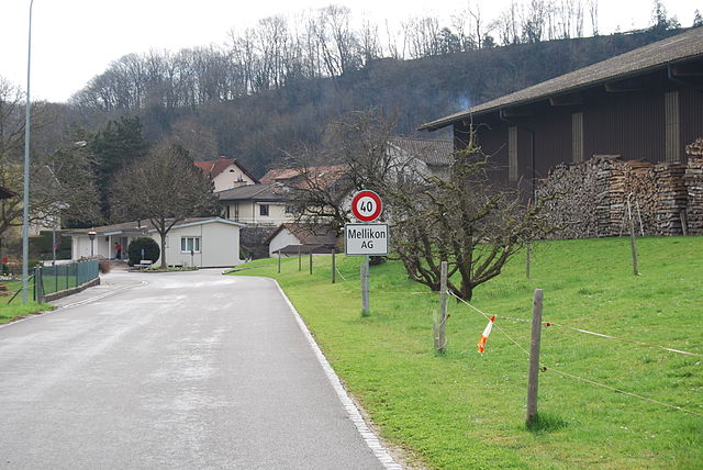

Mellikon
- municipality in Switzerland
Hiking in Mellikon
Mellikon, located in the captivating region of Switzerland, is a beautiful destination for hiking enthusiasts. This charming area offers a mix of scenic landscapes, well-marked trails, and the chance to explore picturesque villages and natural reserves....
- Country:
- Postal Code: 5465
- Local Dialing Code: 056
- Licence Plate Code: AG
- Coordinates: 47° 33' 48" N, 8° 20' 49" E
- GPS tracks (wikiloc): [Link]
- AboveSeaLevel: 399 м m
- Area: 2.70 sq km
- Population: 241
- Web site: [Link]


Full-Reuenthal
- municipality in Switzerland
Hiking in Full-Reuenthal
Full-Reuenthal, a quaint town in Switzerland, is surrounded by breathtaking natural landscapes that are perfect for hiking enthusiasts. The region boasts a variety of trails ranging from easy strolls to challenging hikes that offer stunning views of the Swiss Alps and picturesque countryside....
- Country:
- Postal Code: 5324
- Local Dialing Code: 056
- Licence Plate Code: AG
- Coordinates: 47° 36' 59" N, 8° 12' 20" E
- GPS tracks (wikiloc): [Link]
- AboveSeaLevel: 314 м m
- Area: 4.82 sq km
- Population: 879
- Web site: [Link]


Fisibach
- municipality in Switzerland
Hiking in Fisibach
Fisibach is located in the scenic region of the Swiss Alps, providing hikers with a multitude of beautiful trails and breathtaking views. Here are some key points to consider when planning a hike in Fisibach:...
- Country:
- Postal Code: 5467
- Local Dialing Code: 043
- Licence Plate Code: AG
- Coordinates: 47° 33' 49" N, 8° 24' 34" E
- GPS tracks (wikiloc): [Link]
- AboveSeaLevel: 422 м m
- Area: 5.77 sq km
- Population: 478
- Web site: [Link]


Leibstadt
- municipality in Switzerland
Hiking in Leibstadt
Leibstadt, located in Switzerland near the border with Germany, is a small yet picturesque village that offers beautiful hiking opportunities amidst stunning landscapes. Although it may not be as widely known as some of the larger Swiss hiking areas, it has its own charm and unique offerings for hikers....
- Country:
- Postal Code: 5325
- Local Dialing Code: 056
- Licence Plate Code: AG
- Coordinates: 47° 35' 23" N, 8° 10' 42" E
- GPS tracks (wikiloc): [Link]
- AboveSeaLevel: 339 м m
- Area: 6.39 sq km
- Population: 1289
- Web site: [Link]


Leuggern
- municipality in Switzerland
Hiking in Leuggern
Leuggern is a municipality in the Aargau canton of Switzerland. While it may not be widely recognized as a major hiking destination, the surrounding region offers various opportunities for outdoor activities, including hiking. Here are some points to consider when hiking in and around Leuggern:...
- Country:
- Postal Code: 5316
- Local Dialing Code: 056
- Licence Plate Code: AG
- Coordinates: 47° 34' 55" N, 8° 13' 10" E
- GPS tracks (wikiloc): [Link]
- AboveSeaLevel: 357 м m
- Area: 13.76 sq km
- Population: 2148
- Web site: [Link]
Rietheim
- municipality in the canton Aargau, Switzerland
Hiking in Rietheim
Rietheim, located in the Aargau region of Switzerland, is a charming area for hiking enthusiasts. The region features a mix of serene landscapes, rolling hills, and lush forests, offering a tranquil escape into nature....
- Country:
- Postal Code: 5323
- Local Dialing Code: 056
- Licence Plate Code: AG
- Coordinates: 47° 36' 10" N, 8° 16' 26" E
- GPS tracks (wikiloc): [Link]
- AboveSeaLevel: 333 м m
- Area: 3.92 sq km
- Population: 753
- Web site: [Link]

Kaiserstuhl
- municipality in the canton Aargau, Switzerland
Hiking in Kaiserstuhl
Kaiserstuhl, located in the Aargau region of Switzerland, is a beautiful area known for its rolling hills, vineyards, and scenic landscapes. The region provides an excellent backdrop for hiking enthusiasts of all levels....
- Country:
- Postal Code: 5466
- Local Dialing Code: 043
- Licence Plate Code: AG
- Coordinates: 47° 34' 7" N, 8° 25' 9" E
- GPS tracks (wikiloc): [Link]
- AboveSeaLevel: 341 м m
- Area: 0.32 sq km
- Population: 423
- Web site: [Link]


Klingnau
- municipality in Switzerland
Hiking in Klingnau
Klingnau is a charming town located in the canton of Aargau in Switzerland, nestled near the banks of the River Aare. The surrounding region is known for its picturesque landscapes and offers various hiking opportunities. Here are some highlights to consider when hiking in and around Klingnau:...
- Country:
- Postal Code: 5313
- Local Dialing Code: 056
- Licence Plate Code: AG
- Coordinates: 47° 34' 59" N, 8° 15' 0" E
- GPS tracks (wikiloc): [Link]
- AboveSeaLevel: 433 м m
- Area: 6.71 sq km
- Population: 3472
- Web site: [Link]
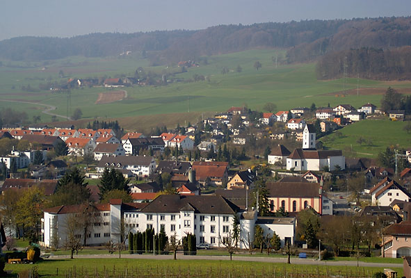

Lengnau
- municipality in the canton Aargau, Switzerland
Hiking in Lengnau
Lengnau is a charming village located in the Aargau region of Switzerland. It offers several opportunities for hiking, with routes that showcase the beautiful Swiss countryside, rolling hills, and scenic views. Here are some highlights and tips for hiking in and around Lengnau:...
- Country:
- Postal Code: 5426
- Local Dialing Code: 056
- Licence Plate Code: AG
- Coordinates: 47° 31' 20" N, 8° 19' 50" E
- GPS tracks (wikiloc): [Link]
- AboveSeaLevel: 410 м m
- Area: 12.67 sq km
- Population: 2743
- Web site: [Link]


Endingen
- municipality in Aargau, Switzerland
Hiking in Endingen
Endingen is a picturesque village located in the Canton of Aargau in Switzerland, surrounded by beautiful landscapes that offer excellent hiking opportunities. The area is characterized by its rolling hills, vineyards, and proximity to the Rhine River, making it a delightful destination for hikers of all levels....
- Country:
- Postal Code: 5304
- Local Dialing Code: 056
- Licence Plate Code: AG
- Coordinates: 47° 31' 51" N, 8° 17' 24" E
- GPS tracks (wikiloc): [Link]
- AboveSeaLevel: 488 м m
- Area: 11.92 sq km
- Population: 2574
- Web site: [Link]


Koblenz
- municipality in the canton of Aargau in Switzerland.
Hiking in Koblenz
Koblenz is actually a city in Germany at the confluence of the Rhine and Moselle rivers, and it seems there might be a mix-up regarding its location in Switzerland. However, if you're interested in hiking in the region around Koblenz, Germany, I can provide some insights!...
- Country:
- Postal Code: 5322
- Local Dialing Code: 056
- Licence Plate Code: AG
- Coordinates: 47° 36' 35" N, 8° 14' 14" E
- GPS tracks (wikiloc): [Link]
- AboveSeaLevel: 316 м m
- Area: 4.08 sq km
- Population: 1604
- Web site: [Link]