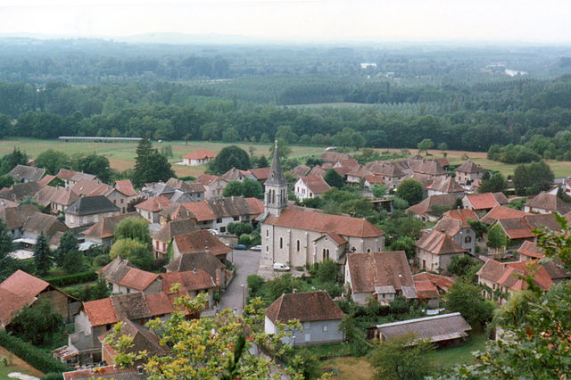
Аост (Aoste, Aoste)

 Hiking in Аост
Aoste, located in the Isère department of the Auvergne-Rhône-Alpes region in France, is a charming town surrounded by beautiful mountain landscapes, making it a great destination for hiking enthusiasts. The area offers a variety of hiking trails suitable for different skill levels, from leisurely walks to more challenging treks.
Popular Hiking Trails:
-
Vercors Regional Natural Park:
- Just a short drive from Aoste, the Vercors park offers stunning limestone cliffs, deep gorges, and lush forests. There are numerous trails, some leading to spectacular viewpoints like the Moucherotte peak.
- Trail suggestion: The hike to the Mont Aiguille is iconic and offers breathtaking vistas.
-
Chartreuse Mountains:
- South of Aoste lies the Chartreuse massif, which boasts serene landscapes and a network of hiking trails.
- Trail suggestion: The hike to the Chamechaude peak is a popular choice, rewarding hikers with panoramic views.
-
Local Trails:
- There are several well-marked paths near the town that showcase the stunning alpine flora and fauna. Look for trails that take you along scenic rivers and through quaint villages.
Tips for Hiking in Aoste:
- Season: The best time for hiking is during late spring to early autumn (May to September) when the weather is usually mild and the trails are more accessible.
- Preparation: Always check the weather conditions and trail information before setting out. Carry plenty of water, snacks, and a first aid kit.
- Guided Tours: If you prefer, consider joining local guided hikes that offer insight into the region’s natural and cultural history.
- Maps and Signage: Trails are typically well-marked, but having a detailed map (or GPS) can be helpful, especially on less traveled paths.
Near Aoste:
- Explore the local culture: When not hiking, take time to visit the town's historical sites, enjoy the local cuisine, or relax in the beautiful surroundings.
- Visit other nearby towns: Explore other charming towns in the Isère department, such as Grenoble or Bourgoin-Jallieu, for a broader experience of the region.
With its stunning scenery and diverse hiking options, Aoste is a fantastic base for both casual walkers and serious trekkers looking to experience the beauty of the French Alps. Enjoy your hiking adventures!
- Страна:

- Почтовый код: 38490
- Координаты: 45° 35' 18" N, 5° 36' 32" E


- GPS треки (wikiloc): [Ссылка]
- Площадь: 9.82 кв.км
- Население: 2862
- Веб сайт: http://www.mairie-aoste.fr
- Википедия русская: wiki(ru)
- Википедия английская: wiki(en)
- Википедия национальная: wiki(fr)
- Хранилище Wikidata: Wikidata: Q1008855
- Катеория в википедии: [Ссылка]
- код Freebase: [/m/03nw6sh]
- код Freebase: [/m/03nw6sh]
- код GeoNames: Альт: [3037393]
- код GeoNames: Альт: [3037393]
- номер SIREN: [213800121]
- номер SIREN: [213800121]
- код BNF: [15257841q]
- код BNF: [15257841q]
- код VIAF: Альт: [135309893]
- код VIAF: Альт: [135309893]
- код GND: Альт: [4295040-5]
- код GND: Альт: [4295040-5]
- код LCNAF: Альт: [nr93022338]
- код LCNAF: Альт: [nr93022338]
- код Цифрового атласа Римской империи: [7974]
- код Цифрового атласа Римской империи: [7974]
- код муниципалитета INSEE: 38012
- код муниципалитета INSEE: 38012
Граничит с регионами:


Романьё
- коммуна во Франции
Hiking in Романьё
Romagnieu is a charming commune located in the Isère department in the Auvergne-Rhône-Alpes region of southeastern France. It’s known for its natural beauty and proximity to hiking opportunities in the surrounding area, particularly due to its location near the Chartreuse Mountains and the Vercors Regional Natural Park....
- Страна:
- Почтовый код: 38480
- Координаты: 45° 34' 12" N, 5° 38' 29" E
- GPS треки (wikiloc): [Ссылка]
- Площадь: 17.11 кв.км
- Население: 1560
- Веб сайт: [Ссылка]


Граньё
- коммуна во Франции
Hiking in Граньё
Granieu is a charming village nestled in the picturesque French Alps, making it a fantastic destination for hiking enthusiasts. Its location offers access to a variety of trails that cater to different skill levels, from gentle walks to challenging ascents. Here are some highlights for hiking in the Granieu area:...
- Страна:
- Почтовый код: 38490
- Координаты: 45° 35' 58" N, 5° 35' 19" E
- GPS треки (wikiloc): [Ссылка]
- Площадь: 3.73 кв.км
- Население: 482
Бренье-Кордон
- коммуна во Франции
Hiking in Бренье-Кордон
Brégnier-Cordon is a charming village located in the Auvergne-Rhône-Alpes region of France, surrounded by stunning natural landscapes, making it an excellent destination for hiking enthusiasts. Here are some key points to consider when hiking in and around Brégnier-Cordon:...
- Страна:
- Почтовый код: 01300
- Координаты: 45° 38' 56" N, 5° 37' 11" E
- GPS треки (wikiloc): [Ссылка]
- Площадь: 11 кв.км
- Население: 856
- Веб сайт: [Ссылка]
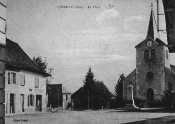

Шимьен
- коммуна во Франции
Hiking in Шимьен
Chimilin might refer to a specific region or area, but it doesn’t appear to be widely recognized as a hiking destination in available resources or discussions up to October 2023. However, if you are referring to a specific place known for hiking, such as Chimilin National Park or another similar-sounding location, please clarify....
- Страна:
- Почтовый код: 38490
- Координаты: 45° 34' 37" N, 5° 35' 58" E
- GPS треки (wikiloc): [Ссылка]
- Площадь: 9.66 кв.км
- Население: 1467
- Веб сайт: [Ссылка]


Saint-Genix-sur-Guiers
- коммуна во Франции
Hiking in Saint-Genix-sur-Guiers
Saint-Genix-sur-Guiers is a charming commune located in the Rhône-Alpes region of France, known for its beautiful scenery and access to hiking trails. Nestled at the foot of the Chartreuse Mountains, it offers a variety of outdoor activities, including hiking, with trails that cater to different skill levels....
- Страна:
- Почтовый код: 73240
- Координаты: 45° 36' 2" N, 5° 38' 4" E
- GPS треки (wikiloc): [Ссылка]
- Площадь: 12.27 кв.км
- Население: 2384