Аренто (Arinthod, Arinthod)

- коммуна во Франции
 Hiking in Аренто
Arinthod, located in the Jura department of France, offers a blend of natural beauty and diverse hiking opportunities. The region is characterized by its rolling hills, dense forests, and charming countryside. When hiking in and around Arinthod, you'll find a variety of trails that cater to different skill levels, from leisurely walks to more challenging hikes.
Highlights of Hiking in Arinthod:
-
Scenic Trails: The area features marked trails that lead through picturesque landscapes, with options to explore woodlands, hills, and panoramic viewpoints. The Jura Mountains provide a stunning backdrop, especially during sunrise and sunset.
-
Nature and Wildlife: As you hike, keep an eye out for local flora and fauna. The Jura region is known for its biodiversity, including various bird species, deer, and other wildlife. The serene atmosphere is perfect for nature enthusiasts and photographers.
-
Cultural Points of Interest: Along some trails, you might encounter historical landmarks, quaint villages, and traditional architecture that reflect the local culture. This adds an enriching element to your hike.
-
Accessibility: Many of the trails in the Arinthod area are accessible to families and casual hikers, while there are also more demanding routes for experienced trekkers looking for a challenge.
-
Seasonal Treasures: Each season offers a unique experience. Spring and summer bring lush greenery and blooming wildflowers, autumn showcases vibrant foliage, and winter can transform the landscape into a peaceful, snowy wonderland.
Hiking Tips:
- Trail Maps: Ensure you have updated trail maps, as they can help you navigate the area and discover new trails.
- Gear: Wear appropriate footwear and clothing suitable for the terrain and the weather.
- Hydration and Snacks: Carry enough water and energy-boosting snacks, especially for longer hikes.
- Respect Nature: Follow Leave No Trace principles to preserve the natural beauty of the area.
Whether you’re looking for a short walk or an extended hike, Arinthod and its surroundings provide an inviting environment for outdoor enthusiasts. Enjoy the adventure and embrace the tranquility of this picturesque part of France!
- Страна:

- Почтовый код: 39240
- Координаты: 46° 23' 35" N, 5° 34' 0" E


- GPS треки (wikiloc): [Ссылка]
- Площадь: 19.77 кв.км
- Население: 1092
- Веб сайт: http://www.mairiearinthod.fr
- Википедия английская: wiki(en)
- Википедия национальная: wiki(fr)
- Хранилище Wikidata: Wikidata: Q633372
- Катеория в википедии: [Ссылка]
- код Freebase: [/m/03mhrq8]
- код GeoNames: Альт: [6448764]
- номер SIREN: [213900160]
- код BNF: [152583825]
- ID отношения в OpenStreetMap: [7858560]
- код муниципалитета INSEE: 39016
Граничит с регионами:

Cernon
- коммуна во Франции
Hiking in Cernon
Cernon, located in the Jura mountain range of eastern France, offers a beautiful setting for hiking enthusiasts. The Jura is known for its stunning landscapes, rich biodiversity, and a variety of trails that cater to different levels of experience....
- Страна:
- Почтовый код: 39240
- Координаты: 46° 24' 11" N, 5° 38' 59" E
- GPS треки (wikiloc): [Ссылка]
- Площадь: 16.45 кв.км
- Население: 255


Cézia
- коммуна во Франции
Hiking in Cézia
As of my last update, there's no widely recognized location known as "Cézia" in hiking literature or guides. It’s possible that it could refer to a lesser-known area, a local nickname, or perhaps a typographical error. If you meant a specific region or park and can clarify or provide additional context, I would be more than happy to help!...
- Страна:
- Почтовый код: 39240
- Координаты: 46° 21' 37" N, 5° 34' 29" E
- GPS треки (wikiloc): [Ссылка]
- Площадь: 3.6 кв.км
- Население: 69


Légna
- коммуна во Франции
Hiking in Légna
Légna is a beautiful hiking destination, often known for its stunning landscapes and diverse trails. While exact details may depend on the specific region or country you are referring to, here are some general highlights of hiking in places like Légna:...
- Страна:
- Почтовый код: 39240
- Координаты: 46° 25' 37" N, 5° 35' 38" E
- GPS треки (wikiloc): [Ссылка]
- Площадь: 10.3 кв.км
- Население: 203


Vescles
- коммуна во Франции
Hiking in Vescles
It seems there might be a minor confusion regarding the location you're referring to as "Vescles." There isn't a well-known hiking area by that name. However, if you meant "Vesicles" or another location that sounds similar, please provide more context or check the spelling....
- Страна:
- Почтовый код: 39240
- Координаты: 46° 21' 37" N, 5° 36' 48" E
- GPS треки (wikiloc): [Ссылка]
- Площадь: 20.27 кв.км
- Население: 197

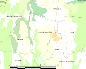
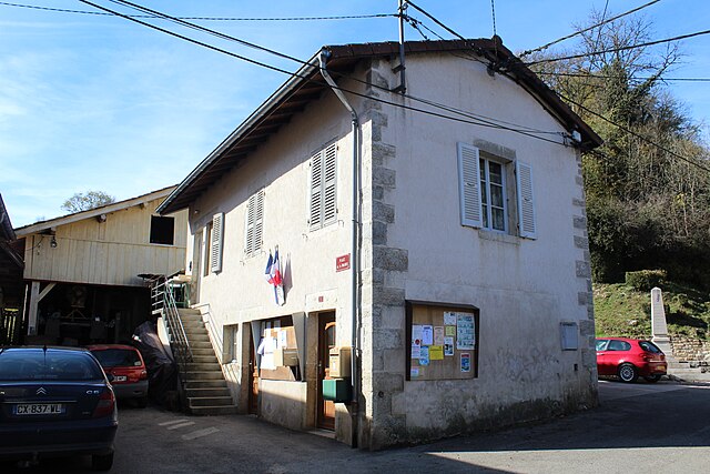
Saint-Hymetière
- коммуна во Франции
Hiking in Saint-Hymetière
Saint-Hymetière, located in France, offers a range of hiking opportunities that cater to different skill levels and preferences. The surrounding natural landscapes include lush forests, rolling hills, and panoramic views that are perfect for outdoor enthusiasts....
- Страна:
- Почтовый код: 39240
- Координаты: 46° 21' 32" N, 5° 33' 37" E
- GPS треки (wikiloc): [Ссылка]
- Площадь: 3.32 кв.км
- Население: 107

Valfin-sur-Valouse
- коммуна во Франции
Hiking in Valfin-sur-Valouse
Valfin-sur-Valouse is a charming village located in the Jura region of France, known for its stunning natural landscapes and outdoor activities, including hiking. The area features lush forests, rolling hills, and beautiful views of the surrounding countryside, making it an ideal destination for hikers of all skill levels....
- Страна:
- Почтовый код: 39240
- Координаты: 46° 22' 10" N, 5° 31' 10" E
- GPS треки (wikiloc): [Ссылка]
- Площадь: 8.67 кв.км
- Население: 82


Lavans-sur-Valouse
- коммуна во Франции
Hiking in Lavans-sur-Valouse
Lavans-sur-Valouse is a charming commune located in the Jura department of France. Nestled in the picturesque landscapes of the Jura Mountains, it offers a variety of hiking options that cater to different skill levels. Here's what you can expect when hiking in and around Lavans-sur-Valouse:...
- Страна:
- Почтовый код: 39240
- Координаты: 46° 20' 30" N, 5° 33' 53" E
- GPS треки (wikiloc): [Ссылка]
- Площадь: 9.51 кв.км
- Население: 146


Savigna
- коммуна во Франции
Hiking in Savigna
Savigna, although not widely recognized in popular hiking literature, could refer to a fictional location or a less-known area. However, if you're interested in hiking in a specific region with a similar name, such as Savigny, or if you're referring to a region in a country like Switzerland or France, I can provide general advice about hiking in European mountainous areas....
- Страна:
- Почтовый код: 39240
- Координаты: 46° 26' 26" N, 5° 34' 37" E
- GPS треки (wikiloc): [Ссылка]
- Площадь: 9.96 кв.км
- Население: 123


Dramelay
- коммуна во Франции
Hiking in Dramelay
Dramelay is a lesser-known hiking destination that offers beautiful trails and a chance to immerse yourself in nature. If you're planning to hike in this area, here are some things you should know:...
- Страна:
- Почтовый код: 39240
- Координаты: 46° 24' 24" N, 5° 32' 10" E
- GPS треки (wikiloc): [Ссылка]
- Площадь: 6.53 кв.км
- Население: 29


Chisséria
- коммуна во Франции
Hiking in Chisséria
Chisséria, often referred to as a hidden gem for outdoor enthusiasts, offers a variety of hiking trails that cater to different skill levels and provide stunning landscapes. While specific trail names and detailed mapping can vary, here are some general highlights and tips for hiking in the Chisséria region:...
- Страна:
- Почтовый код: 39240
- Координаты: 46° 22' 46" N, 5° 33' 47" E
- GPS треки (wikiloc): [Ссылка]
- Площадь: 7.25 кв.км
- Население: 72


Chatonnay
Hiking in Chatonnay
Chatonnay is a commune located in the Isère department in the Auvergne-Rhône-Alpes region of southeastern France. Although it may not be as well-known for hiking as some of its larger neighbors, it offers beautiful landscapes and a more rural experience for hikers looking to explore the region....
- Страна:
- Почтовый код: 39240
- Координаты: 46° 25' 29" N, 5° 32' 40" E
- GPS треки (wikiloc): [Ссылка]
- Площадь: 2.82 кв.км
- Население: 65