Шатонне (Châtonnay, Châtonnay)

- коммуна во Франции
 Hiking in Шатонне
Châtonnay is a charming village located in the Isère department of the Auvergne-Rhône-Alpes region in France, offering beautiful landscapes and a variety of hiking opportunities. While it may not be as well-known as some of the larger national parks or hiking destinations in France, the surrounding areas feature picturesque scenery, including rolling hills, forests, and valleys.
Hiking Trails
-
Local Trails: There are several marked trails around Châtonnay, often leading through scenic countryside and offering views of the surrounding mountains. Local maps may be available at the village or nearby tourist information centers.
-
Vercors Regional Natural Park: Located nearby, this park boasts stunning mountain scenery, diverse wildlife, and numerous trails for all skill levels. You can explore various routes that range from easy walks to more challenging hikes.
-
Forests and Rivers: Many trails may lead you through lush forests and along rivers, perfect for those who enjoy nature and tranquility. Look out for local flora and fauna, and be sure to bring your camera!
Recommendations
-
Best Time to Hike: Spring (April to June) and autumn (September to October) are ideal for hiking, with mild temperatures and beautiful landscapes. Summer can be quite warm, especially in lower elevations.
-
Gear: Make sure to wear appropriate hiking shoes, carry plenty of water, and bring sunscreen and a hat, especially during warmer months.
-
Guided Tours: If you're unfamiliar with the area or prefer a more structured experience, consider joining a guided hiking tour. Local guides can provide insights into the region’s history, ecology, and best spots.
-
Safety: Always inform someone about your hiking plans, carry a map, and imbibe by the principles of Leave No Trace to protect the natural beauty of the area.
Whether you're a seasoned hiker or a beginner looking to explore the outdoors, Châtonnay and its surroundings offer a wonderful opportunity to immerse yourself in nature. Enjoy your hiking adventure!
- Страна:

- Почтовый код: 38440
- Координаты: 45° 29' 9" N, 5° 12' 25" E


- GPS треки (wikiloc): [Ссылка]
- Площадь: 31.84 кв.км
- Население: 2070
- Веб сайт: http://chatonnay38.fr
- Википедия русская: wiki(ru)
- Википедия английская: wiki(en)
- Википедия национальная: wiki(fr)
- Хранилище Wikidata: Wikidata: Q574064
- Катеория в википедии: [Ссылка]
- код Freebase: [/m/03nvgsg]
- код GeoNames: Альт: [6448757]
- номер SIREN: [213800949]
- код BNF: [15257921c]
- код муниципалитета INSEE: 38094
Граничит с регионами:

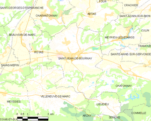
Сен-Жан-де-Бурне
- коммуна во Франции
Hiking in Сен-Жан-де-Бурне
Saint-Jean-de-Bournay is a charming commune located in the Isère department of the Auvergne-Rhône-Alpes region in southeastern France. The surrounding area is characterized by diverse landscapes, including low valleys, rolling hills, and scenic views, making it a great destination for hiking enthusiasts....
- Страна:
- Почтовый код: 38440
- Координаты: 45° 30' 8" N, 5° 8' 16" E
- GPS треки (wikiloc): [Ссылка]
- Площадь: 26.87 кв.км
- Население: 4622
- Веб сайт: [Ссылка]


Коммель
- коммуна во Франции
Hiking in Коммель
Commelle is a lesser-known hiking destination, but if you're referring to a specific region or trail system, I would need a bit more clarity, as there may be multiple locations with similar names around the world....
- Страна:
- Почтовый код: 38260
- Координаты: 45° 25' 41" N, 5° 13' 35" E
- GPS треки (wikiloc): [Ссылка]
- Площадь: 14.04 кв.км
- Население: 927
- Веб сайт: [Ссылка]


Семон
- коммуна во Франции
Hiking in Семон
It seems like there may be a slight misspelling or misunderstanding regarding the location "Semons." If you meant "Semon," "Semon Mountain," or perhaps a different location known for hiking (like the area around Semons or another name similar), please clarify....
- Страна:
- Почтовый код: 38260
- Координаты: 45° 25' 56" N, 5° 11' 41" E
- GPS треки (wikiloc): [Ссылка]
- Площадь: 10.55 кв.км
- Население: 362
- Веб сайт: [Ссылка]


Сент-Анн-сюр-Жервонд
- коммуна во Франции
Hiking in Сент-Анн-сюр-Жервонд
Sainte-Anne-sur-Gervonde, a picturesque municipality located in the Laurentian region of Quebec, Canada, offers several opportunities for hiking enthusiasts to explore its natural beauty. While there may not be established, well-known trails like those in larger parks, the area is characterized by its beautiful landscapes, forests, and lakes that can provide a range of outdoor experiences....
- Страна:
- Почтовый код: 38440
- Координаты: 45° 29' 59" N, 5° 14' 0" E
- GPS треки (wikiloc): [Ссылка]
- Площадь: 7.67 кв.км
- Население: 649
- Веб сайт: [Ссылка]


Нантуэн
- коммуна во Франции
Hiking in Нантуэн
Nantoin, a beautiful area often associated with the scenic landscapes of the Chartreuse National Park in France, is a fantastic destination for hiking enthusiasts. Here are some key points to consider if you're planning a hike in and around Nantoin:...
- Страна:
- Почтовый код: 38260
- Координаты: 45° 26' 8" N, 5° 16' 9" E
- GPS треки (wikiloc): [Ссылка]
- Высота над уровнем моря: 609 м m
- Площадь: 9.5 кв.км
- Население: 464
- Веб сайт: [Ссылка]
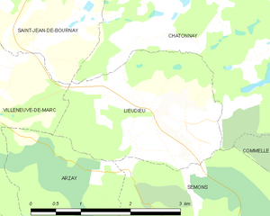
Льёдьё
- коммуна во Франции
Hiking in Льёдьё
Lieudieu is a scenic area located in the Auvergne-Rhône-Alpes region of France, nestled in the beautiful landscapes of the Alps. Hiking in this region can offer breathtaking views, diverse terrain, and opportunities to explore both nature and local culture....
- Страна:
- Почтовый код: 38440
- Координаты: 45° 27' 30" N, 5° 10' 53" E
- GPS треки (wikiloc): [Ссылка]
- Площадь: 5.94 кв.км
- Население: 341


Шампье
- коммуна во Франции
Hiking in Шампье
Champier is a charming village located in the Auvergne-Rhône-Alpes region of France, nestled near the northern edge of the Dauphiné region. While it might not be as famous as some larger locales, it offers a variety of beautiful hiking opportunities through picturesque landscapes that showcase the natural beauty of the area....
- Страна:
- Почтовый код: 38260
- Координаты: 45° 27' 12" N, 5° 17' 28" E
- GPS треки (wikiloc): [Ссылка]
- Площадь: 14.43 кв.км
- Население: 1387
- Веб сайт: [Ссылка]

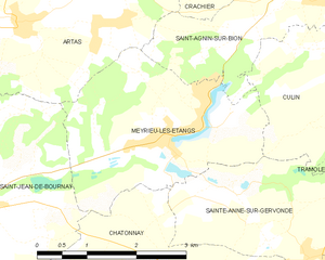
Мерье-лез-Этан
- коммуна во Франции
Hiking in Мерье-лез-Этан
Meyrieu-les-Étangs is a charming commune located in the Auvergne-Rhône-Alpes region of France. Nestled in a rural setting, it offers several opportunities for hiking enthusiasts to enjoy nature and exploration....
- Страна:
- Почтовый код: 38440
- Координаты: 45° 30' 49" N, 5° 12' 0" E
- GPS треки (wikiloc): [Ссылка]
- Высота над уровнем моря: 390 м m
- Площадь: 8.54 кв.км
- Население: 969
- Веб сайт: [Ссылка]