
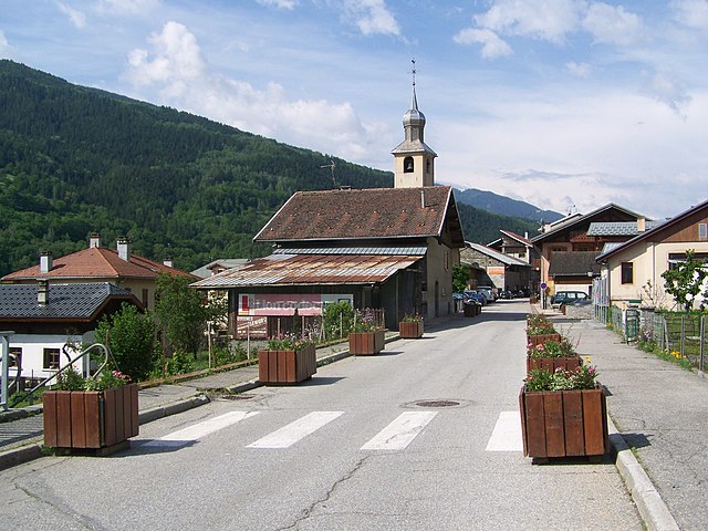
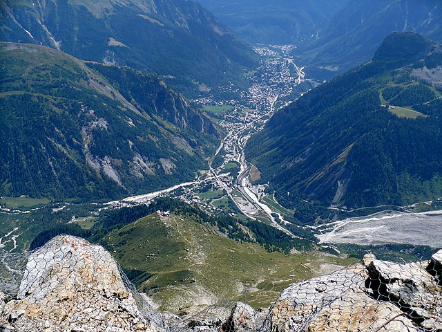
Бур-Сен-Морис (Bourg-Saint-Maurice, Bourg-Saint-Maurice)

- коммуна во Франции
 Hiking in Бур-Сен-Морис
Bourg-Saint-Maurice, located in the Savoie region of the French Alps, is a fantastic destination for hikers. It offers stunning alpine scenery, a variety of trails suitable for different skill levels, and access to some of the most beautiful landscapes in the region, including the Vanoise National Park.
Key Points for Hiking in Bourg-Saint-Maurice:
-
Scenic Trails:
- The area boasts numerous hiking trails that range from easy walks to challenging climbs. Popular routes include those leading to the Col de la Sassière and trails around the Les Arcs ski area.
- Trails vary in length, so hikers can choose routes that fit their physical abilities and experience level.
-
Vanoise National Park:
- This national park is nearby and offers a wealth of hiking opportunities. You can find well-marked trails that allow you to explore its rich biodiversity, including ibex and chamois.
- Don't miss the stunning views from various vantage points within the park.
-
Accessibility:
- Bourg-Saint-Maurice is well connected by public transport, making it easy for hikers to reach different trailheads.
- Many trailheads are accessible by road, and there are options for lifts (like gondolas) to help reach higher altitudes quickly.
-
Best Times to Hike:
- The hiking season typically runs from late spring to early autumn (May to October). The best chance for good weather and accessible trails is usually from June to September.
- Always check local weather conditions, as alpine weather can change rapidly.
-
Safety and Preparation:
- Always carry enough water, snacks, and a first-aid kit. Good hiking boots and clothing suited for sudden weather changes are crucial.
- Consider hiring a local guide if you’re unfamiliar with the area or if you plan to tackle more challenging routes.
-
Local Amenities:
- Bourg-Saint-Maurice has various accommodations, from hotels to chalets. There are also shops and restaurants where you can stock up on supplies or enjoy post-hike meals.
-
Cultural Sites:
- While hiking, take the time to enjoy local culture. The town has historical sites and charming architecture worth exploring.
Whether you're looking for a leisurely hike through scenic valleys or a challenging ascent to enjoy breathtaking alpine panoramas, Bourg-Saint-Maurice has something for every hiker. Happy hiking!
- Страна:

- Почтовый код: 73700
- Координаты: 45° 37' 0" N, 6° 46' 7" E


- GPS треки (wikiloc): [Ссылка]
- Высота над уровнем моря: 744 м m
- Площадь: 179.07 кв.км
- Население: 7228
- Веб сайт: http://www.ville-bourg-saint-maurice.fr
- Википедия русская: wiki(ru)
- Википедия английская: wiki(en)
- Википедия национальная: wiki(fr)
- Хранилище Wikidata: Wikidata: Q238039
- Катеория в википедии: [Ссылка]
- код Freebase: [/m/08pw9t]
- код GeoNames: Альт: [6450984]
- номер SIREN: [217300540]
- код BNF: [15273989f]
- код VIAF: Альт: [233850704]
- код GND: Альт: [4122959-9]
- идентификатор местоположения ArchINFORM: [42172]
- код LCNAF: Альт: [n85068802]
- код тезауруса PACTOLS: [pcrtVFmHqgyfo5]
- код Цифрового атласа Римской империи: [7983]
- код муниципалитета INSEE: 73054
Граничит с регионами:


Beaufort
Hiking in Beaufort
Beaufort, located in the Savoie region of the French Alps, offers a stunning backdrop for hiking enthusiasts. Known for its picturesque alpine landscapes, the area is characterized by rolling hills, lush meadows, and rugged mountain terrain. Here are some highlights and tips for hiking in Beaufort:...
- Страна:
- Почтовый код: 73270
- Координаты: 45° 43' 5" N, 6° 34' 30" E
- GPS треки (wikiloc): [Ссылка]
- Площадь: 149.53 кв.км
- Население: 2088

Bellentre
- коммуна во Франции
Hiking in Bellentre
Bellentre is a charming commune located in the Savoie department of the Auvergne-Rhône-Alpes region in southeastern France. It’s situated in the heart of the French Alps, making it a fantastic destination for hiking enthusiasts. Here are some key aspects to consider when hiking in Bellentre:...
- Страна:
- Почтовый код: 73210
- Координаты: 45° 34' 10" N, 6° 42' 50" E
- GPS треки (wikiloc): [Ссылка]
- Площадь: 23.94 кв.км
- Население: 924


Villaroger
- коммуна во Франции
Hiking in Villaroger
Villaroger is a charming village located in the French Alps, within the Tarentaise Valley in the Savoie region. It offers a range of hiking opportunities, making it an attractive destination for outdoor enthusiasts. Here are some key points to consider when hiking in Villaroger:...
- Страна:
- Почтовый код: 73640
- Координаты: 45° 35' 28" N, 6° 52' 28" E
- GPS треки (wikiloc): [Ссылка]
- Площадь: 28.15 кв.км
- Население: 387

Курмайёр
- коммуна Италии
Hiking in Курмайёр
Courmayeur, located in the Aosta Valley of Italy, is a fantastic destination for hikers. Nestled at the foot of Mont Blanc, the area offers a variety of trails that cater to all skill levels, from leisurely walks to challenging alpine hikes. Here are some highlights for hiking in Courmayeur:...
- Страна:

- Почтовый код: 11013
- Телефонный код: 0165
- Код автомобильного номера: AO
- Координаты: 45° 47' 0" N, 6° 58' 0" E
- GPS треки (wikiloc): [Ссылка]
- Высота над уровнем моря: 1224 м m
- Площадь: 210 кв.км
- Население: 2798
- Веб сайт: [Ссылка]


Ла-Тюйль
- коммуна Италии
Hiking in Ла-Тюйль
La Thuile, located in the Aosta Valley region of Italy, is a fantastic destination for hiking enthusiasts. Nestled in the Alps, this area offers stunning landscapes, diverse wildlife, and a variety of hiking trails suitable for all skill levels, from beginners to experienced adventurers....
- Страна:
- Почтовый код: 11016
- Телефонный код: 0165
- Код автомобильного номера: AO
- Координаты: 45° 42' 58" N, 6° 57' 0" E
- GPS треки (wikiloc): [Ссылка]
- Высота над уровнем моря: 1450 м m
- Площадь: 125.67 кв.км
- Население: 783
- Веб сайт: [Ссылка]

Les Contamines-Montjoie
- коммуна во Франции
Hiking in Les Contamines-Montjoie
Les Contamines-Montjoie is a beautiful alpine village located in the French Alps, known for its stunning mountain scenery, diverse trails, and rich natural environment. Here’s an overview of what you can expect when hiking in this region:...
- Страна:
- Почтовый код: 74170
- Координаты: 45° 49' 18" N, 6° 43' 45" E
- GPS треки (wikiloc): [Ссылка]
- Площадь: 81.35 кв.км
- Население: 1196
- Веб сайт: [Ссылка]
Landry, Savoie
- коммуна во Франции
Hiking in Landry, Savoie
Landry, located in the Savoie region of the French Alps, is an excellent destination for hiking enthusiasts. The area is known for its stunning natural landscapes, characterized by majestic mountains, lush valleys, and diverse wildlife. Here are some key points about hiking in Landry:...
- Страна:
- Почтовый код: 73210
- Координаты: 45° 34' 16" N, 6° 44' 26" E
- GPS треки (wikiloc): [Ссылка]
- Площадь: 10.62 кв.км
- Население: 843
- Веб сайт: [Ссылка]


Peisey-Nancroix
- коммуна во Франции
Hiking in Peisey-Nancroix
Peisey-Nancroix is a beautiful alpine village located in the Tarentaise Valley in the Savoie region of the French Alps. It serves as a gateway to some stunning hiking trails, particularly within the Vanoise National Park, which is famous for its diverse landscapes, wildlife, and breathtaking views. Here are some highlights and tips for hiking in the Peisey-Nancroix area:...
- Страна:
- Почтовый код: 73210
- Координаты: 45° 32' 47" N, 6° 45' 23" E
- GPS треки (wikiloc): [Ссылка]
- Площадь: 70.64 кв.км
- Население: 640


Les Chapelles
- коммуна во Франции
Hiking in Les Chapelles
Les Chapelles is a picturesque area, often associated with beautiful landscapes and varied hiking opportunities. While it might not be a well-known name compared to other hiking destinations, the region boasts charming trails that reflect the natural beauty and cultural heritage of the surrounding areas....
- Страна:
- Почтовый код: 73700
- Координаты: 45° 35' 24" N, 6° 43' 47" E
- GPS треки (wikiloc): [Ссылка]
- Площадь: 17.31 кв.км
- Население: 556

Séez
- коммуна во Франции
Hiking in Séez
Séez, located in the Auvergne-Rhône-Alpes region of France near the Italian border, is a gateway to some beautiful hiking experiences in the the French Alps. Here’s what you need to know about hiking in and around Séez:...
- Страна:
- Почтовый код: 73700
- Координаты: 45° 37' 22" N, 6° 48' 3" E
- GPS треки (wikiloc): [Ссылка]
- Площадь: 42.55 кв.км
- Население: 2398
- Веб сайт: [Ссылка]