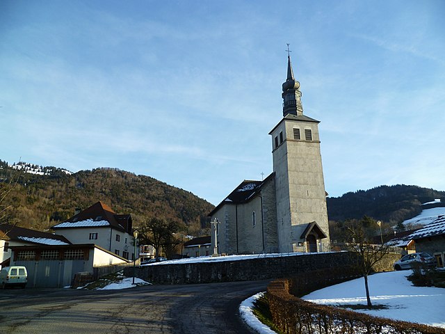
Boëge (Boëge)

- коммуна во Франции
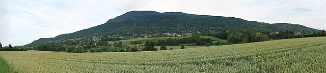
 Hiking in Boëge
Boëge is a charming commune located in the Haute-Savoie region of the French Alps, offering beautiful landscapes and a variety of hiking options. The area is characterized by its picturesque mountain views, lush forests, and tranquil lakes, making it a fantastic destination for outdoor enthusiasts.
Hiking Trails
-
Lac de Maîche: This is a popular hike that leads you to a serene lake. The trail offers a good mix of elevation and flat sections, suitable for families and casual hikers. The path meanders through beautiful forests and gives you lovely views of the surrounding mountains.
-
Sentier du Petit Mont: This trail offers a moderate challenge with rewarding panoramic views at the summit. It’s a great option for those looking for a bit of a workout and wanting to enjoy some breathtaking scenery.
-
Col de la Joux Verte: For more experienced hikers, the trail to the Col de la Joux Verte offers a more demanding trek that winds through alpine meadows and rocky terrain. The views from the top are spectacular, often featuring Mont Blanc on clear days.
Tips for Hiking in Boëge
- Seasonal Considerations: The best times to hike in Boëge are late spring through early fall, as winter trails may be snow-covered and inaccessible.
- Safety and Preparation: Always check the weather forecast before embarking on a hike, and ensure that you have suitable gear, including sturdy footwear, water, snacks, and appropriate clothing for sudden weather changes.
- Local Regulations: Respect the natural environment and adhere to local guidelines and regulations, especially regarding wildlife and trail maintenance.
Additional Activities
Apart from hiking, Boëge offers opportunities for mountain biking, fishing, and enjoying the local cuisine in nearby villages. The area's rich history can also be explored through local cultural sites.
Overall, hiking in Boëge provides a refreshing escape into nature, perfect for anyone looking to experience the beauty of the French Alps.
- Страна:

- Почтовый код: 74420
- Координаты: 46° 12' 32" N, 6° 24' 17" E


- GPS треки (wikiloc): [Ссылка]
- Площадь: 16 кв.км
- Население: 1672
- Википедия английская: wiki(en)
- Википедия национальная: wiki(fr)
- Хранилище Wikidata: Wikidata: Q654167
- Катеория в википедии: [Ссылка]
- код Freebase: [/m/03ntx_8]
- код GeoNames: Альт: [6455255]
- номер SIREN: [217400373]
- код BNF: [15274297c]
- код VIAF: Альт: [234364325]
- WOEID: [580310]
- код муниципалитета INSEE: 74037
Граничит с регионами:
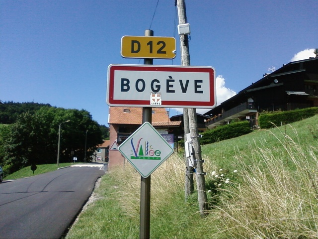

Bogève
- коммуна во Франции
Hiking in Bogève
Bogève, a picturesque village located in the Haute-Savoie region of France, offers stunning hiking opportunities amidst the French Alps. The area is known for its rich natural beauty, characterized by rolling hills, lush forests, and breathtaking mountain views....
- Страна:
- Почтовый код: 74250
- Координаты: 46° 11' 33" N, 6° 25' 47" E
- GPS треки (wikiloc): [Ссылка]
- Площадь: 7 кв.км
- Население: 1046


Cranves-Sales
- коммуна во Франции
Hiking in Cranves-Sales
Cranves-Sales, located in the Haute-Savoie region of France, is a scenic destination that offers beautiful landscapes and various hiking opportunities. Nestled near the Alps and close to Lake Geneva, the area is characterized by its rolling hills, forests, and stunning views of the surrounding mountains....
- Страна:
- Почтовый код: 74380
- Координаты: 46° 11' 12" N, 6° 17' 29" E
- GPS треки (wikiloc): [Ссылка]
- Площадь: 13.61 кв.км
- Население: 6562
- Веб сайт: [Ссылка]

Villard, Haute-Savoie
- коммуна во Франции
Hiking in Villard, Haute-Savoie
Villard in Haute-Savoie is a fantastic destination for hiking enthusiasts, set in the stunning French Alps. The region offers a variety of trails that cater to all levels of hikers, from beginners to experienced trekkers. Here are some key points about hiking in Villard:...
- Страна:
- Почтовый код: 74420
- Координаты: 46° 13' 1" N, 6° 26' 27" E
- GPS треки (wikiloc): [Ссылка]
- Площадь: 7.42 кв.км
- Население: 760

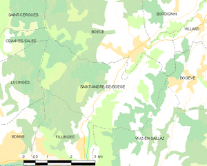
Saint-André-de-Boëge
- коммуна во Франции
Hiking in Saint-André-de-Boëge
Saint-André-de-Boëge is a charming commune located in the Haute-Savoie department in the Auvergne-Rhône-Alpes region of southeastern France. It's nestled within the scenic backdrop of the French Alps, making it an appealing destination for outdoor enthusiasts and hikers....
- Страна:
- Почтовый код: 74420
- Координаты: 46° 11' 25" N, 6° 23' 37" E
- GPS треки (wikiloc): [Ссылка]
- Площадь: 12.6 кв.км
- Население: 549


Burdignin
- коммуна во Франции
Hiking in Burdignin
Burdignin, a picturesque village located in the Haute-Savoie region of France, offers a charming experience for hiking enthusiasts. Nestled in the stunning French Alps, it serves as an excellent base for exploring the surrounding natural beauty....
- Страна:
- Почтовый код: 74420
- Координаты: 46° 13' 16" N, 6° 25' 26" E
- GPS треки (wikiloc): [Ссылка]
- Площадь: 9.87 кв.км
- Население: 610
- Веб сайт: [Ссылка]
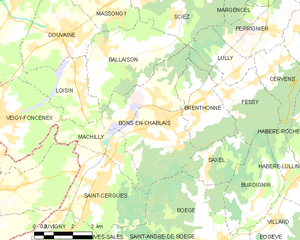
Bons-en-Chablais
- коммуна во Франции
Hiking in Bons-en-Chablais
Bons-en-Chablais is a charming commune located in the Haute-Savoie region of the French Alps. Its proximity to both the mountains and Lake Geneva makes it an excellent location for hiking enthusiasts. Here are some highlights and tips for hiking in the area:...
- Страна:
- Почтовый код: 74890
- Координаты: 46° 15' 52" N, 6° 22' 13" E
- GPS треки (wikiloc): [Ссылка]
- Площадь: 19.09 кв.км
- Население: 5456
- Веб сайт: [Ссылка]

Saint-Cergues
- коммуна во Франции
Hiking in Saint-Cergues
Saint-Cergues is a picturesque commune located near the French-Swiss border, not far from Lake Geneva and the city of Geneva itself. The area is known for its stunning natural beauty and offers a variety of hiking opportunities for outdoor enthusiasts of all skill levels. Here are some highlights about hiking in Saint-Cergues:...
- Страна:
- Почтовый код: 74140
- Координаты: 46° 14' 9" N, 6° 19' 17" E
- GPS треки (wikiloc): [Ссылка]
- Площадь: 12.55 кв.км
- Население: 3571
Saxel
- коммуна во Франции
Hiking in Saxel
Saxel is a picturesque village located in the Haute-Savoie region of France, near Lake Geneva, and is known for its stunning landscapes and outdoor activities, including hiking. The surrounding area offers numerous trails that cater to various skill levels, making it a great destination for hikers of all abilities....
- Страна:
- Почтовый код: 74420
- Координаты: 46° 14' 35" N, 6° 23' 43" E
- GPS треки (wikiloc): [Ссылка]
- Площадь: 5.63 кв.км
- Население: 460