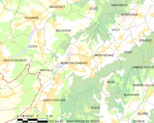
Saint-Cergues (Saint-Cergues)

- коммуна во Франции
 Hiking in Saint-Cergues
Saint-Cergues is a picturesque commune located near the French-Swiss border, not far from Lake Geneva and the city of Geneva itself. The area is known for its stunning natural beauty and offers a variety of hiking opportunities for outdoor enthusiasts of all skill levels. Here are some highlights about hiking in Saint-Cergues:
Scenic Trails
-
Varied Terrain: The hiking trails in and around Saint-Cergues feature a mix of terrains, including forest paths, alpine meadows, and scenic viewpoints overlooking the surrounding mountains and the Rhône Valley.
-
Views: Many hikes offer breathtaking panoramic views of Mont Blanc, the Alps, and Lake Geneva, making it a rewarding destination for photography and nature lovers.
Popular Hikes
-
Les Voirons Range: This nearby mountain range has several hiking trails that lead you through beautiful nature and offer various levels of difficulty. The paths often lead to stunning viewpoints.
-
Circuits for Families and Beginners: There are accessible trails suitable for families or novice hikers. These paths often provide educational signs about local flora and fauna.
-
Chalet des Ciernes: A moderate hike leading to a charming chalet where hikers can rest and enjoy the local cuisine.
Hiking Tips
-
Season: The best time to hike in the region is during the spring to early autumn (April to October) when the weather is typically milder and the trails are more accessible.
-
Safety: Always check the weather conditions before heading out, as conditions can change rapidly in mountainous areas. Carry sufficient water, snacks, and a map or GPS device.
-
Local Guides: If you're unfamiliar with the area, consider hiring a local guide to enhance your understanding of the trail and its features.
Accessibility
Saint-Cergues is easily accessible from Geneva and other nearby towns, making it a popular destination for both locals and tourists looking for a day hike or a weekend adventure.
Amenities
After a day of hiking, you can find local restaurants and cafés in Saint-Cergues where you can enjoy regional dishes and refreshments.
In summary, hiking in Saint-Cergues offers an excellent opportunity to explore stunning landscapes, enjoy fresh air, and experience the outdoors in a serene environment. Whether you're new to hiking or an experienced trekker, there's something for everyone in this charming part of the Alps!
- Страна:

- Почтовый код: 74140
- Координаты: 46° 14' 9" N, 6° 19' 17" E


- GPS треки (wikiloc): [Ссылка]
- Площадь: 12.55 кв.км
- Население: 3571
- Википедия английская: wiki(en)
- Википедия национальная: wiki(fr)
- Хранилище Wikidata: Wikidata: Q769096
- Катеория в википедии: [Ссылка]
- код Freebase: [/m/03ntz6g]
- код GeoNames: Альт: [6443032]
- номер SIREN: [217402296]
- код BNF: [15274485x]
- код тезауруса PACTOLS: [pcrtI5LsbziNRs]
- код муниципалитета INSEE: 74229
Граничит с регионами:


Cranves-Sales
- коммуна во Франции
Hiking in Cranves-Sales
Cranves-Sales, located in the Haute-Savoie region of France, is a scenic destination that offers beautiful landscapes and various hiking opportunities. Nestled near the Alps and close to Lake Geneva, the area is characterized by its rolling hills, forests, and stunning views of the surrounding mountains....
- Страна:
- Почтовый код: 74380
- Координаты: 46° 11' 12" N, 6° 17' 29" E
- GPS треки (wikiloc): [Ссылка]
- Площадь: 13.61 кв.км
- Население: 6562
- Веб сайт: [Ссылка]


Boëge
- коммуна во Франции
Hiking in Boëge
Boëge is a charming commune located in the Haute-Savoie region of the French Alps, offering beautiful landscapes and a variety of hiking options. The area is characterized by its picturesque mountain views, lush forests, and tranquil lakes, making it a fantastic destination for outdoor enthusiasts....
- Страна:
- Почтовый код: 74420
- Координаты: 46° 12' 32" N, 6° 24' 17" E
- GPS треки (wikiloc): [Ссылка]
- Площадь: 16 кв.км
- Население: 1672
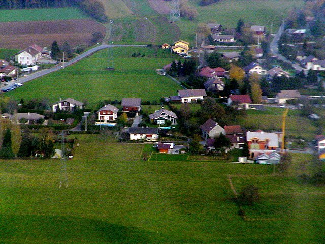
Bons-en-Chablais
- коммуна во Франции
Hiking in Bons-en-Chablais
Bons-en-Chablais is a charming commune located in the Haute-Savoie region of the French Alps. Its proximity to both the mountains and Lake Geneva makes it an excellent location for hiking enthusiasts. Here are some highlights and tips for hiking in the area:...
- Страна:
- Почтовый код: 74890
- Координаты: 46° 15' 52" N, 6° 22' 13" E
- GPS треки (wikiloc): [Ссылка]
- Площадь: 19.09 кв.км
- Население: 5456
- Веб сайт: [Ссылка]

Juvigny, Haute-Savoie
Hiking in Juvigny, Haute-Savoie
Juvigny, located in the Haute-Savoie region of the French Alps, is a picturesque village that offers a variety of hiking opportunities for all skill levels. The region is known for its stunning mountain landscapes, lush forests, and sweeping alpine views....
- Страна:
- Почтовый код: 74100
- Координаты: 46° 12' 52" N, 6° 16' 51" E
- GPS треки (wikiloc): [Ссылка]
- Площадь: 2.71 кв.км
- Население: 650


Machilly
- коммуна во Франции
Hiking in Machilly
Machilly is a charming commune located in the Haute-Savoie region of France, near the French-Swiss border. While it may not be as widely known as some of the larger hiking destinations in the Alps, it offers a great opportunity for outdoor enthusiasts to explore beautiful landscapes, forests, and potentially less crowded trails....
- Страна:
- Почтовый код: 74140
- Координаты: 46° 15' 6" N, 6° 19' 53" E
- GPS треки (wikiloc): [Ссылка]
- Площадь: 5.76 кв.км
- Население: 1075
- Веб сайт: [Ссылка]