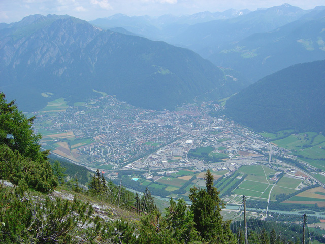
Доссо-дель-Лиро (Dosso del Liro, Dosso del Liro)
.svg)
- коммуна Италии
 Hiking in Доссо-дель-Лиро
Dosso del Liro is a beautiful destination for hiking enthusiasts, located in the northern part of Italy, close to the shores of Lake Como in the Lombardy region. The area is characterized by its picturesque landscapes, lush greenery, and stunning views of the surrounding mountains and valleys. Here are some key points to consider when planning a hiking trip to Dosso del Liro:
Trails and Routes
- Variety of Trails: Dosso del Liro offers a range of hiking trails suited for different skill levels, from easy walks suitable for families to challenging routes for experienced hikers.
- Scenic Views: Many trails provide breathtaking views of Lake Como, the surrounding valleys, and the peaks of the Alps. Look for vantage points along the routes where you can stop and take in the scenery.
- Flora and Fauna: The area is rich in biodiversity, with many species of plants and wildlife. Keep an eye out for local flora, particularly during the spring and summer months when wildflowers are in bloom.
Access and Logistics
- Getting There: Dosso del Liro is accessible by car or public transport. Nearby towns like Menaggio or Dongo can serve as good access points. Make sure to check local transport schedules if you are taking public transport.
- Seasonal Considerations: The best time for hiking here is typically from late spring to early autumn (May to October), when the weather is mild and the trails are clear of snow.
- Preparation: As with any hiking excursion, be sure to prepare adequately. Bring sufficient water, snacks, and a map or GPS device. It's wise to wear sturdy hiking boots and consider weather conditions.
Local Highlights
- Cultural Features: In addition to hiking, explore the local culture. The area has charming villages and historical sites that reflect the region's history and traditions.
- Cuisine: After a day of hiking, enjoy local Italian cuisine at the nearby restaurants. Freshwater fish from Lake Como and regional pastas are highly recommended.
Safety Considerations
- Trail Conditions: Always check trail conditions before heading out, as weather can change quickly in mountainous regions.
- Inform Someone: It’s often a good practice to inform someone of your hiking plans. Whether it's a friend or family member, letting someone know your intended route can ensure safety.
- Equipment Check: Ensure you have appropriate gear for your hike, including a first-aid kit, navigation tools, and layers for variable weather conditions.
Conclusion
Hiking in Dosso del Liro can provide a unique and rewarding outdoor experience, mixing the tranquility of nature with the charm of Italian culture. Whether you're looking for a peaceful stroll or an adventurous trek, this area has much to offer. Enjoy your hike!
- Страна:

- Почтовый код: 22015
- Телефонный код: 0344
- Код автомобильного номера: CO
- Координаты: 46° 10' 0" N, 9° 16' 0" E


- GPS треки (wikiloc): [Ссылка]
- Высота над уровнем моря: 650 м m
- Площадь: 23.49 кв.км
- Население: 262
- Веб сайт: http://www.comune.dossodelliro.co.it/
- Википедия русская: wiki(ru)
- Википедия английская: wiki(en)
- Википедия национальная: wiki(it)
- Хранилище Wikidata: Wikidata: Q47635
- Катеория в википедии: [Ссылка]
- код Freebase: [/m/0gj00n]
- код GeoNames: Альт: [6543109]
- код VIAF: Альт: [234357787]
- ID отношения в OpenStreetMap: [46961]
- код ISTAT: 013092
- кадастровый код Италии: D355
Граничит с регионами:
Граубюнден
- кантон в Швейцарии
Hiking in Граубюнден
The Canton of Grisons, or Graubünden, is a breathtaking region in Switzerland known for its stunning landscapes, diverse hiking trails, and rich cultural heritage. Here are some highlights of hiking in this beautiful area:...
- Страна:

- Столица: Кур
- Код автомобильного номера: GR
- Координаты: 46° 45' 0" N, 9° 30' 0" E
- GPS треки (wikiloc): [Ссылка]
- Высота над уровнем моря: 585 м m
- Площадь: 7105.39 кв.км
- Веб сайт: [Ссылка]
Пельо
- коммуна в провинции Комо, Италия
Hiking in Пельо
Peglio, located in the province of Como in the Lombardy region of Italy, is a charming village surrounded by impressive natural landscapes, making it an excellent destination for hiking enthusiasts. The area is characterized by rolling hills, lush forests, and scenic views of the surrounding mountains and Lake Como....
- Страна:
- Почтовый код: 22010
- Телефонный код: 0344
- Код автомобильного номера: CO
- Координаты: 46° 9' 0" N, 9° 17' 0" E
- GPS треки (wikiloc): [Ссылка]
- Высота над уровнем моря: 650 м m
- Площадь: 10.57 кв.км
- Население: 186
- Веб сайт: [Ссылка]

Gravedona ed Uniti
- коммуна Италии
Hiking in Gravedona ed Uniti
Gravedona ed Uniti is a charming town located on the northern shores of Lake Como in Italy, known for its beautiful landscapes and rich history. Hiking in this area offers a variety of trails that cater to different skill levels, providing stunning views of the lake, surrounding mountains, and picturesque villages....
- Страна:
- Почтовый код: 22015
- Телефонный код: 0344
- Код автомобильного номера: CO
- Координаты: 46° 9' 0" N, 9° 18' 0" E
- GPS треки (wikiloc): [Ссылка]
- Высота над уровнем моря: 201 м m
- Площадь: 39.85 кв.км
- Население: 4198
- Веб сайт: [Ссылка]
Ливо
- коммуна в провинции Комо, Италия
Hiking in Ливо
Livo is a picturesque village located in the province of Sondrio in Lombardy, Italy. It is situated in the northern part of the region, close to the shores of Lake Como, and is surrounded by beautiful mountains and lush landscapes. Hiking in Livo offers various trails that cater to different skill levels, making it an excellent destination for both novice and experienced hikers....
- Страна:
- Почтовый код: 22010
- Телефонный код: 0344
- Код автомобильного номера: CO
- Координаты: 46° 10' 0" N, 9° 18' 0" E
- GPS треки (wikiloc): [Ссылка]
- Высота над уровнем моря: 675 м m
- Площадь: 33.13 кв.км
- Население: 171
- Веб сайт: [Ссылка]


Ровередо
Hiking in Ровередо
Roveredo is a quaint town located in the Mendrisiotto region of Ticino, Switzerland. Surrounded by stunning natural landscapes, it offers several hiking opportunities that cater to a variety of skill levels. Here are some highlights of hiking in Roveredo:...
- Страна:
- Почтовый код: 6535
- Телефонный код: 091
- Код автомобильного номера: GR
- Координаты: 46° 14' 5" N, 9° 7' 33" E
- GPS треки (wikiloc): [Ссылка]
- Высота над уровнем моря: 1239 м m
- Площадь: 38.79 кв.км
- Население: 2483
- Веб сайт: [Ссылка]


Кама
- муниципалитет в Швейцарии
Hiking in Кама
Cama, located in the picturesque Graubünden region of Switzerland, offers some stunning hiking opportunities. This small village, nestled in the valley near the Albula River, is surrounded by beautiful alpine scenery, making it a great destination for both day hikes and more extended trekking adventures....
- Страна:
- Почтовый код: 6557
- Телефонный код: 091
- Код автомобильного номера: GR
- Координаты: 46° 15' 35" N, 9° 12' 27" E
- GPS треки (wikiloc): [Ссылка]
- Высота над уровнем моря: 1598 м m
- Площадь: 15.0 кв.км
- Население: 564
- Веб сайт: [Ссылка]


Гроно
Hiking in Гроно
Grono, a charming village located in the canton of Grisons (Graubünden) in Switzerland, offers stunning landscapes and a variety of hiking opportunities. The area is characterized by picturesque views of the surrounding mountains, lush valleys, and the serene atmosphere of the Swiss Alps....
- Страна:
- Почтовый код: 6537
- Телефонный код: 091
- Код автомобильного номера: GR
- Координаты: 46° 14' 54" N, 9° 8' 52" E
- GPS треки (wikiloc): [Ссылка]
- Высота над уровнем моря: 1073 м m
- Площадь: 14.81 кв.км
- Население: 1373
- Веб сайт: [Ссылка]