canton of Beaurepaire (canton de Beaurepaire)
 Hiking in canton of Beaurepaire
Canton de Beaurepaire, located in the Isère department in the Auvergne-Rhône-Alpes region of France, is a wonderful destination for hiking enthusiasts. This area boasts stunning natural landscapes, charming villages, and a rich cultural heritage, making it a great spot for outdoor adventures.
Hiking Highlights:
-
Scenic Trails: The region offers a variety of hiking trails ranging from easy walks to more challenging hikes. The trails often lead through beautiful countryside, forests, and hills, offering picturesque views of the surrounding landscape.
-
Diverse Flora and Fauna: As you hike, you'll likely encounter a diverse range of plant species and wildlife. The region is known for its rich biodiversity, which is especially vibrant in the warmer months.
-
Historic Sites: Along some hiking routes, you may come across historic sites, including old churches, ruins, and traditional farms. These provide a glimpse into the local history and culture.
-
Local Gastronomy: After a day of hiking, you can enjoy the local cuisine in the nearby villages. Look out for local specialties, such as cheeses and wines, to replenish your energy.
-
Accessibility: The Canton de Beaurepaire is accessible from major towns and cities in the region, making it convenient for day trips or longer stays.
Tips for Hiking in Canton de Beaurepaire:
-
Check Trail Maps: Before heading out, consult a local trail map or app to help navigate the best routes based on your skill level and preferences.
-
Weather Preparedness: The weather can change quickly in the mountains, so pack layers and be prepared for different conditions, including rain.
-
Stay Hydrated and Nourished: Bring enough water and snacks to maintain your energy levels, especially on longer hikes.
-
Respect Nature: Follow Leave No Trace principles; stay on marked trails, pack out what you pack in, and be considerate of wildlife.
-
Local Guides: If you're unfamiliar with the area or prefer a structured experience, consider hiring a local guide who can provide insights and ensure your safety.
Whether you're looking for a leisurely walk or a more challenging trek, Canton de Beaurepaire offers a variety of options that showcase the stunning beauty of the French countryside. Enjoy your hiking adventure!
- Страна:

- Столица: Борепер
- Координаты: 45° 23' 35" N, 5° 0' 53" E


- GPS треки (wikiloc): [Ссылка]
- Хранилище Wikidata: Wikidata: Q659726
- код кантона INSEE: [3802]
Включает регионы:

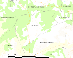
Шалон
- коммуна во Франции
Hiking in Шалон
Chalon, located in the Isère department of the Auvergne-Rhône-Alpes region in southeastern France, is surrounded by beautiful natural landscapes that offer various hiking opportunities. Here are some highlights of hiking in the area:...
- Страна:
- Почтовый код: 38122
- Координаты: 45° 26' 46" N, 4° 55' 53" E
- GPS треки (wikiloc): [Ссылка]
- Площадь: 5.2 кв.км
- Население: 176
- Веб сайт: [Ссылка]

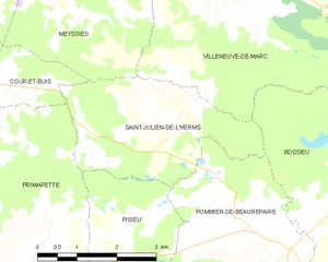
Сен-Жюльен-де-л'Эрмс
- коммуна во Франции
Hiking in Сен-Жюльен-де-л'Эрмс
Saint-Julien-de-l'Herms is a charming village located in the French Alps, known for its stunning natural landscapes and outdoor recreational opportunities....
- Страна:
- Почтовый код: 38122
- Координаты: 45° 25' 57" N, 5° 5' 40" E
- GPS треки (wikiloc): [Ссылка]
- Площадь: 9.17 кв.км
- Население: 144


Помье-де-Борепер
- коммуна во Франции
Hiking in Помье-де-Борепер
Pommier-de-Beaurepaire is a small commune in the Auvergne-Rhône-Alpes region of France, known for its scenic landscapes and rural charm. While it may not be as well-known as some major hiking destinations, it offers opportunities for outdoor enthusiasts to explore the beauty of the surrounding countryside....
- Страна:
- Почтовый код: 38260
- Координаты: 45° 24' 0" N, 5° 7' 11" E
- GPS треки (wikiloc): [Ссылка]
- Площадь: 19.16 кв.км
- Население: 710


Пизьё
- коммуна во Франции
Hiking in Пизьё
Pisieu, a commune located in the Auvergne-Rhône-Alpes region of France, offers beautiful landscapes and opportunities for hiking enthusiasts. While it may not be as widely known as some larger hiking destinations, it provides access to picturesque trails through the surrounding natural areas....
- Страна:
- Почтовый код: 38270
- Координаты: 45° 23' 14" N, 5° 3' 37" E
- GPS треки (wikiloc): [Ссылка]
- Площадь: 18.76 кв.км
- Население: 538
- Веб сайт: [Ссылка]

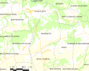
Примарет
- коммуна во Франции
Hiking in Примарет
It seems there might be a typo or misunderstanding regarding "Primarette." I am not familiar with a specific hiking location by that name. However, if you meant a different location, such as a national park, region, or trail, please clarify, and I’d be happy to provide information on hiking in that area!...
- Страна:
- Почтовый код: 38270
- Координаты: 45° 24' 7" N, 5° 1' 49" E
- GPS треки (wikiloc): [Ссылка]
- Площадь: 21.76 кв.км
- Население: 724
- Веб сайт: [Ссылка]


Монсеверу
- коммуна во Франции
Hiking in Монсеверу
Montseveroux is a beautiful area for hiking, located in the French Alps, specifically in the Isère department. The region is known for its stunning natural scenery, diverse landscapes, and the variety of trails suitable for different skill levels....
- Страна:
- Почтовый код: 38122
- Координаты: 45° 25' 44" N, 4° 58' 15" E
- GPS треки (wikiloc): [Ссылка]
- Площадь: 16.48 кв.км
- Население: 954
- Веб сайт: [Ссылка]


Муасьё-сюр-Долон
- коммуна во Франции
Hiking in Муасьё-сюр-Долон
Moissieu-sur-Dolon is a charming commune located in the Isère department of the Auvergne-Rhône-Alpes region in southeastern France. It is set in a picturesque landscape that can cater to various hiking enthusiasts, from beginners to more experienced trekkers. Here are some aspects of hiking in and around Moissieu-sur-Dolon:...
- Страна:
- Почтовый код: 38270
- Координаты: 45° 23' 10" N, 4° 59' 16" E
- GPS треки (wikiloc): [Ссылка]
- Площадь: 14.38 кв.км
- Население: 695


Кур-э-Бюи
- коммуна во Франции
Hiking in Кур-э-Бюи
Cour-et-Buis is a picturesque commune located in the Isère department in the Auvergne-Rhône-Alpes region of southeastern France. It offers beautiful natural landscapes, ideal for hiking enthusiasts. Here are some highlights about hiking in the area:...
- Страна:
- Почтовый код: 38122
- Координаты: 45° 26' 25" N, 5° 0' 18" E
- GPS треки (wikiloc): [Ссылка]
- Высота над уровнем моря: 462 м m
- Площадь: 13.73 кв.км
- Население: 852
- Веб сайт: [Ссылка]


Пакт
- коммуна во Франции
Hiking in Пакт
Hiking in Pact, located in the Isère department of the Auvergne-Rhône-Alpes region in France, offers an excellent opportunity to explore the natural beauty of the Alps and the surrounding landscapes. Here are some key points to consider when hiking in and around Pact:...
- Страна:
- Почтовый код: 38270
- Координаты: 45° 21' 10" N, 4° 59' 29" E
- GPS треки (wikiloc): [Ссылка]
- Площадь: 9.74 кв.км
- Население: 840
- Веб сайт: [Ссылка]
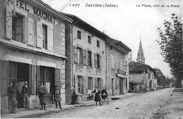
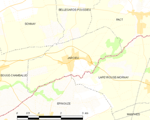
Жарсье
- коммуна во Франции
Hiking in Жарсье
Jarcieu is a charming village located in the Isère department in southeastern France. The area is surrounded by beautiful landscapes and offers a variety of opportunities for hiking enthusiasts, ranging from leisurely walks to more challenging trails. Here are some highlights and tips for hiking in Jarcieu:...
- Страна:
- Почтовый код: 38270
- Координаты: 45° 20' 2" N, 4° 56' 47" E
- GPS треки (wikiloc): [Ссылка]
- Площадь: 6.31 кв.км
- Население: 1028
- Веб сайт: [Ссылка]


Бельгард-Пусьё
- коммуна во Франции
Hiking in Бельгард-Пусьё
Bellegarde-Poussieu is a charming commune located in the Isère department in the Auvergne-Rhône-Alpes region of southeastern France. The area is known for its beautiful landscapes, rolling hills, and proximity to both the Rhône Valley and the foothills of the Alps, making it a great location for hiking enthusiasts....
- Страна:
- Почтовый код: 38270
- Координаты: 45° 22' 30" N, 4° 57' 3" E
- GPS треки (wikiloc): [Ссылка]
- Площадь: 16.79 кв.км
- Население: 982


Ревель-Турдан
- коммуна во Франции
Hiking in Ревель-Турдан
Revel-Tourdan, located in the Auvergne-Rhône-Alpes region of southeastern France, offers a picturesque setting for hiking enthusiasts. The area is known for its rolling hills, charming rural landscapes, and access to the rugged beauty of the surrounding mountains....
- Страна:
- Почтовый код: 38270
- Координаты: 45° 23' 4" N, 5° 2' 14" E
- GPS треки (wikiloc): [Ссылка]
- Площадь: 11.62 кв.км
- Население: 1042
- Веб сайт: [Ссылка]


Сен-Бартельми
Hiking in Сен-Бартельми
Saint-Barthélemy is a beautiful commune in the Isère department of the Auvergne-Rhône-Alpes region in southeastern France. Known for its picturesque landscapes, hiking in this area can vary from gentle strolls to more challenging hikes that reward adventurers with stunning views of the surrounding Alps and valleys....
- Страна:
- Почтовый код: 38270
- Координаты: 45° 20' 47" N, 5° 4' 49" E
- GPS треки (wikiloc): [Ссылка]
- Площадь: 7.98 кв.км
- Население: 962
- Веб сайт: [Ссылка]

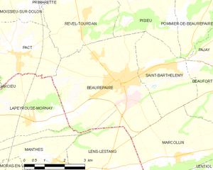
Борепер
- коммуна во Франции
Hiking in Борепер
Beaurepaire, located in the Isère department of France, is a charming commune that offers a variety of hiking opportunities. Nestled in the Rhône-Alpes region, it's surrounded by beautiful landscapes, including rolling hills and valleys, making it a great spot for outdoor enthusiasts....
- Страна:
- Почтовый код: 38270
- Координаты: 45° 20' 18" N, 5° 3' 16" E
- GPS треки (wikiloc): [Ссылка]
- Площадь: 18.46 кв.км
- Население: 4891
- Веб сайт: [Ссылка]


Монстеру-Мильё
- коммуна во Франции
Hiking in Монстеру-Мильё
Monsteroux-Milieu, located in the Isère department of the Auvergne-Rhône-Alpes region in France, is a fantastic destination for hiking enthusiasts. The area is known for its stunning natural landscapes, diverse terrain, and a variety of trails suited for different levels of hikers. Here are some key points to know about hiking in Monsteroux-Milieu:...
- Страна:
- Почтовый код: 38122
- Координаты: 45° 25' 56" N, 4° 56' 12" E
- GPS треки (wikiloc): [Ссылка]
- Площадь: 8.17 кв.км
- Население: 785