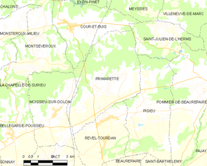
Ревель-Турдан (Revel-Tourdan, Revel-Tourdan)

- коммуна во Франции
 Hiking in Ревель-Турдан
Revel-Tourdan, located in the Auvergne-Rhône-Alpes region of southeastern France, offers a picturesque setting for hiking enthusiasts. The area is known for its rolling hills, charming rural landscapes, and access to the rugged beauty of the surrounding mountains.
Hiking Trails
- Les Monts du Lyonnais: This nearby range provides a variety of trails suitable for all levels, offering breathtaking views of the Rhône Valley and the Alps on clear days.
- Greenways: Revel-Tourdan has several marked routes that are easy to navigate and are perfect for leisurely walks or family hikes. These paths often run through vineyards and farmland, showcasing the region's agricultural heritage.
- Local Nature Reserves: Explore various nature reserves that highlight local flora and fauna, with trails designed to educate hikers about the ecosystem.
Hiking Season
- Spring to Fall: The best time to hike is from spring through fall when the weather is mild and the landscape is vibrant with flowers and greenery.
- Winter Hiking: While the colder months can be harsher, certain trails may still be accessible for those interested in winter hiking, though preparation and proper gear are essential.
Planning Your Hike
- Maps and Guides: It’s advisable to acquire local hiking maps or apps to navigate the trails and make the most of your experience.
- Safety Planning: Always inform someone about your hiking plans, make sure you have adequate provisions (water, snacks), and check the weather conditions in advance.
Additional Activities
In addition to hiking, the area offers opportunities for cycling, nature observation, and visiting local vineyards for tastings. The charming villages nearby provide cultural insights and a chance to enjoy the local cuisine after a day of outdoor exploration.
With its diverse trails and stunning natural landscapes, Revel-Tourdan is an excellent choice for a hiking adventure. Enjoy the tranquility and beauty that this region has to offer!
- Страна:

- Почтовый код: 38270
- Координаты: 45° 23' 4" N, 5° 2' 14" E


- GPS треки (wikiloc): [Ссылка]
- Площадь: 11.62 кв.км
- Население: 1042
- Веб сайт: http://www.revel-tourdan.fr
- Википедия русская: wiki(ru)
- Википедия английская: wiki(en)
- Википедия национальная: wiki(fr)
- Хранилище Wikidata: Wikidata: Q630598
- Катеория в википедии: [Ссылка]
- код Freebase: [/m/03g_6hb]
- код GeoNames: Альт: [6433304]
- номер SIREN: [213803356]
- код BNF: [15258146r]
- код тезауруса PACTOLS: [pcrtYDopWsNq37]
- код муниципалитета INSEE: 38335
Граничит с регионами:


Пизьё
- коммуна во Франции
Hiking in Пизьё
Pisieu, a commune located in the Auvergne-Rhône-Alpes region of France, offers beautiful landscapes and opportunities for hiking enthusiasts. While it may not be as widely known as some larger hiking destinations, it provides access to picturesque trails through the surrounding natural areas....
- Страна:
- Почтовый код: 38270
- Координаты: 45° 23' 14" N, 5° 3' 37" E
- GPS треки (wikiloc): [Ссылка]
- Площадь: 18.76 кв.км
- Население: 538
- Веб сайт: [Ссылка]

Примарет
- коммуна во Франции
Hiking in Примарет
It seems there might be a typo or misunderstanding regarding "Primarette." I am not familiar with a specific hiking location by that name. However, if you meant a different location, such as a national park, region, or trail, please clarify, and I’d be happy to provide information on hiking in that area!...
- Страна:
- Почтовый код: 38270
- Координаты: 45° 24' 7" N, 5° 1' 49" E
- GPS треки (wikiloc): [Ссылка]
- Площадь: 21.76 кв.км
- Население: 724
- Веб сайт: [Ссылка]


Муасьё-сюр-Долон
- коммуна во Франции
Hiking in Муасьё-сюр-Долон
Moissieu-sur-Dolon is a charming commune located in the Isère department of the Auvergne-Rhône-Alpes region in southeastern France. It is set in a picturesque landscape that can cater to various hiking enthusiasts, from beginners to more experienced trekkers. Here are some aspects of hiking in and around Moissieu-sur-Dolon:...
- Страна:
- Почтовый код: 38270
- Координаты: 45° 23' 10" N, 4° 59' 16" E
- GPS треки (wikiloc): [Ссылка]
- Площадь: 14.38 кв.км
- Население: 695


Пакт
- коммуна во Франции
Hiking in Пакт
Hiking in Pact, located in the Isère department of the Auvergne-Rhône-Alpes region in France, offers an excellent opportunity to explore the natural beauty of the Alps and the surrounding landscapes. Here are some key points to consider when hiking in and around Pact:...
- Страна:
- Почтовый код: 38270
- Координаты: 45° 21' 10" N, 4° 59' 29" E
- GPS треки (wikiloc): [Ссылка]
- Площадь: 9.74 кв.км
- Население: 840
- Веб сайт: [Ссылка]

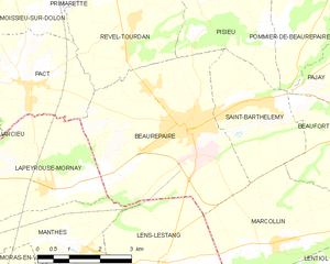
Борепер
- коммуна во Франции
Hiking in Борепер
Beaurepaire, located in the Isère department of France, is a charming commune that offers a variety of hiking opportunities. Nestled in the Rhône-Alpes region, it's surrounded by beautiful landscapes, including rolling hills and valleys, making it a great spot for outdoor enthusiasts....
- Страна:
- Почтовый код: 38270
- Координаты: 45° 20' 18" N, 5° 3' 16" E
- GPS треки (wikiloc): [Ссылка]
- Площадь: 18.46 кв.км
- Население: 4891
- Веб сайт: [Ссылка]