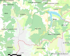
canton of Corps (canton de Corps)
 Hiking in canton of Corps
Canton de Corps, located in the French Alps, offers a stunning backdrop for hiking enthusiasts. This region is characterized by its breathtaking landscapes, diverse ecosystems, and a variety of trails suitable for different skill levels. Here are some highlights you might find interesting:
Trails and Routes
-
GR54 - Tour des Écrins: This popular long-distance hiking trail circles the Écrins National Park and passes through the Canton de Corps. The trail features diverse terrain, including alpine meadows, rocky passes, and scenic views of glaciers.
-
Local Trails: There are several well-marked local paths that lead to picturesque spots such as the Lake of Valbonnais or the Col de l'Arc. These trails can range from easy day hikes to more challenging ascents.
Scenic Highlights
- Lake of Valbonnais: An ideal spot for a leisurely hike, with views reflecting the surrounding mountains.
- Views of the Oisans Range: Many trails provide stunning vistas of the nearby peaks, particularly from higher elevations.
Flora and Fauna
Hiking in the Canton de Corps offers the opportunity to see a variety of alpine flora and fauna. Keep an eye out for wildflowers like gentians and edelweiss, as well as wildlife such as chamois and marmots.
Practical Considerations
- Season: The best hiking months are typically late spring through early autumn. Be cautious of snowpack on the higher trails in early summer, and monitor weather conditions.
- Gear: Ensure you have appropriate gear, including sturdy hiking boots, weather-resistant clothing, and enough water and snacks.
- Maps and Guides: While many trails are well-marked, it’s always wise to carry a detailed map or GPS device. There are also local guides available for those looking for a more informative experience.
Safety Tips
- Inform someone about your hiking plans, especially if you are going alone or to remote areas.
- Be aware of altitude sickness if you are attempting higher trails.
- Always check local weather forecasts before heading out.
Whether you're a seasoned hiker or a beginner, the Canton de Corps has something to offer. It's a beautiful place to connect with nature and experience the majestic Alps!
- Страна:

- Столица: Корп
- Координаты: 44° 49' 58" N, 5° 54' 31" E


- GPS треки (wikiloc): [Ссылка]
- Хранилище Wikidata: Wikidata: Q1725047
- код кантона INSEE: [3806]
Включает регионы:


Корп
- коммуна во Франции
Hiking in Корп
Hiking in Corps, Isère, is a fantastic experience for outdoor enthusiasts, thanks to its stunning natural landscapes and diverse trails. Located in the French Alps, this charming commune serves as a gateway to the Écrins National Park, which boasts dramatic mountain scenery, glacial lakes, and rugged terrain....
- Страна:
- Почтовый код: 38970
- Координаты: 44° 49' 6" N, 5° 56' 49" E
- GPS треки (wikiloc): [Ссылка]
- Площадь: 11.22 кв.км
- Население: 478
- Веб сайт: [Ссылка]


Ле-Кот-де-Кор
- коммуна во Франции
Hiking in Ле-Кот-де-Кор
Les Côtes-de-Corps, located in the Auvergne-Rhône-Alpes region of France, offers beautiful hiking opportunities amidst stunning natural landscapes. The area is known for its rugged terrain, rich biodiversity, and picturesque views of the surrounding mountains....
- Страна:
- Почтовый код: 38970
- Координаты: 44° 49' 56" N, 5° 55' 23" E
- GPS треки (wikiloc): [Ссылка]
- Высота над уровнем моря: 930 м m
- Площадь: 9.83 кв.км
- Население: 67


Амбель
Hiking in Амбель
Hiking in Ambel, located in the Isère department of the Auvergne-Rhône-Alpes region in France, offers a serene experience surrounded by beautiful landscapes, mountainous terrain, and rich biodiversity. Here are some key points to know about hiking in this area:...
- Страна:
- Почтовый код: 38970
- Координаты: 44° 48' 18" N, 5° 55' 50" E
- GPS треки (wikiloc): [Ссылка]
- Площадь: 4.83 кв.км
- Население: 22


Монестье-д'Амбель
- коммуна во Франции
Hiking in Монестье-д'Амбель
Monestier-d'Ambel is a picturesque commune located in the Isère department in the Auvergne-Rhône-Alpes region of southeastern France. Nestled in the French Alps, it offers a variety of hiking opportunities for outdoor enthusiasts. Here are some details about hiking in this area:...
- Страна:
- Почтовый код: 38970
- Координаты: 44° 46' 40" N, 5° 55' 37" E
- GPS треки (wikiloc): [Ссылка]
- Площадь: 11.02 кв.км
- Население: 22
- Веб сайт: [Ссылка]


Сент-Люс
Hiking in Сент-Люс
Sainte-Luce, located in the Isère department in the Auvergne-Rhône-Alpes region of southeastern France, offers a variety of hiking opportunities, characterized by beautiful landscapes, lush forests, and views of the surrounding mountains....
- Страна:
- Почтовый код: 38970
- Координаты: 44° 51' 2" N, 5° 54' 42" E
- GPS треки (wikiloc): [Ссылка]
- Площадь: 7.95 кв.км
- Население: 43


Сен-Лоран-ан-Бомон
- коммуна во Франции
Hiking in Сен-Лоран-ан-Бомон
Saint-Laurent-en-Beaumont is a charming commune located in the Isère department in the Auvergne-Rhône-Alpes region of southeastern France. It offers excellent opportunities for hiking and outdoor activities, set amidst stunning natural scenery, including mountains and forests....
- Страна:
- Почтовый код: 38350
- Координаты: 44° 52' 45" N, 5° 51' 1" E
- GPS треки (wikiloc): [Ссылка]
- Площадь: 13.15 кв.км
- Население: 462
- Веб сайт: [Ссылка]


Сен-Пьер-де-Меаро
- коммуна во Франции
Hiking in Сен-Пьер-де-Меаро
Saint-Pierre-de-Méaroz is a small village located in the Auvergne-Rhône-Alpes region of France, often considered part of the scenic landscapes of the French Alps. The area offers a variety of hiking opportunities that cater to different skill levels and preferences....
- Страна:
- Почтовый код: 38350
- Координаты: 44° 52' 30" N, 5° 49' 25" E
- GPS треки (wikiloc): [Ссылка]
- Площадь: 4.64 кв.км
- Население: 132

Пеллафоль
- коммуна во Франции
Hiking in Пеллафоль
Pellafol, a picturesque village located in the Isère department of the Auvergne-Rhône-Alpes region in France, is a hidden gem for hiking enthusiasts. Nestled in the foothills of the French Alps, it offers stunning landscapes, diverse flora and fauna, and a variety of trails suitable for all skill levels....
- Страна:
- Почтовый код: 38970
- Координаты: 44° 47' 51" N, 5° 54' 27" E
- GPS треки (wikiloc): [Ссылка]
- Площадь: 34.73 кв.км
- Население: 137


Бофен
- коммуна во Франции
Hiking in Бофен
Beaufin is not a widely recognized hiking destination, and there may be some confusion about the name. However, if you meant Beaufort, a region in various countries, or perhaps a specific national park or area with a similar name, please clarify!...
- Страна:
- Почтовый код: 38970
- Координаты: 44° 47' 16" N, 5° 57' 36" E
- GPS треки (wikiloc): [Ссылка]
- Площадь: 6.36 кв.км
- Население: 21


Сен-Мишель-ан-Бомон
- коммуна во Франции
Hiking in Сен-Мишель-ан-Бомон
Saint-Michel-en-Beaumont is a picturesque village located in the Auvergne-Rhône-Alpes region of southeastern France. This area is known for its stunning natural landscapes, rolling hills, and diverse outdoor activities, making it a great destination for hiking enthusiasts....
- Страна:
- Почтовый код: 38350
- Координаты: 44° 52' 6" N, 5° 53' 59" E
- GPS треки (wikiloc): [Ссылка]
- Площадь: 8.04 кв.км
- Население: 31
- Веб сайт: [Ссылка]

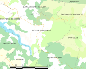
Ла-Саль-ан-Бомон
- коммуна во Франции
Hiking in Ла-Саль-ан-Бомон
La Salle-en-Beaumont is a picturesque commune located in the Isère department of the Auvergne-Rhône-Alpes region in southeastern France. It is surrounded by the stunning natural landscapes of the French Alps, making it an excellent destination for hiking enthusiasts....
- Страна:
- Почтовый код: 38350
- Координаты: 44° 51' 43" N, 5° 51' 50" E
- GPS треки (wikiloc): [Ссылка]
- Площадь: 9.26 кв.км
- Население: 323
- Веб сайт: [Ссылка]
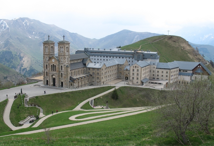

Ла-Салетт-Фаллаво
- коммуна во Франции
Hiking in Ла-Салетт-Фаллаво
La Salette-Fallavaux is a beautiful area nestled in the French Alps, famous for its stunning natural landscapes, history, and religious significance. Here are some key points about hiking in this region:...
- Страна:
- Почтовый код: 38970
- Координаты: 44° 50' 26" N, 5° 58' 30" E
- GPS треки (wikiloc): [Ссылка]
- Площадь: 22.29 кв.км
- Население: 68


Кет-ан-Бомон
- коммуна во Франции
Hiking in Кет-ан-Бомон
Quet-en-Beaumont is a charming destination for hiking enthusiasts. Nestled in the beautiful surroundings of the French Alps, this area offers a range of hiking trails suitable for various skill levels. Here are some key points to consider for your hiking adventure in Quet-en-Beaumont:...
- Страна:
- Почтовый код: 38970
- Координаты: 44° 50' 5" N, 5° 52' 25" E
- GPS треки (wikiloc): [Ссылка]
- Площадь: 8.1 кв.км
- Население: 65