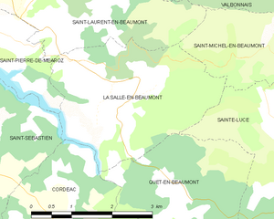
Ла-Саль-ан-Бомон (La Salle-en-Beaumont, La Salle-en-Beaumont)
- коммуна во Франции
La Salle-en-Beaumont is a picturesque commune located in the Isère department of the Auvergne-Rhône-Alpes region in southeastern France. It is surrounded by the stunning natural landscapes of the French Alps, making it an excellent destination for hiking enthusiasts.
Hiking in La Salle-en-Beaumont
-
Scenic Trails: The area features a variety of hiking trails that cater to different skill levels. Whether you are a beginner looking for leisurely walks or an experienced hiker seeking challenging routes, you'll find something suitable.
-
Natural Beauty: The trails offer breathtaking views of the surrounding mountains, valleys, and forests. Be sure to bring your camera, as the landscapes can be quite captivating, especially during sunrise and sunset.
-
Flora and Fauna: As you hike, you'll have the opportunity to encounter diverse flora and fauna. The region is home to various species of plants and animals, and the changing seasons can dramatically alter the scenery.
-
Nearby Attractions: La Salle-en-Beaumont is close to several notable landmarks and natural sites, such as the Écrins National Park, which is well-known for its spectacular mountain scenery and rich biodiversity. This park also provides numerous hiking options with varied difficulty levels.
-
Local Culture: The area is steeped in local culture and history. Take some time to explore the charming village, experience its traditional architecture, and perhaps enjoy some local cuisine after your hike.
-
Safety and Preparation: As with any hiking trip, ensure you're well-prepared. Check the weather forecast, wear appropriate footwear, carry enough water and snacks, and follow marked trails to stay safe. Consider informing someone of your hiking plans, especially if venturing into less populated areas.
-
Access and Transportation: La Salle-en-Beaumont is accessible by road, and you can often find parking near trailheads. Public transport options may be limited, so it’s advisable to consider driving or checking local transport services.
Whether you're looking for a day hike or planning to explore the area for a longer trek, La Salle-en-Beaumont provides a wonderful backdrop for outdoor adventures. Always remember to respect nature and local regulations while enjoying your hike!
- Страна:

- Почтовый код: 38350
- Координаты: 44° 51' 43" N, 5° 51' 50" E


- GPS треки (wikiloc): [Ссылка]
- Площадь: 9.26 кв.км
- Население: 323
- Веб сайт: http://www.la-salle-en-beaumont.fr
- Википедия русская: wiki(ru)
- Википедия английская: wiki(en)
- Википедия национальная: wiki(fr)
- Хранилище Wikidata: Wikidata: Q513040
- Катеория в википедии: [Ссылка]
- код Freebase: [/m/03nvkx4]
- код GeoNames: Альт: [6455953]
- номер SIREN: [213804701]
- код BNF: [15258276z]
- код муниципалитета INSEE: 38470
Граничит с регионами:


Кордеак
- коммуна во Франции
Cordéac is a small village located in the French Alps, offering stunning natural landscapes ideal for hiking. The region is well-suited for both experienced hikers and those looking for gentler trails. Here are some highlights to consider when hiking in Cordéac:...
- Страна:

- Почтовый код: 38710
- Координаты: 44° 49' 38" N, 5° 50' 17" E


- GPS треки (wikiloc): [Ссылка]
- Площадь: 26.62 кв.км
- Население: 200


Сент-Люс
Sainte-Luce, located in the Isère department in the Auvergne-Rhône-Alpes region of southeastern France, offers a variety of hiking opportunities, characterized by beautiful landscapes, lush forests, and views of the surrounding mountains....
- Страна:

- Почтовый код: 38970
- Координаты: 44° 51' 2" N, 5° 54' 42" E


- GPS треки (wikiloc): [Ссылка]
- Площадь: 7.95 кв.км
- Население: 43

Сен-Лоран-ан-Бомон
- коммуна во Франции
Saint-Laurent-en-Beaumont is a charming commune located in the Isère department in the Auvergne-Rhône-Alpes region of southeastern France. It offers excellent opportunities for hiking and outdoor activities, set amidst stunning natural scenery, including mountains and forests....
- Страна:

- Почтовый код: 38350
- Координаты: 44° 52' 45" N, 5° 51' 1" E


- GPS треки (wikiloc): [Ссылка]
- Площадь: 13.15 кв.км
- Население: 462
- Веб сайт: [Ссылка]


Сен-Пьер-де-Меаро
- коммуна во Франции
Saint-Pierre-de-Méaroz is a small village located in the Auvergne-Rhône-Alpes region of France, often considered part of the scenic landscapes of the French Alps. The area offers a variety of hiking opportunities that cater to different skill levels and preferences....
- Страна:

- Почтовый код: 38350
- Координаты: 44° 52' 30" N, 5° 49' 25" E


- GPS треки (wikiloc): [Ссылка]
- Площадь: 4.64 кв.км
- Население: 132


Сен-Мишель-ан-Бомон
- коммуна во Франции
Saint-Michel-en-Beaumont is a picturesque village located in the Auvergne-Rhône-Alpes region of southeastern France. This area is known for its stunning natural landscapes, rolling hills, and diverse outdoor activities, making it a great destination for hiking enthusiasts....
- Страна:

- Почтовый код: 38350
- Координаты: 44° 52' 6" N, 5° 53' 59" E


- GPS треки (wikiloc): [Ссылка]
- Площадь: 8.04 кв.км
- Население: 31
- Веб сайт: [Ссылка]


Сен-Себастьен
Saint-Sébastien is a charming commune in the Isère department of the Auvergne-Rhône-Alpes region in France. The area is known for its beautiful mountain landscapes, making it an excellent destination for hiking enthusiasts. Here are some insights into hiking in and around Saint-Sébastien:...
- Страна:

- Почтовый код: 38710
- Координаты: 44° 50' 50" N, 5° 47' 57" E


- GPS треки (wikiloc): [Ссылка]
- Площадь: 20.98 кв.км
- Население: 259
- Веб сайт: [Ссылка]


Кет-ан-Бомон
- коммуна во Франции
Quet-en-Beaumont is a charming destination for hiking enthusiasts. Nestled in the beautiful surroundings of the French Alps, this area offers a range of hiking trails suitable for various skill levels. Here are some key points to consider for your hiking adventure in Quet-en-Beaumont:...
- Страна:

- Почтовый код: 38970
- Координаты: 44° 50' 5" N, 5° 52' 25" E


- GPS треки (wikiloc): [Ссылка]
- Площадь: 8.1 кв.км
- Население: 65

