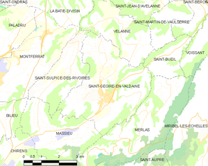
canton of Saint-Geoire-en-Valdaine (canton de Saint-Geoire-en-Valdaine)
 Hiking in canton of Saint-Geoire-en-Valdaine
Canton de Saint-Geoire-en-Valdaine, located in the Isère department of the Auvergne-Rhône-Alpes region in southeastern France, offers a variety of hiking opportunities for outdoor enthusiasts. The terrain features a mix of rolling hills, forests, and picturesque landscapes that characterize the region.
Hiking Highlights:
-
Scenic Trails: The area is dotted with numerous marked trails suitable for all levels, from leisurely walks to more challenging hikes. Many trails provide stunning views of the surrounding mountains and valleys.
-
Natural Attractions: The canton is near several natural parks and reserves, such as the Chartreuse Regional Natural Park, which is known for its rugged terrain, vibrant biodiversity, and beautiful landscapes.
-
Historical Sites: While hiking, you can explore historical landmarks and charming villages, adding a cultural dimension to your outdoor experience. Many trails lead to charming viewpoints and sites of historical significance.
-
Wildlife Viewing: The region's diverse habitats are home to a variety of wildlife, making it a great spot for nature lovers and birdwatchers.
-
Local Culture: You may also encounter local farms, vineyards, and markets along your hikes, giving you a taste of the region's culture and gastronomy.
Recommendations:
-
Trail Maps: Before heading out, it’s a good idea to obtain a trail map or use a reliable hiking app to navigate the pathways easily.
-
Footwear: Ensure you have sturdy hiking boots with good grip, as some trails may be uneven or steep.
-
Water and Snacks: Carry plenty of water and some snacks to keep your energy levels up during your hikes.
-
Weather Check: Be sure to check the weather forecast before you head out, as conditions can change quickly in mountainous regions.
-
Respect Nature: Follow Leave No Trace principles to protect the beautiful landscapes and wildlife.
Whether you're seeking a peaceful walk in nature or a more challenging hike, Canton de Saint-Geoire-en-Valdaine has a plethora of options that cater to every hiker. Enjoy your adventure!
- Страна:

- Столица: Сен-Жуар-ан-Вальден
- Координаты: 45° 28' 39" N, 5° 37' 29" E


- GPS треки (wikiloc): [Ссылка]
- Хранилище Wikidata: Wikidata: Q1727153
- код кантона INSEE: [3827]
Включает регионы:

Сен-Жуар-ан-Вальден
- коммуна во Франции
Hiking in Сен-Жуар-ан-Вальден
Saint-Geoire-en-Valdaine is a picturesque commune located in the Isère department in the Auvergne-Rhône-Alpes region of southeastern France. The area is rich in natural beauty and offers various opportunities for hiking and outdoor activities....
- Страна:
- Почтовый код: 38620
- Координаты: 45° 27' 25" N, 5° 38' 7" E
- GPS треки (wikiloc): [Ссылка]
- Площадь: 16.73 кв.км
- Население: 2417
- Веб сайт: [Ссылка]


Ла-Бати-Дивизен
- коммуна во Франции
Hiking in Ла-Бати-Дивизен
La Bâtie-Divisin is a charming commune in the Isère department of the Auvergne-Rhône-Alpes region in southeastern France. Nestled near the foothills of the Alps, it offers a picturesque setting for hiking enthusiasts. Here are some key points about hiking in and around La Bâtie-Divisin:...
- Страна:
- Почтовый код: 38490
- Координаты: 45° 30' 36" N, 5° 35' 52" E
- GPS треки (wikiloc): [Ссылка]
- Площадь: 10.51 кв.км
- Население: 917
- Веб сайт: [Ссылка]


Сен-Сюльпис-де-Ривуар
- коммуна во Франции
Hiking in Сен-Сюльпис-де-Ривуар
Saint-Sulpice-des-Rivoires is a charming commune located in the Isère department of the Auvergne-Rhône-Alpes region in southeastern France. The area is known for its beautiful landscapes and outdoor activities, including hiking. Here are some key points to consider if you're planning to hike in and around Saint-Sulpice-des-Rivoires:...
- Страна:
- Почтовый код: 38620
- Координаты: 45° 28' 8" N, 5° 36' 34" E
- GPS треки (wikiloc): [Ссылка]
- Площадь: 7.16 кв.км
- Население: 435

Монферра
- коммуна во Франции
Hiking in Монферра
Montferrat, located in the Isère department of the Auvergne-Rhône-Alpes region in southeastern France, offers stunning hiking opportunities through its picturesque landscapes. Here are some key points to consider for hiking in Montferrat:...
- Страна:
- Почтовый код: 38620
- Координаты: 45° 29' 16" N, 5° 35' 27" E
- GPS треки (wikiloc): [Ссылка]
- Площадь: 12.26 кв.км
- Население: 1767
- Веб сайт: [Ссылка]


Мерла
- коммуна во Франции
Hiking in Мерла
Mereis, located in Portugal, is known for its beautiful natural landscapes and hiking opportunities. Here are some tips and information about hiking in the area:...
- Страна:
- Почтовый код: 38620
- Координаты: 45° 26' 41" N, 5° 39' 46" E
- GPS треки (wikiloc): [Ссылка]
- Площадь: 15.64 кв.км
- Население: 499


Паладрю
- коммуна во Франции
Hiking in Паладрю
Hiking in Paladru, located in the Auvergne-Rhône-Alpes region of France, offers a beautiful blend of natural landscapes, cultural heritage, and outdoor activities. The area is known for its stunning lake, Lac de Paladru, which is one of the cleanest lakes in the region and provides a picturesque backdrop for hiking....
- Страна:
- Почтовый код: 38137
- Координаты: 45° 28' 33" N, 5° 33' 12" E
- GPS треки (wikiloc): [Ссылка]
- Площадь: 11.64 кв.км
- Население: 1181
- Веб сайт: [Ссылка]


Сен-Бюэй
- коммуна во Франции
Hiking in Сен-Бюэй
Saint-Bueil is a charming village located in the Isère department of the Auvergne-Rhône-Alpes region in southeastern France. While it may not be as widely recognized as some other hiking destinations in the area, it offers beautiful landscapes and opportunities for outdoor activities, including hiking....
- Страна:
- Почтовый код: 38620
- Координаты: 45° 28' 38" N, 5° 41' 23" E
- GPS треки (wikiloc): [Ссылка]
- Площадь: 3.81 кв.км
- Население: 702


Шарансьё
- коммуна во Франции
Hiking in Шарансьё
Charancieu, located in the Isère department of the Auvergne-Rhône-Alpes region in France, offers beautiful scenery and a variety of hiking opportunities. The area is characterized by rolling hills, lush greenery, and stunning views of the surrounding mountains....
- Страна:
- Почтовый код: 38490
- Координаты: 45° 31' 30" N, 5° 34' 54" E
- GPS треки (wikiloc): [Ссылка]
- Площадь: 5.53 кв.км
- Население: 741


Веланн
- коммуна во Франции
Hiking in Веланн
Velanne is a charming village located in the French Alps, nestled within the picturesque Isère department. While not as widely known as some of its neighboring areas, it offers access to beautiful landscapes and hiking opportunities perfect for outdoor enthusiasts....
- Страна:
- Почтовый код: 38620
- Координаты: 45° 29' 18" N, 5° 38' 54" E
- GPS треки (wikiloc): [Ссылка]
- Площадь: 8.04 кв.км
- Население: 524


Вуассан
- коммуна во Франции
Hiking in Вуассан
Voissant is a charming village located in the Isère department of the Auvergne-Rhône-Alpes region in southeastern France. While it may not be as widely known as some of the larger hiking destinations, it offers a variety of outdoor activities and hiking opportunities amidst beautiful natural settings....
- Страна:
- Почтовый код: 38620
- Координаты: 45° 29' 1" N, 5° 42' 36" E
- GPS треки (wikiloc): [Ссылка]
- Площадь: 3.88 кв.км
- Население: 218


Масьё
Hiking in Масьё
Massieu is a beautiful area located in the French Alps, offering stunning views and diverse hiking opportunities. Here are some key points to know about hiking in Massieu:...
- Страна:
- Почтовый код: 38620
- Координаты: 45° 26' 23" N, 5° 35' 47" E
- GPS треки (wikiloc): [Ссылка]
- Площадь: 10.46 кв.км
- Население: 738
- Веб сайт: [Ссылка]