canton of Seyssel (canton de Seyssel)
 Hiking in canton of Seyssel
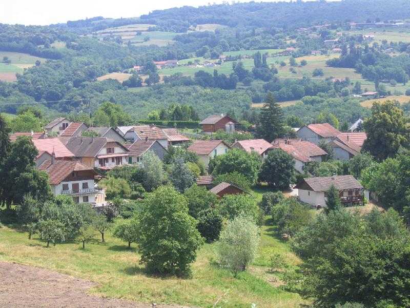
Canton de Seyssel, situated in the Haute-Savoie department of France, offers a beautiful backdrop for hiking enthusiasts, combining stunning landscapes with a variety of trails suitable for different skill levels. Here are some highlights and considerations for hiking in this region:
1.
- The canton features diverse landscapes that range from rolling hills to views of the Alps. You can enjoy picturesque views of Lake Geneva, the Rhône River, and the surrounding mountains.
2.
- The area is rich in biodiversity, home to various flora and fauna. Keep an eye out for local wildlife such as deer, foxes, and numerous bird species. In spring and summer, wildflowers bloom, adding to the scenic beauty.
3.
- Le Mont de la Grotte: This hike provides panoramic views of the region and is a moderate trek suitable for most hikers.
- Hiking along the Rhône: Follow trails that meander alongside the river, offering a flatter route with stunning river views. Ideal for a leisurely hike or a family outing.
- The Bugey Mountains: You can venture slightly outside the canton into the Bugey region for more challenging hikes that reward with breathtaking alpine vistas.
4.
- While hiking, you may encounter charming villages and historical landmarks. Pay attention to local architecture and cultural markers that enrich the hiking experience.
5.
- The canton features small towns and villages that offer amenities such as eateries, accommodation options, and local shops. After a hike, you can try regional specialties and enjoy local hospitality.
6.
- The best months for hiking in Canton de Seyssel are from late spring to early autumn (May to September). This period offers pleasant temperatures and accessible trails. However, always check local conditions and route specifics, as trails might vary due to weather.
7.
- Ensure you have appropriate hiking gear, sufficient water, and snacks. Always check the weather forecast and let someone know your plans before heading out. For more remote areas, a good map or GPS device is recommended.
Overall, hiking in Canton de Seyssel is a rewarding experience for both novice and experienced hikers, providing not only physical activity but also stunning natural beauty and cultural richness. Enjoy your hikes!
- Страна:

- Столица: Seyssel
- Координаты: 46° 0' 5" N, 5° 51' 36" E


- GPS треки (wikiloc): [Ссылка]
- Хранилище Wikidata: Wikidata: Q1727494
- код кантона INSEE: [7424]
Включает регионы:


Menthonnex-sous-Clermont
- коммуна во Франции
Hiking in Menthonnex-sous-Clermont
Menthonnex-sous-Clermont, located in the Auvergne-Rhône-Alpes region of France, offers a variety of hiking opportunities for outdoor enthusiasts. The area is characterized by its beautiful natural landscapes, including rolling hills, forests, and panoramic views of the surrounding mountains....
- Страна:
- Почтовый код: 74270
- Координаты: 45° 57' 57" N, 5° 56' 9" E
- GPS треки (wikiloc): [Ссылка]
- Площадь: 10.14 кв.км
- Население: 676

Bassy
- коммуна во Франции
Hiking in Bassy
It seems there might be a typo or misunderstanding regarding "Bassy," as it doesn't correspond to a well-known hiking destination. However, if you meant "Basilicata" in Italy, "Basse-Terre" in Guadeloupe, or a similar-sounding location, I can provide information on those areas....
- Страна:
- Почтовый код: 74910
- Координаты: 45° 58' 51" N, 5° 49' 47" E
- GPS треки (wikiloc): [Ссылка]
- Площадь: 7.57 кв.км
- Население: 417


Clermont
Hiking in Clermont
Clermont, located in the Haute-Savoie region of France, is surrounded by stunning mountainous landscapes, making it a great base for hiking enthusiasts. Here are some key features about hiking in and around Clermont:...
- Страна:
- Почтовый код: 74270
- Координаты: 45° 58' 19" N, 5° 54' 29" E
- GPS треки (wikiloc): [Ссылка]
- Площадь: 6.98 кв.км
- Население: 408


Challonges
- коммуна во Франции
Hiking in Challonges
Challonges is a charming area located in the Auvergne-Rhône-Alpes region of France, near the border with Switzerland. It offers a variety of hiking opportunities for different skill levels, with beautiful landscapes featuring rolling hills, forests, and the stunning backdrop of the Alps....
- Страна:
- Почтовый код: 74910
- Координаты: 46° 1' 10" N, 5° 49' 52" E
- GPS треки (wikiloc): [Ссылка]
- Площадь: 7.9 кв.км
- Население: 501


Desingy
- коммуна во Франции
Hiking in Desingy
Desingy, located in the Haute-Savoie region of France, offers a picturesque setting for hiking enthusiasts. It’s surrounded by the stunning landscapes of the French Alps, making it an excellent base for exploring various trails suitable for different skill levels....
- Страна:
- Почтовый код: 74270
- Координаты: 45° 59' 43" N, 5° 53' 24" E
- GPS треки (wikiloc): [Ссылка]
- Площадь: 18.93 кв.км
- Население: 799
- Веб сайт: [Ссылка]


Droisy
- коммуна во Франции
Hiking in Droisy
Droisy is a small commune located in the Haute-Savoie department in the Auvergne-Rhône-Alpes region of southeastern France. Nestled in the stunning French Alps, it offers a variety of hiking opportunities that allow you to explore both its natural beauty and cultural heritage....
- Страна:
- Почтовый код: 74270
- Координаты: 45° 57' 54" N, 5° 52' 58" E
- GPS треки (wikiloc): [Ссылка]
- Площадь: 4.55 кв.км
- Население: 164

Chêne-en-Semine
- коммуна во Франции
Hiking in Chêne-en-Semine
Chêne-en-Semine is a charming destination for hiking enthusiasts, located in the Auvergne-Rhône-Alpes region of France. Known for its picturesque natural surroundings, this area offers a variety of trails suitable for different skill levels. Here are some highlights of hiking in Chêne-en-Semine:...
- Страна:
- Почтовый код: 74270
- Координаты: 46° 2' 49" N, 5° 51' 31" E
- GPS треки (wikiloc): [Ссылка]
- Площадь: 9.46 кв.км
- Население: 463
- Веб сайт: [Ссылка]


Franclens
- коммуна во Франции
Hiking in Franclens
Franclens is a charming area located in the Haute-Savoie region of the French Alps. It offers beautiful landscapes and a range of hiking opportunities, suitable for various skill levels. Here are some highlights and tips for hiking in Franclens:...
- Страна:
- Почтовый код: 74910
- Координаты: 46° 2' 33" N, 5° 49' 47" E
- GPS треки (wikiloc): [Ссылка]
- Площадь: 5.37 кв.км
- Население: 529


Saint-Germain-sur-Rhône
- коммуна во Франции
Hiking in Saint-Germain-sur-Rhône
Saint-Germain-sur-Rhône is a picturesque commune located in the Auvergne-Rhône-Alpes region of France. It offers a variety of hiking opportunities, allowing visitors to explore the natural beauty of the surrounding countryside and enjoy scenic views of the Rhône River and the nearby landscapes....
- Страна:
- Почтовый код: 74910
- Координаты: 46° 4' 0" N, 5° 48' 52" E
- GPS треки (wikiloc): [Ссылка]
- Площадь: 7.85 кв.км
- Население: 507
- Веб сайт: [Ссылка]


Usinens
- коммуна во Франции
Hiking in Usinens
Usinens isn't a widely recognized hiking destination, and there may be a misunderstanding regarding the location. If you meant the general area of the U.S. or a specific region or park (like Yosemite in California or another area), please clarify, and I’d be happy to provide detailed information....
- Страна:
- Почтовый код: 74910
- Координаты: 46° 0' 32" N, 5° 50' 28" E
- GPS треки (wikiloc): [Ссылка]
- Площадь: 7.63 кв.км
- Население: 391


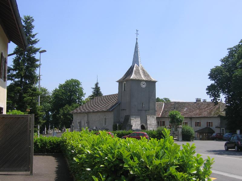
Seyssel
Hiking in Seyssel
Seyssel, located in the Haute-Savoie region of France, is a charming town nestled at the confluence of the Rhône and the Fier rivers. It's surrounded by beautiful natural landscapes, making it a great destination for hiking enthusiasts. Here’s an overview of what you can expect when hiking in the Seyssel area:...
- Страна:
- Почтовый код: 74910
- Координаты: 45° 57' 32" N, 5° 50' 11" E
- GPS треки (wikiloc): [Ссылка]
- Площадь: 16.86 кв.км
- Население: 2290